Showing posts with label mountains. Show all posts

Thursday, 2 June 2016

The Biggest Bird You'll Ever See?

We'd seen several condors before on our trip, most notably during our trek towards Machu Picchu and several around El Chaltén, but never close enough to really appreciate their size. This time, while walking early in the morning, all alone in the Quebrada del Condorito national park, we saw two figures on a nearby hill. At first, we thought they were two more people, detracting from our uniqueness, but then they spread their wings and took off! They were enormous. They can have a wingspan of up to 3.3m and weigh up to 15kg.

Condor flying overhead at Quebrada del Condorito
This wasn't our last encounter with condors for the day. When we reached the quebrada (canyon), we saw several more circling overhead and some landing on the opposite cliff. Then, a group of about 15-20 decided to pass right above us before flying into the distance. It was an incredible experience to see them swoop over us one by one before disappearing behind the mountain.

The Quebrada del Condorito
The national park was our highlight of our time in and around Córdoba, Argentina's second city. We liked the city itself - it's an old colonial city and is home to our final World Heritage Site for Argentina. Of course, it was another Jesuit mission. We did a short tour around the church, and discovered that the surrounding buildings are home to the country's oldest university. As a major university city, it was home to many of the 'Disappeared' - those who were killed by the military dictatorship during the '70s and '80s.

The entrance to the Jesuit church
After a lot of time sitting in cars and wine tasting, we wanted to do some hiking, and handily there are several small mountain ranges just outside Córdoba - the Sierras. We visited the small town of Capilla del Monte in the Sierras Chicas (Small Sierras), home to Uritorco Hill. This was perfect for our needs - a day long hike with pleasant views over the town and the nearby reservoir. Before we arrived, we hadn't done much more research than that, and we soon found that the town is full of UFO spotters, 'magical' rocks and plastic pyramids full of 'mysteries'. In 1986, a scorched patch of ground was found and this was subsequently blamed on aliens. You can now watch some incredibly unrealistic videos online, or buy plenty of little green man dolls.

A 'mystical' pyramid in Capilla del Monte
After Córdoba, we set off for our final country on this continent - Uruguay. We'll stop in a couple of places on the way to break up the journey, but not spend much time there, before crossing the border to Fray Bentos.

Wednesday, 25 May 2016

Wine Tasting (and a Run In with the Police)

We had been looking forward to visiting Mendoza for a while, for several reasons. Firstly, we'd arranged to reunite with our London friends Ralph and Shehnaaz there. Secondly, we hoped the climate might be a bit more forgiving - it's been pretty cold and grey for us recently but Mendoza is known for its sunny skies and lack of rain. And thirdly, it is of course Argentina's capital of wine. Buy any Argentinian wine in the UK, and the chances are pretty high that it's from Mendoza (and that it's a Malbec)! Arriving in the city in the late afternoon, alas, we were to be disappointed on the second of these counts - it was 8 degrees and tipping it down with rain. Ah well. Unfortunately, this weather continued for the majority of our time round Mendoza, but this did not impact too much on our enjoyment.

Wine tasting at Tempus Alba winery, in Maipú
Ralph and Shehnaaz met us on our first evening in Mendoza - we'd not realised they were intending to stay at the same hostel as us, so were surprised to hear familiar English voices downstairs! It was great to see them again and exchange stories of our very different last three months or so since we were last together in Colombia. While we'd been making haste through the Guyanas, Brazil and Paraguay, Ralph and Shehnaaz had spent the majority of their time driving through Patagonia in a van they'd hired and then converted themselves into a camper van. We had a look at the inside of the van (very impressive) and even had a ride in the back several times, slightly illegally!

We spent a day in Mendoza itself, wandering around chatting and avoiding the enormous holes in the road. Mendoza has huge drainage channels going down either side of its roads, and they aren't covered at all, so you frequently find yourself having to jump quite a distance to avoid falling in! There isn't actually a lot to see or do in the city - it's a pleasant enough place, with tree lined avenues and lots of squares, but few major sights to see. We did climb up to the top floor of the city hall, where there was a terrace with a view of the city. This was nice despite the grey skies. While we couldn't see much of the surrounding mountains (we're assured they do exist!) the view of the city itself helped to emphasise just how green (well, more yellow, orange and red, in this season) Mendoza is - there really are a lot more trees than your average city.

The two wines we managed to taste in Trapiche winery, Maipú
Of course, Mendoza's main draw is the surrounding wine growing region, and we duly spent most of our time in a couple of nearby towns that had plenty of bodegas for wine tasting. We made a point of avoiding the ridiculously overpriced tours that most people take to visit wineries near here, as it is perfectly possible to go independently to a lot of places. Our wine tasting adventures began with a day trip to the Maipú area (not to be confused with Chile's Maipo valley, also a wine region) an hour or so outside the city. Kev and I took the bus, while Ralph and Shehnaaz drove. Our hostel had recommended a winery called Trapiche, so we headed there first. Unfortunately, the man at the gatehouse told us we couldn't go in until 3pm, even though we only wanted to do a tasting, not the scheduled 3pm tour. We sat eating lunch in the back of the others' van for the required half an hour, and on entering the winery were told, oh, you only wanted to do a tasting, you could have come in straight away! Slightly frustrating!

A flock of geese in the grounds behind Trapiche winery
The winery was lovely, with a cool glass floor through which you could see barrels and barrels of maturing wine, some of them absolutely enormous, on the floor below. But sadly the tasting experience wasn't so good. The guy who'd let us in showed us to a table, plonked 2 bottles of wine and some glasses in front of us, and just left us to it! We weren't offered any information about the wines or the winery whatsoever, and both wines were straight out of a store cupboard so the white was too warm and the red too cold. We were a bit disappointed as we'd hoped for a better tasting experience here than in Cafayate, but again it seemed that staff could not really be bothered at all... unless you'd paid twice as much to do the guided tour as well as the tasting. We saw a group finishing their tour, upon which they got to try three wines, all well kept, with pourers on the bottles, and all introduced beforehand by a member of staff.  Still, maybe this was just bad luck, we thought, and drove on in the van to a different winery a few km down the road.

The next winery we tried was called El Cerno, and we arrived just as a lady from the winery was welcoming a tour group. The four of us stood awkwardly at the back, and were completely ignored by the staff - it was as if we didn't exist! Rude, we thought, and eventually decided to go across the road to a different place, leaving the van at El Cerno. This third winery, Tempus Alba, was much more of a success. We got to try six different reds, including a Merlot, Syrah and Tempranillo, which are a bit more unusual in Argentina. We had fun trying to identify them in a blind taste test, at which we all did surprisingly well. All the wines were very good, although the staff again just poured out the glasses and left us to it!

Autumnal vineyards under cloudy skies in Maipú
When we returned to El Cerno just before 6pm we had a shock: as we walked down the drive, we saw all the staff standing outside in their coats, clearly waiting for us to come back. Worse, we were overtaken on the drive by a police car! The winery closes at 6pm, and the staff, not knowing where the van had come from, had called the police. It seemed, to us, a bit premature to call them before it was even closing time... but there you go. Embarrassed, we did our best to explain (in Spanish of course) that we'd planned to come back for a tasting here and hadn't known it would be closed. The staff denied ignoring us when we first arrived - a complete lie! Luckily, the police seemed more amused than anything else, and we were able to leave with no problems (Kev and I thought it wise not to get in the back of the van this time though!).

Ralph and Shehnaaz camped in their van that night, while we returned to the hostel in Mendoza, and we reconvened the next day in Tupungato, in the Valle del Uco area. Lonely Planet, in typical style, states that the Valle del Uco is 'best visited on a guided tour' - or you can rent a car 'if you've got the time and patience'. It neglects to mention that there are frequent public buses from Mendoza to Tupungato, which is a town right in the heart of the region! We stayed in the appropriately named Hotel Chardonnay, from where it was easy to organise a taxi for winery visits.

Vineyards and the snowy Andes, from Tupungato on a sunny day
By this time we'd had enough of being treated like second class customers for only doing tastings, so we decided to push the boat out and go for lunch at Domaine Bousquet, an organic winery - in fact the 'world's most awarded organic wine producer', according to their website! This turned out to be an excellent plan. For less than £30 each, we feasted on a 6 course lunch, each course served with a paired wine. All of the wines were fantastic, and the food was pretty good too. To my surprise, my favourite wine of the day (and possibly of the whole Mendoza region) was the Pinot Noir from here. I normally find Pinot Noir to be nothing special, a bit light for a red, but this one had been aged in oak for a year and was amazing! Best of all, the service here was so much better. We ran out of time to visit any more wineries in Tupungato, but we drank plenty more of the local wine that evening at our hotel!

The next day, feeling slightly the worse for wear, we spent a relaxed morning around Tupungato, which turns out to have one of the most incredible settings for a town we've seen since Patagonia. That day, the sun had finally come out and suddenly we could see the Andes! In the distance behind the town, there were snowcapped mountains stretching for miles and miles. It was beautiful, especially with the vineyards in their autumnal colours all around too. Ralph and Shehnaaz had to leave that afternoon to begin their journey towards Santiago, where they needed to drop their van off in a day or two. We had a great time with them, and will now not see them again until we both return to the UK in a month or so.

And another beautiful view from Tupungato
Kev and I stayed another night in Tupungato before returning to Mendoza. The weather was still nice and we were excited to be able to see Aconcagua, South America's highest peak (6960m), from our bus! We had thought about going south for one more look at Patagonia, but in the end thought the 18 hour bus and the forecast of rain and snow down there made it probably not worth it. Instead, we took a nightbus from Mendoza to Córdoba, Argentina's second city, where we will spend a week or so before heading towards Uruguay.

Thursday, 5 May 2016

Mountains Through a Kaleidoscope

Exploring the northwest of Argentina feels a lot different to the rest of the country. It has a much larger indigenous population, and the sounds, tastes and buildings could belong to any of the other nearby countries - the north of Chile, or the south of Perú or Bolivia. The main cities are Salta and San Salvador de Jujuy (or just Jujuy), but there is a string of small towns following the long Quebrada de Humahuaca ravine north towards the Chilean and Bolivian borders.

The Quebrada de Humahuaca, from Tilcara
We arrived in Salta from Corrientes with the intention of hiring a car to explore the region before heading south. Originally, our plan was to drive all the way 1000+km south to Mendoza, but the fee for leaving the car there made it prohibitively expensive. Also, I didn't fancy driving the whole way - Jo wasn't able to take the wheel as her licence was stolen in Perú. Instead, we decided to just take the car around the surrounding area and leave it in Cafayate, just 200km away.

The road up to the Hornical
Salta had the feel of a lot of the other Andean cities that we've liked along the way, like Arequipa in Perú or Sucre in Bolivia. It even has a cable car to the top of the nearby hill, which seems to be a trend in many South American cities (La Paz, Quito, Medellín, Rio de Janeiro, etc). Our highlight, though, was the High Mountain Archaeological Museum (or MAAM - the Spanish acronym). It contains the remains of two children sacrificed by the Inca to their mountain gods. They were buried at the top of the region's highest mountain, at 6739m, and their bodies and the intricate grave goods have been perfectly preserved in the freezing temperatures.

Salta's take on the ubiquitous cable car
We left Salta in our hire car, driving north along the Quebrada de Humahuaca on the RN9. We soon found that, although the main road was in good condition, almost anything off the side of it was less so. Trying to get to the Lagunas de Yala, we had to turn round along one dirt road as it had been completely covered by a landslide. We did make it there a different way, making slow progress along another dirt road as we tried to protect our car from any flying pebbles. It was worth it for the great views along the valley from the winding mountain roads, even if the lagunas weren't that spectacular.

Not this way, then
The real reason for visiting this area is to see the celebrated coloured mountains. The most famous of these is the Hill of the Seven Colours rising above the small town of Purmamarca. The hill certainly lives up to its name! As this is probably the most accessible of the coloured mountains, it is also the most visited. Many of the towns in this area have been overrun by stalls of llama wool knitted into every form imaginable. This didn't prevent us from enjoying the spectacular hill and the drive past the town (and more coloured valley walls) up to the Argentinian salt flats, the Salinas Grandes.

Only Seven colours?
The salt flats, although not as big or as well known as those at Uyuni in Bolivia, are still an impressive sight. They stretch miles into the distance, with no point of reference until the mountains on the horizon. This was where we first discovered that cars don't run so well at 4000m above sea level, needing a lot more effort to get up the hills! 

Walking across the Salina Grande
The next time we went this high was to yet another coloured mountain, called the Hornocal, following a tip from an English couple to whom we got chatting in a restaurant in Tilcara. After a long hour drive along another gravel track outside of the town of Humahuaca, the view suddenly appeared before us of one of the most jaw-dropping sights of our trip so far. The entire opposite side of the valley was like a giant kaleidoscope. The Hornocal is also called the Hill of the Fourteen Colours, rather trumping the Seven in Purmamarca! It was relatively quiet and doesn't appear in so many guidebooks as the other hill, maybe because of the more difficult location.

The Hornocal
We had based ourselves in the small town of Tilcara, which is perfectly positioned to drive to many of the sights in the region. It is also home to a Pucará - a pre-Inca fort - looking over the Quebrada. Unfortunately, it was misguidedly reconstructed in the 1950s and isn't viewed as particularly authentic. However, because of its strategic position, it does have fantastic views over the entire valley. The whole Quebrada de Humahuaca has been listed by UNESCO, not so much for its natural beauty, but because of its archaeological sites. It has been in continuous use for over 10,000 years as an important route down from the Andean highlands to the lowlands of the south of the continent.

The reconstructed Pucará de Tilcara
After finishing driving around the dry, desert-like Quebrada, we are now moving across to the more humid, jungle-like Calilegua National Park. We will then be heading south towards the wine growing regions of Cafayate and Mendoza.

A closer view of the Hornical

Sunday, 10 April 2016

Rio de Janeiro

A horrendous set of flights took us from French Guiana to Rio. We left Cayenne at 5:30pm in order to spend 8 hours in the airport in the northern Brazilian city of Belém. We left there at 3am for Belo Horizonte before a final, hour long, flight to our destination. It seems that this is common in Brazil - our later journey to Foz do Iguaçu would also require three flights.

Rio from Corcovado
Rio is a beautiful city, best seen from its many heights. Or from its beaches. Or from street level. We shared our time between all of these, hitting all of the major sights - Sugarloaf Mountain, Christ the Redeemer, Copacabana, Ipanema... It's strange to be in a place where you already know all of the names and sights, but this doesn't detract from the experience at all.

Copacabana Beach
Half of the city is set along Guanabara Bay and the rest along the Atlantic coast. We walked down from the hilly Santa Teresa area, where we were staying, to Flamengo beach where we received our first view of the classic Rio scenery. A long, lively beach filled with people playing beach volleyball and football, sloping down to the bay and the distinctive hills on the other side. Around the corner is Copacabana beach, and we climbed the hill at the end to Leme fort. There were great views of the sweep of the beach, but also to Sugarloaf on the other side. Copacabana is separated from Ipanema beach by a headland, and we spent several evenings sitting on the bare rock here to enjoy the sunset.

Sunset over Ipanema Beach
Although we enjoy walking, it's not possible to get to the top of Sugarloaf without rock climbing or taking the cable car. We took the cable car, first to the accompanying hill Morro de Urca, then to the top of Sugarloaf itself. Unfortunately, we'd picked a day when the top was covered in cloud. No matter - the sunset views from Urca over Botafogo and Guanabara Bay were spectacular, and Sugarloaf was lit beautifully.

The cable car to Sugarloaf Mountain
Most people ascend Corcovado to visit the iconic art deco statue of Jesus by train or minibus, but we'd heard that it's possible to walk up. We started in Parque Lage and made our way up the 700m ascent, which got gradually steeper and slipperier. At one point we had to use a chain pinned to the cliff to get up a particularly precarious part. The effort was worth it - the views at the top over the whole of the city are unmissable. We took the train down.

Worshipping at Christ the Redeemer
Rio is currently preparing to host the Olympics and, therefore, is busy building and renovating everything. From what we saw, there will be plenty that is pushed right up to the wire. There are some new trams being prepared in the city centre, but the tracks are still being laid; and some buildings (the National Library, for example) were receiving facelifts, but political infighting has led to all work being stopped. This has left important parts of the city's architecture covered in scaffolding and sheets for one of its biggest events.

Olympic City sign next to Rio's newest museum, the 'Museum of the Future'
On many of the hills, and integrated with the rest of the city, are the favelas - inner city slums. There are lots of companies offering tours in many shapes and forms, but we decided against any of them. We're sure that many of the companies operate very ethically, but there are plenty that don't as well. Because of the tight integration of the poorer areas, Rio can be quite a dangerous city. We were followed by some assumably unsavoury characters after leaving a bank (ironically which hadn't worked with our card), but we shook them off by wandering around a supermarket for a while. We also heard a lot of firecrackers going off, which are often used as signals by the drug gangs. These were the only times when we felt unsafe, though.

Sunset from the Morro de Urca over Botofogo
We've now left Rio on our second batch of Brazilian flights to Foz do Iguaçu, to see the Iguazu Falls. They have been on top of my list of things to visit for a long time, so I'm excited to finally make it there.

Wednesday, 30 December 2015

Celebrating Christmas in Ecuador

Before we left for the Galápagos, we'd thought ahead, done some research and reserved somewhere that sounded social but not a party hostel to stay in Quito for Christmas. Unfortunately, when we returned, and after we'd reconfirmed with them, they'd decided to cancel the reservation and close for Christmas. Thanks BoutiQuito. Luckily for us, that meant that we found KindeHouse instead.

Christmas lunch with our fantastic hostess, Monserrate
Although there weren't many other people staying there, we were welcomed by a very friendly Ecuadorian family. We came back one evening after dinner and joined the daughter and her work colleagues for pre-Christmas drinks and, on Christmas Day, were cooked a fantastic festive lunch - traditional Ecuadorian style with three meats, rice, token salad, a very sweet condensed milk and cake dessert, and Sangria! The next day the mother randomly brought us each a little glass of a homemade cocktail a little like Baileys. The family were really very welcoming and couldn't have been more helpful. Better still was that we were just around the corner from Bandido Brewing, which has by far the best craft beer we've tasted in Ecuador.

The cathedral and main square in Quito
Quito, the capital of Ecuador, is set in a valley so is lined on both sides by high mountains. We were driven to a cable car running up one side of it by our host family one day. From the valley base at around 2800m, the top of the cable car is at 4100m. At the top we did a short hike to a 4700m peak with marvellous views over the city, 2 kilometres below us. The 600m climb to the peak was quite tough - we're not used to that altitude at the moment.

The view 2km down to Quito, from Rucu Pichincha mountain
The real highlight of the city though is just wandering around the UNESCO-listed historic centre. It is filled with grand plazas and beautiful churches. There are picturesque streets filled with artisanal shops and interesting museums. Looking over it all is a statue of the Virgin Mary atop a small hill. Locals claim this is the only statue of the Virgin with wings in the world - it just looks like an angel to us!

The winged Virgin, in the distance, above the city
Close to Quito, an hour's bus ride away, is a monument to the Equator - Ecuador takes its name from the imaginary line running close to the capital. The actual Equator meanders over the course of the year in a 5km wide strip, but I guess they had to choose somewhere to put a monument. It is called the 'Mitad del Mundo', or 'Centre of the World'. This is somewhat ironic - as the Earth bulges slightly at the centre, and Ecuador is at around 3000m above sea level, this point is one of the furthest places you can actually be from the centre of the Earth.

The Equator line at the Mitad del Mundo monument
We've now said goodbye to the family in Quito and have come to the cloud forest of Mindo to celebrate New Year. From here, we'll soon be heading into Colombia.

Saturday, 28 November 2015

The Best City in South America?

After a few days in Guayaquil sorting out our Galápagos trip and replacing things after our bag was stolen, we moved back up into the mountains. The city we chose for Jo's birthday was Cuenca - an old colonial city dating back to 1557.

The New Cathedral in Cuenca
We found the UNESCO-listed centre to be very beautiful, with plenty of old buildings, churches, cathedrals and plazas. The full name of the city is Santa Ana de los Cuatro Ríos de Cuenca, as it is built around four rivers. This really added to the charm of the place - they were fast flowing and lined with trees and clean banks of grass.

One of Cuenca's four rivers
The route between Guayaquil and Cuenca passes the Cajas National Park. On the way there, we couldn't see any of it as fog limited our visibility to a few metres at most. It also limited our driver's visibility, but that didn't stop him. We decided to return to the park a few days later and had been recommended a day hike to do. It was our first experience of the páramo - high altitude grassland. There were a surprising amount of flower and plant species in a seemingly invariable landscape. Our trail took us to the top of a very steep mountain, eschewing the usual switchbacks and leaving us to almost climb up some parts. The views at the top of the many surrounding lakes made it worth it though.

Lake Toreadora in El Cajas National Park
On Jo's birthday we went for a day out at the zoo. We'd heard good things about it and it wasn't like a normal zoo. Instead of having free reign to go wherever you wanted, it was more like a hike on a predetermined route up a hill around the large animal pens. It was great seeing spectacled bears climbing trees that didn't appear big enough to support them, pumas, ocelots and lion cubs, even if they weren't in the wild. We also went out to one of Ecuador's most famous restaurants - Tiesto's - for an excellent tasting menu with Chilean wine. We weren't brave enough yet to try the Ecuadorian variant. Another treat was staying for a few days in a hotel in one of the historic buildings in the city centre.

A spectacled bear high up in a tree
Another site of note near (-ish) to Cuenca are the Inca ruins at Ingapirca. The Inca empire had extended all the way through Ecuador, but many sites had been destroyed during their civil war, and more after that to prevent them falling into Spanish hands. Ingapirca is the largest site in Ecuador and, although not as extensive as those in Perú, still showed off the amazing Inca architecture. We also enjoyed seeing an 'Inca Face' appearing in the rocks in a nearby cliff.

The Inca Face
To answer the question as to whether Cuenca is the best city in South America - well, it's hard to say. It's certainly one of our favourites, alongside Arequipa in Perú and Sucre in Bolivia. Obviously, though, everywhere is different and we have so much more to explore - starting with the Galápagos Islands, our next destination.

Saturday, 7 November 2015

Collapsing Glaciers and Frozen Lakes

We arrived in El Calafate, ready to meet up with Jo's dad and sister after their long flight from the UK. We'd picked this area for their holiday as there's plenty to do in a small-ish area, and I'd missed a lot of the hikes with my bad leg when we were here before.

El Chaltén
After they'd arrived, we set off the next day to El Chaltén - Argentina's 'capital of trekking'. Jo had done two of the major walks here before - to the Torre and FitzRoy mountains - but they were new to the rest of us. Both are full-day walks to glacier-fed lakes at the base of amazing granite spires. Unfortunately, the Torre mountain was covered in cloud when we arrived, but we were treated to wonderfully shaped icebergs in the lake.

Finally made it to Laguna Torre!
FitzRoy was more spectacular - not only was the sky clear, but its lake was frozen and covered in snow. After reaching the lake, we continued a bit further around and nothing could have prepared us for the sight of a second lake, lower than the first, that had recently thawed leaving a mosaic of ice on top of the perfect blue water. From the viewpoint you could see the thawed lake alongside the frozen, snowy lake both crowned by the FitzRoy peak. It was spectacular.

Mosaic-ice lake on the left and snowy lake on the right
A third trek, called Loma del Pliegue Tumbado, was different to the others in that the peak at the end wasn't so notable and didn't have a lake at the bottom. It did afford a view across the whole mountain range, though, and we finally got a clear view of the Torre mountain alongside FitzRoy. We didn't make it quite to the end of the trail as the steep climb at the end was completely covered in snow and seemed a bit too treacherous.

The Franklins and the FitzRoy range at the end of the Loma del Pliegue Tombado hike
After exhausting the trekking possibilities in El Chaltén, we returned to El Calafate. This is close to the Perito Moreno glacier that we had visited before. We couldn't wait to return and show it off to Jo's relatives. It didn't let us down - it had grown since we had last visited and now crossed to the shore with the viewpoint, cutting the lake in two. We had much better weather this time, so we could stay out on the walkways admiring the sheer size of the wall of ice. We were once again lucky enough to see huge, 60m high, columns of ice breaking off the glacier and smashing into the lake below.

Watching for more ice to fall
Jo's family has now departed to return home, and we are preparing to end our own Patagonian holiday by flying back to Lima, Perú. We'll spend a couple of nights there, recovering from an overnight flight, before heading north towards Máncora and then Ecuador.

Sunday, 25 October 2015

Trekking Torres del Paine: No Torres But (Big) Paine

Paine Grande, that is - the highest peak on the W-trek in the Torres del Paine National Park.

The Torres del Paine are in the cloud behind us
The renowned W-trek (named because its route looks like the letter W) takes in a stunning array of scenery - snowy mountains, valleys, turquoise lakes and several glaciers. At one end are the eponymous Torres del Paine granite spires and at the other is the Grey glacier and lake, both flanking the beautiful French Valley. We were unlucky not to see the Torres del Paine but had wonderful weather for the rest of the trek, including Paine Grande.

The entrance to the Valle Francés, with Paine Grande on the left and Los Cuernos on the right
There are several ways of doing this trek - ranging from expensive to very expensive. The cheapest would be to camp (although you still have to pay a large fee for many of the campsites), taking all of your own food, and the most expensive to stay in dormitories in refugios with all food provided. There are myriad variations on this - the refugios can provide tents, sleeping bags, etc. We decided on a happy medium - staying in the (warm!) refugios and having dinner there, but carrying our own breakfast and lunch. This meant that we didn't have to carry stoves or utensils for cooking, but it saved us some money on the extortionate food costs. Staying in refugios does limit your options a bit - you have to book in advance so you can't change your route (east-west or west-east), and the campsites are better located for the French Valley day.

Refugio Paine Grande and its namesake towering above it
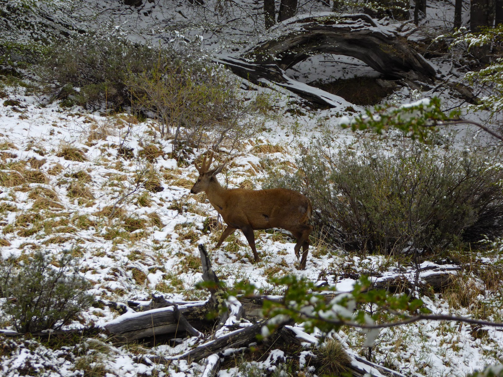
We took the (expensive) bus from Puerto Natales to the park entrance to pay the (expensive) entrance fee. The weather was pretty bad - grey and snowing lightly - and it was recommended to go west-east as there wasn't much chance of seeing the Torres in the east. Unfortunately, we'd booked our refugios to go the other way round, so we took an (expensive) shuttle bus to the start of the trail. We walked through the snow to the Refugio Chileno where we left our bags and continued up to the base of the Torres which, predictably, were hidden in the low cloud. The day was brightened by coming across two of the critically endangered (1500-2000 remaining) huemul deer, making a perfect Christmas card picture.

A huemul deer - there are only 20-100 in the national park
On the second morning we saw that the Torres were still covered in cloud, so we decided not to make the 4 hour round trip up to them again, and instead returned back down the valley towards Lake Nordenskjöld. We were able to enjoy the weather beginning to clear as we walked with the aquamarine lake to our left and the cordillera to our right. The colours had dramitcally changed from a black and white film yesterday to technicolour today. Our second refugio was at Los Cuernos (The Horns), named after the nearby distinctive grey granite peaks topped with a stripe of black rock. Our third day took us past the Cuernos into the French Valley. This was our favourite day of the trek - the steep valley passes the Glacier del Francés, where you can see avalanches of ice falling towards the valley floor, and continues to an amazing viewpoint surrounded by mountains and spires of rock. The return from the valley takes you back past these mountains and the glacier, back towards the bright blue lake.

At the top of the Valle Francés
After the valley, we continued through a section of skeletal remains of trees that were burnt in a forest fire in 2011-12. It was started by a hiker and burned around 176km² of the park. There are now strict rules about fire use - there are no fires or stoves allowed on the trails and you are only allowed to cook inside when at the refugios or campsites. Despite the lack of green trees, there are still fantastic views of the mountains reflected in the still lakes.

Los Cuernos reflected in Lake Sköttsberg
Our final two days took us from the Refugio Paine Grande up to Refugio Grey and back again. This walk takes you along the banks of Grey Lake, with icebergs floating in it which have fallen from Grey Glacier. It was a fitting end to the trek to emerge from the forest and see the glacier stretching across the lake in front of you.

Glacier Grey
On the final day, we took the (expensive) catamaran back across the lake to the starting point for our (expensive) bus back to Puerto Natales to relax for a couple of days. We are now returning to Argentina to meet Jo's family for a couple of weeks of trekking around El Calafate and El Chaltén.

Leaving the park, we finally got to see the Torres!
The granite spires in the centre of the photo.

Monday, 12 October 2015

The Third Highest Waterfall in the World

After leaving the mountains of Huaraz, we continued zigzagging north through Peru. This first took us to some ancient ruins near Trujillo on the coast then, back in the sierra, to Chachapoyas, with more ruins and the third highest waterfall in the world.

The foot of the Gocta Waterfall - note the tiny people!
We wanted to visit Trujillo as it is close to the UNESCO site of Chan Chan. This was the capital of the Chimu culture that was built around 850 CE. It consists of ten huge citadels, although only one has been restored enough to be worth visiting. As the culture lived by the sea, the walls are covered in designs of fishing nets, fish and sea birds.

Fishing net decorations on the walls at Chan Chan
The highlight of the area around Trujillo was some other, earlier, ruins from the Moche culture (approx CE 100 - 800). Now called the Temples of the Sun and Moon, they are two massive pyramids that are still being excavated. Only the Moon temple can be visited, and the excavations have revealed, amazingly, still intact wall paintings.

Painted walls at the Huaca de la Luna
Continuing on to Chachapoyas, we climbed back up into the mountains to see some more ruins - those at Kuelap. This is an enormous fortress that, like Machu Picchu, is on top of a mountain, giving it fantastic views of the surrounding area. It's the largest pre-Colombian structure in the Americas, with huge outer walls 20m high. The construction was begun in 600 CE by the Chachapoyas culture, and was later occupied by the Inca. It's a fascinating site, and many of the remains are still covered by cloud forest. In fact, Chachapoyas is a Quechua word meaning 'cloud forest'.

Trees covering the ruins at Kuelap
Also close to Chachapoyas are a series of incredibly tall waterfalls. We visited the one at Gocta, which is claimed to be the third highest in the world at 771m. It's an astounding sight seeing it from a the nearby village, then getting closer and seeing the water turn into mist as it falls.

On the way to the Gocta waterfall
We're now heading back south towards Lima, breaking up the journey by visiting some more ruins along the coast.