Showing posts with label Incas. Show all posts

Saturday, 28 November 2015

The Best City in South America?

After a few days in Guayaquil sorting out our Galápagos trip and replacing things after our bag was stolen, we moved back up into the mountains. The city we chose for Jo's birthday was Cuenca - an old colonial city dating back to 1557.

The New Cathedral in Cuenca
We found the UNESCO-listed centre to be very beautiful, with plenty of old buildings, churches, cathedrals and plazas. The full name of the city is Santa Ana de los Cuatro Ríos de Cuenca, as it is built around four rivers. This really added to the charm of the place - they were fast flowing and lined with trees and clean banks of grass.

One of Cuenca's four rivers
The route between Guayaquil and Cuenca passes the Cajas National Park. On the way there, we couldn't see any of it as fog limited our visibility to a few metres at most. It also limited our driver's visibility, but that didn't stop him. We decided to return to the park a few days later and had been recommended a day hike to do. It was our first experience of the páramo - high altitude grassland. There were a surprising amount of flower and plant species in a seemingly invariable landscape. Our trail took us to the top of a very steep mountain, eschewing the usual switchbacks and leaving us to almost climb up some parts. The views at the top of the many surrounding lakes made it worth it though.

Lake Toreadora in El Cajas National Park
On Jo's birthday we went for a day out at the zoo. We'd heard good things about it and it wasn't like a normal zoo. Instead of having free reign to go wherever you wanted, it was more like a hike on a predetermined route up a hill around the large animal pens. It was great seeing spectacled bears climbing trees that didn't appear big enough to support them, pumas, ocelots and lion cubs, even if they weren't in the wild. We also went out to one of Ecuador's most famous restaurants - Tiesto's - for an excellent tasting menu with Chilean wine. We weren't brave enough yet to try the Ecuadorian variant. Another treat was staying for a few days in a hotel in one of the historic buildings in the city centre.

A spectacled bear high up in a tree
Another site of note near (-ish) to Cuenca are the Inca ruins at Ingapirca. The Inca empire had extended all the way through Ecuador, but many sites had been destroyed during their civil war, and more after that to prevent them falling into Spanish hands. Ingapirca is the largest site in Ecuador and, although not as extensive as those in Perú, still showed off the amazing Inca architecture. We also enjoyed seeing an 'Inca Face' appearing in the rocks in a nearby cliff.

The Inca Face
To answer the question as to whether Cuenca is the best city in South America - well, it's hard to say. It's certainly one of our favourites, alongside Arequipa in Perú and Sucre in Bolivia. Obviously, though, everywhere is different and we have so much more to explore - starting with the Galápagos Islands, our next destination.

Wednesday, 9 September 2015

Trekking to Machu Picchu

A few weeks ago, after hearing about the less-visited Inca ruins at Choquequirao, I looked at my map and saw a very wiggly, mountainous trail that continued on towards Machu Picchu. I remember saying 'that looks ridiculous'. We've just returned from hiking that trail, and the 8 days it took have been some of the hardest, and most rewarding, trekking of our lives. There was very little walking on the flat, and relentlessly steep descents and ascents into and out of canyons:


Day 1: down 800m;
Day 2: down 700m; up 1500m;
Day 3: explore Choquequirao ruins; up 300m; down 500m;
Day 4: down 700m; up 1100m;
Day 5: up 1300m to 4150m San Juan pass; down 700m;
Day 6: up 1100m to 4660m Yanama pass; down 1800m;
Day 7: down 700m;
Day 8: up 500m; down 500m;


The main square at Choquequirao
We'd chosen this trek to avoid the crowds on the other trails in the area and we weren't disappointed. On the first couple of days we saw just a handful of people making their way to, and from, the Choquequirao ruins. We felt privileged to have this remote hilltop city to explore almost to ourselves. This site is also host to the unique 'Llama Terraces' - white stone depictions of llamas making their way up the dizzyingly steep hillside. We were also lucky enough to spot a condor soaring past.

Llamas climbing up their steep terrace
Nobody else continued on past Choquequirao as we did though - we didn't see any other hikers until day 7. This part of the trek contained some of the hardest days - clambering up to passes above 4000m in both sun and snow. The views (when it was sunny) were incredible - of adjoining canyons bordered by mountains topped with glaciers. On one day we also had the unforgettable experience of camping on Inca terraces, looking down to a foaming river far below.

Camping on Inca terraces
On the 7th day we joined the more popular Salkantay trek and were dismayed at the large groups going the same way as us. We managed to find more solitude on the final day, however, when we left at 4:30am to climb to some more Inca ruins at Llactapata. This gave us our first view of Machu Picchu, on the neighbouring peak, although it still seemed a long way away. From there, we made our final descent of the trek, where we had lunch while waiting for a train to take us the short distance to Aguas Calientes - the (tourist trap) entrance town to Machu Picchu.

Our group at the end of the tough, snowy, ascent to the Yanama Pass
During our trek, we were accompanied by a mule train that carried tents, food, cooking equipment and spare clothes for us. It was hard enough with this assistance; it would have been absolute torture to have attempted it without. We were also joined by two amazing chefs - they prepared miraculous food throughout, given that we were camping and they only had two gas hobs to prepare it on. It would have made chefs in many restaurants in Cusco jealous.

Our mule train crossing a stream near Choquequirao
Machu Picchu itself more than lived up to expectations. It's an amazing feeling to see the view that is instantly recognisable across the world. As predicted, it was incredibly busy during the morning, despite getting one of the first buses into the site. After we were given a tour of the main points of interest though, we found a quiet place to have some lunch and read for a while before venturing back. This proved a good strategy as by the afternoon many people had left and we had a much more relaxed time exploring the rest of the ruins.

The culmination of our journey - Machu Picchu
We thought that we'd had the end of hard trekking, but had decided to ascend the mountain behind the city, Machu Picchu mountain. This was another hour of climbing up steep steps, but the view from the top was worth the pain. As well as a fantastic look at the city, it gave a great perspective of its precarious perch atop the famous ridge, surrounded by steep cliffs, glaciers and other mountains.

Machu Picchu from the top of Cerro Machu Picchu
We feel we've had a good introduction to the Inca civilisation now, following our time in and around Cusco, and we're now going to head back down towards the coast and another ancient civilisation - the Nazca and their famous Lines.


Sunday, 30 August 2015

Cusco - Historic Inca Capital (And Tourist Capital Of South America)

We took a nightbus from Arequipa to Cusco, where we've spent the last five days. Although best known as the tourist hub for the thousands of visitors that flock to Machu Picchu each year, it is also a fascinating place in its own right, with some amazing Inca sites to check out in the city and surrounding area.

Inca walls in Cusco
Cusco was the capital of the Inca empire, founded in the 13th century. It's now a world heritage site and is an interesting mix of Incan and colonial architecture. Inca walls built with huge blocks of stone line many of the streets; the blocks, despite being all shapes and sizes (one is 12 sided!), fit together like a jigsaw so well that you cannot see any sign of mortar holding them together. Alongside the Inca features, you see plenty of evidence of the Spanish conquest - the main square with its Catholic cathedral and Jesuit church, for example. Despite being full of tourists, it's a beautiful city and we've enjoyed exploring it.

The cathedral in Cusco's main square
On our second day here, we met up with our German friends from the Colca Canyon and took a bus out to Tambomachay, one of four Inca sites within a few km of the city. We walked back, taking in all the other sites and managing to avoid tour groups in the main. The largest of these sites is Sachsaywaman ('sexy woman' is the best way to remember the name!), which was an enormous fortress guarding Cusco. Some of the stone blocks here were simply gigantic - the largest weighed around 300 tons. It's hard to imagine how such might could have fallen to a Spanish force of around 50 horsemen.  

The Inca ruins of Sachsaywaman
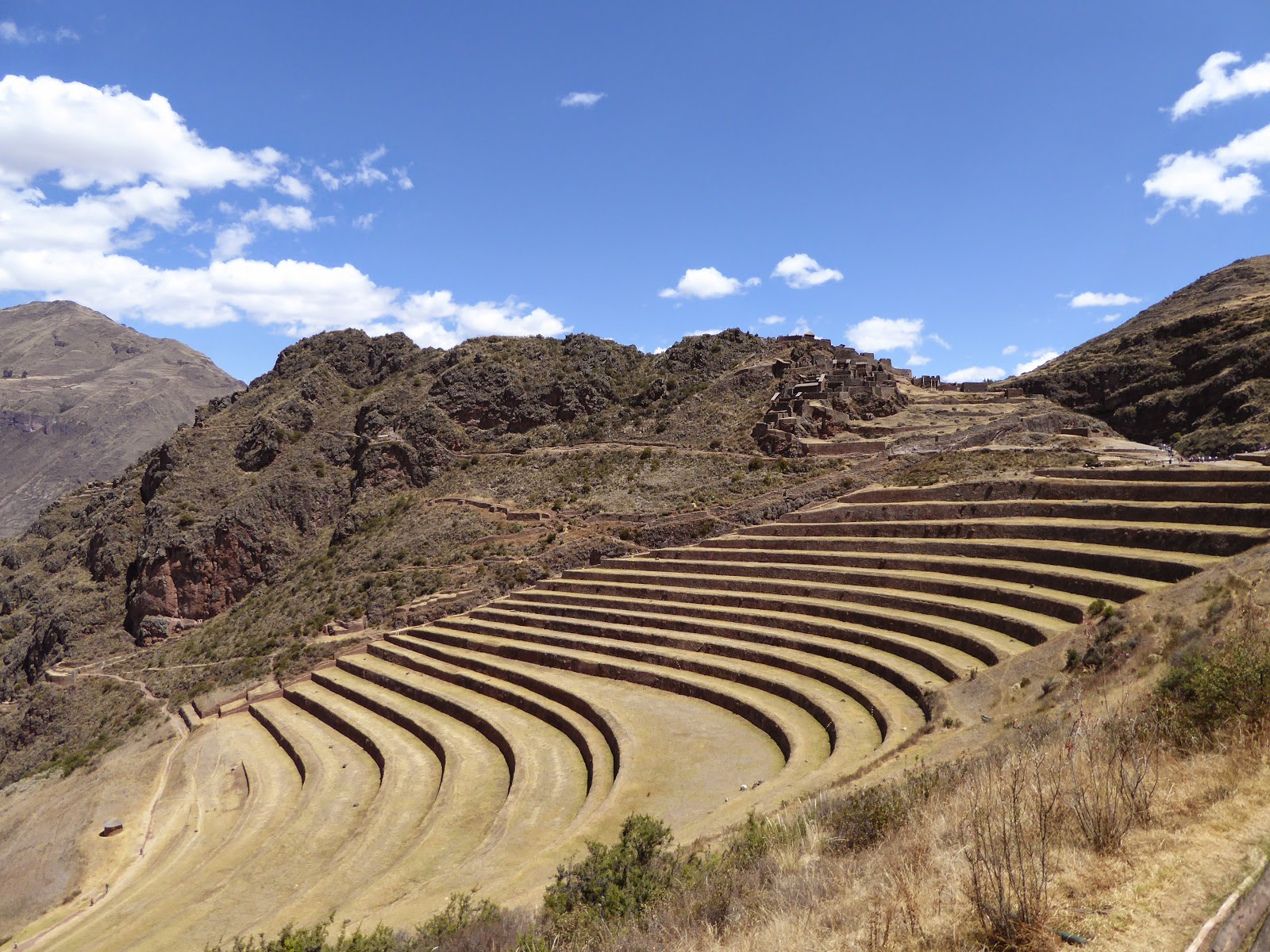
Other Incan ruins around Cusco include those at Pisac, an insanely touristy town nearby. We took a taxi up to the ruins from the town centre and were dismayed to find at least twenty tour buses outside, while inside were umbrella carrying tour guides and megaphones galore. Fortunately most groups seemed to be on their way out, so within an hour or so we had the place almost to ourselves. The site is a citadel and small town, with impressive agricultural terraces carved out of the steep hillside right down into the valley.

Inca terraces at Pisac
We saw more agricultural terraces at Moray, another Inca site nearby. The terraces here are unusual in that they are deep and circular - very striking. Research has shown a temperature variation of 15°C or more between the top and bottom, and it seems that the Incas used the area as a kind of laboratory to test the effects of different microclimates on crops.

Circular agricultural terraces at Moray
Perhaps my favourite of all the sites we visited here was the salt pans or Salinas near the village of Maras. This is a set of several hundred rectangular ponds on several levels, into which salt water flows from a subterranean source and evaporates to form salt. The view from above is quite stunning - a patchwork of rectangles, punctuated by local people harvesting the salt in buckets and bags. The pans vary in colour depending on how long they've been evaporating, from brown to sparkling white. You can walk across the whitest ones, which reminded us of the salt flats in Bolivia.

The Salinas (salt pans) near Maras
While in Cusco we've met up with several friends from the last couple of weeks in Peru. It's been lovely catching up over craft beer and pisco sours. Most of these have already visited Machu Picchu, but we have decided not to rush things... Instead we have booked ourselves on an epic 9 day trek to get there! We leave tomorrow and trek first to Choquequirao, another Inca city, before heading onto Machu Picchu. We look forward to telling you all about it in ten days time...

Monday, 24 August 2015

Arequipa and Trekking the Colca Canyon

We've spent the last few days sightseeing in the old colonial city of Arequipa before getting out of the city for some trekking in the nearby (only 6 bus hours away!) Colca Canyon.

The cathedral in the main square in Arequipa
Arequipa - more Jesuit churches
Arequipa itself has a very pretty centre, mostly constructed from sillar - a white stone taken from the three volcanoes overlooking the city. There are ornate churches, a huge cathedral and a frozen mummy of a 12 - 14 year old girl called Juanita. It felt a lot like Sucre, in Bolivia, to us. Apart from Juanita.

Juanita was an Incan sacrifice to one of their mountain gods. It would have been a great honour to her to accompany the priests to the freezing summit to offer herself to appease the gods that were causing the nearby volcano to erupt. Preserved in nearly perfect condition she was found in 1996, ironically due to another nearby volcano erupting and melting her icy tomb. She has been on display ever since, and it's a very moving experience to come face to face with her in the museum.


One of our favourite things was spending an afternoon wandering around the picture-perfect Santa Catalina Convent. The convent occupies a whole block in the city and has its own interior streets and cloisters - a quiet island cut off from the busy streets outside. It was constructed in 1579, and there is still a section where a few nuns live in seclusion today, as in days gone by.

The quiet streets of the Santa Catalina convent
Running through Arequipa is the Chili River, which is well known for its whitewater. We spent half a day on the river - Jo for her first time in a raft and me kayaking. We both really enjoyed it - the rapids were continuous class III with little respite, with a class IV in the middle. It was great for me to be back in a kayak on whitewater again, for the first time on this trip, and Jo found the raft to be a good level of fun and fright.

Running the Chili River
From Arequipa we made our way to the Colca Canyon, the second deepest canyon in the world. The deepest is another few hours away by bus, and is very difficult to explore properly without paying a lot of money for a tour and a guide. The Colca Canyon is a lot more visited by people doing day trips from Arequipa to a great viewpoint for seeing condors. We skipped this, and continued further along the road to get closer to the canyon.

The Oasis of Sangalle at the bottom of the Colca Canyon
We spent three days trekking. The first was spent gradually descending down the steep wall to Llahuar where we were rewarded with (almost) hot springs to soak our aching muscles. There, we met a great group of people to continue for a full day along (with a lot of up and down) the Colca River at the base of the canyon to San Juan de Chuccho. From our basic lodgings there we could see the daunting ascent for the following day - we'd be climbing over 1000m back up to the trek's starting point. We hadn't anticipated that the bit we could see would be the easiest part of the climb - it turned out that part only took an hour. The next two hours were even steeper and we were exhausted by the time we reached the top.

Our smiling group, before the exhausting ascent
We did make the top in time to catch the bus back to Arequipa. Perhaps 6 hours in a bus isn't the best thing for stiff legs after such a climb, but we're moving on again and will take a night bus tonight to the heart of the Inca empire - Cusco.

Sunday, 16 August 2015

From Bolivia Into Peru - Lake Titicaca From Both Sides of the Border

We left La Paz wishing we'd had a bit more time there, but also excited about the thought of a new country before too long. First, we wanted to stop in Copacabana, 7km from the Peruvian border, to see Lake Titicaca and Isla del Sol.

Our bus to Copacabana - it got on its own little boat for some of the way!
We decided to treat ourselves again in Copacabana as we'd heard great things about a rather unusual hotel there, Las Olas. The hotel is made up of several 'suites' that are in fact little freestanding houses, all with very quirky designs. Our suite was the Sea Tower, three floors high and with a fantastic view of the lake from our top tower room. All the floors were circular and we even had a specially designed circular bed! We also had a little fireplace, which kept the place cosy during the freezing Copacabana evenings.

Our Sea Tower home in Copacabana
Lake Titicaca is the highest navigable lake in the world at 3800m, and even before arriving in South America we'd intended to stay a night on its largest island, Isla del Sol (the Sun Island). However, it turned out this was not meant to be. Having been talking in La Paz about how we always have good luck with the weather, we appeared to have jinxed it... Storms, heavy rain and snow put paid to any plan to head across the lake by boat. The first time either of us have seen snow in August!

The Basilica of Our Lady of Copacabanca, in a very grey Copacabana
Despite the weather, we still enjoyed our time in Copacabana. We visited the town's basilica, which is very grand - completely out of proportion to the size of the town! The church contains a famous 16th century icon of the Virgin of Copacabana, the patron saint of Bolivia, who is traditionally worshipped on the 5th August. Although we were there a week later there were still queues and queues of vans and buses arriving from across Peru and Bolivia to see the icon. We also managed between snow showers to climb the steep hill behind our hotel, for a wonderful vista of Lake Titicaca and the town spread out below. This hill was another pilgrimage site, with stone crosses marking the stations of the cross and another icon at the top. Sadly though, everywhere was completely strewn with litter after a lot of people came up here for the festival on the 5th.

Looking down on Copacabana and Lake Titicaca
We decided not to waste any time waiting for the weather to improve and after two nights in Copacabana took a bus over to Puno, in Peru. Puno is also on Lake Titicaca and is the main entry town from the Peruvian side, so there are a LOT of tourists here! Quite a shock for us. On the plus side however, we have already noticed a dramatic improvement in the food here compared with any of the previous countries. It's great seeing dishes with sauces, spices, herbs... we are feeling quite positive about Peruvian cuisine!

The beautiful Lake Umayo, at Sillustani
Near Puno there is an interesting archaeological site at Sillustani; it is a hillside scattered with 'chullpas' - huge funerary towers or urns varying from around 4 to 12 metres in height. These stone, cylindrical structures were used as tombs by pre-Inca cultures from this region and then by the Inca themselves, dating from around the 12th to the 15th centuries. They are now in varying conditions, with some remaining almost perfect and others reduced to piles of rubble. There were other remains to see, including stone circles used by the Inca for sacrifices. The complex is in a beautiful location, on the shores of Lake Umayo where we even saw a couple of flamingoes.

Local ladies sitting outside one of the Inca chullpas
While in Puno we also paid the mandatory visit to the Uros Islands, which are artificial islands built entirely of reeds. Despite taking a ferry rather than taking a tour, the experience was still massively touristy - think floating souvenir shops. However, it was still worth doing to learn how the islands were built and to see what life is like for people living in such an unusual place. The islands are tethered but still move slightly with the wind and with the movement of people walking around; it felt a little like being on a boat.

Uros islands - reed islands in Lake Titicaca, near Puno
We are leaving Puno tomorrow for Arequipa, Peru's second largest city, and renowned for its cuisine.


Wednesday, 12 August 2015

La Paz - Not As Scary As You Think

We arrived in La Paz having heard tales of people kidnapped in taxis, fake police officers, bag snatching, etc. However, with a bit of common sense (don't just get in any old taxi, police officers should be wearing uniform...) we felt perfectly safe. We were staying in a more upmarket area called Sopocachi, outside of the traditional backpacker district, with plenty of good restaurants in the area. Unfortunately, we didn't get to try many of them - our visit was tainted by another bout of food poisoning.

The cable car descending into La Paz from El Alto
Having recovered after a day shuttling between the bed and the toilet, we braved going on a walking tour in the city centre. Although there weren't many stand-out sights, La Paz is a fascinating city to explore. It is situated in a deep valley, surrounded by snowcapped mountains, with buildings lining the vertiginous sides. Atop one side of the valley is a plain on to which the city extends; it has now been designated as a separate city, El Alto - the highest city in the world (4,150m). Lots of parks have great views across the valley. Unfortunately, they were all designed by an evil genius. Inviting looking paths wind down a cliff face, only to leave you at a high fence, with the next path that you want visible beyond, but inaccessible so there is no way to go but back up the cliff. There are also plenty of markets in the city, including the famous witches' market where you can buy love potions and llama foetuses among other outlandish things.

One of the parks in La Paz, with fence-lined paths
La Paz and El Alto also have significant, if not majority, indigenous populations. The Aymara women in particular have a very distinctive fashion with long, wide skirts and brightly coloured shawls, topped with a too small bowler hat. These were introduced by the British when building the railways, and soon became an integral part of the culture. Unfortunately for us, it's not the done thing to take photos as they believe it steals part of their soul.

Buildings lining the valley wall up to El Alto
We spent one day outside of La Paz to see the UNESCO site at Tiwanaku. The Tiwanaku culture dominated the region for around 2000 years before the Inca arrived in the 15th century. We visited one of their largest religious sites, close to Lake Titicaca. It was mostly destroyed by the Spanish colonialists, but excavations have revealed grand pyramids, statues of heads protruding from subterranean walls and giant monoliths. It was a fascinating trip to see something of a less-celebrated, but no less influential, culture than the Inca.

Faces inset into the wall in Tiwanaku
We are coming to the end of our time in Bolivia now - we have a final stop in Copacabana on the shore of Lake Titicaca before heading into Peru.


Thursday, 30 July 2015

Exploring Inca Ruins Around Samaipata

After the Missions circuit, we decided to spend a few days away from the heat of the lowlands, in the higher valleys around Samaipata. This is a small village, but has become popular with tourists recently, particularly the hippy crowd.

The square in El Pueblito
We stayed in a small resort, as a bit of a treat to ourselves, outside the town on a hill with a wonderful view of the town and valley below. It's called El Pueblito, or Small Town, and is designed like a traditional village with themed rooms set around a central square. Our room was styled as a florist's, which meant fresh flowers and garden tools adorning the walls. Although slightly kitsch, it was something a bit different and a great place to relax.

Our room - the florist's - in El Pueblito
The main draw in the area is a UNESCO world heritage archaeological site known as El Fuerte, The Fort. It consists of a large rock protruding from a hilltop, used by the Inca and earlier cultures for religious carvings and ceremonies, and the accompanying village ruins. When the Spanish arrived, it had already been abandoned for some time, and they presumed it had been a fort, hence the name. Later research into the carvings on the rock suggests that it was of more religious significance; carved jaguars and pumas were symbols of power, while several large niches in the rock are thought to have held idols or mummified ancestors.

El Fuerte de Samaipata
We have now returned to Santa Cruz once again, before flying to Rurrenabaque in the remote north of the country for our first experience of the Amazon rainforest.

Tuesday, 9 June 2015

La Serena and Pisco Tasting in the Elqui Valley

La Serena is the main town of the Norte Chico region of Chile and the scenery during our seven hour journey here was a dramatic change from everywhere else we've been so far - arid, desert-like landscapes, with few plants other than cacti of all shapes and sizes. The temperature is noticeably higher during the day, getting up to the high 20s, but drops a lot at night.

The arid Elqui Valley, near to La Serena
We were lucky to hit gold with our choice of hostel here. La Sombre del Viento, a recently opened place, was more like a boutique hotel than a hostel! We had the best shower of the trip and homemade yoghurt, bread and cake for breakfast every day. Our French host, Marie-Laure, was incredibly welcoming and happy to chat to us about her travels across the world over a pisco sour. We told her she could easily charge a lot more - but she doesn't want to attract only the rich customers. Awesome.

The wonderful hostess Marie-Laure, and her world travel map
We spent our first couple of days here checking out the highlights of the city, namely the Japanese garden and the Archaeological Museum where exhibits included one of the original Moai statues from Easter Island. We also decided to visit the nearby Valle del Encanto (enchanted valley), which is famous for its rock art and archaeological importance. Tour agencies in La Serena offer this trip at exorbitant prices, but we opted to go instead under our own steam. After two hours on two different buses we set off walking the final 5km in the baking heat, but luckily were picked up halfway by a friendly Chilean guy who turned out to work there! The rock art was really amazing, with a mix of petroglyphs (carvings), pictographs (paintings), and also lots of hollowed out depressions in the rock, possibly used to mix paint in. There were also two enormous, 3m wide holes, which were labelled as 'Baños del Inca' - baths of the Inca - although we're not sure how accurate this name is. Most of the art came from the early centuries AD, but they have also found evidence of human habitation here up to 5000 years ago.

Jo and a Moai Pictographs in the Valle del Encanto
After three days around La Serena, we took a bus into the Elqui Valley and stayed one night in the picturesque, if very backpackery, village of Pisco Elqui. Pisco, a spirit distilled from grapes, is Chile's speciality and we've had many a pisco sour here - a delicious cocktail made from pisco, lemon juice, sugar and egg white. Most production of the spirit happens in the Elqui Valley and we enjoyed the long bus ride there with spectacular views of the valley far below, enclosed by steep cliffs and patterned with vineyards. While in Pisco Elqui we obviously had to try some, so did a short tour of the Mistral distillery (one of the premium brands of pisco), including two tastings.

Pisco tasting in Pisco Elqui
We've just survived a gruelling 16 hour bus journey to arrive this morning in the desert town of San Pedro de Atacama, which is literally in the middle of the Atacama Desert! More on that next time.