Showing posts with label colonialism. Show all posts

Thursday, 2 June 2016

The Biggest Bird You'll Ever See?

We'd seen several condors before on our trip, most notably during our trek towards Machu Picchu and several around El Chaltén, but never close enough to really appreciate their size. This time, while walking early in the morning, all alone in the Quebrada del Condorito national park, we saw two figures on a nearby hill. At first, we thought they were two more people, detracting from our uniqueness, but then they spread their wings and took off! They were enormous. They can have a wingspan of up to 3.3m and weigh up to 15kg.

Condor flying overhead at Quebrada del Condorito
This wasn't our last encounter with condors for the day. When we reached the quebrada (canyon), we saw several more circling overhead and some landing on the opposite cliff. Then, a group of about 15-20 decided to pass right above us before flying into the distance. It was an incredible experience to see them swoop over us one by one before disappearing behind the mountain.

The Quebrada del Condorito
The national park was our highlight of our time in and around Córdoba, Argentina's second city. We liked the city itself - it's an old colonial city and is home to our final World Heritage Site for Argentina. Of course, it was another Jesuit mission. We did a short tour around the church, and discovered that the surrounding buildings are home to the country's oldest university. As a major university city, it was home to many of the 'Disappeared' - those who were killed by the military dictatorship during the '70s and '80s.

The entrance to the Jesuit church
After a lot of time sitting in cars and wine tasting, we wanted to do some hiking, and handily there are several small mountain ranges just outside Córdoba - the Sierras. We visited the small town of Capilla del Monte in the Sierras Chicas (Small Sierras), home to Uritorco Hill. This was perfect for our needs - a day long hike with pleasant views over the town and the nearby reservoir. Before we arrived, we hadn't done much more research than that, and we soon found that the town is full of UFO spotters, 'magical' rocks and plastic pyramids full of 'mysteries'. In 1986, a scorched patch of ground was found and this was subsequently blamed on aliens. You can now watch some incredibly unrealistic videos online, or buy plenty of little green man dolls.

A 'mystical' pyramid in Capilla del Monte
After Córdoba, we set off for our final country on this continent - Uruguay. We'll stop in a couple of places on the way to break up the journey, but not spend much time there, before crossing the border to Fray Bentos.

Monday, 21 March 2016

A Very Smelly City

We departed Curaçao late in the evening, after a great few days there. As we mentioned previously, one of our main reasons for visiting was to use it as a stop off point between Colombia and Guyana, thus avoiding Venezuela. We found there was a cheap daily flight from Curaçao to Georgetown, the Guyanese capital, with InselAir.

Georgetown, viewed from the air
What we didn't realise when we booked this flight, was how notoriously bad InselAir is. As it is one of the only carriers offering short hops around the Caribbean and the north coast of South America, it has a bit of a monopoly. It seems this means it can run its flights whenever it wants, and the scheduled times mostly bore no resemblance to the actual departures!  Our flight was meant to leave at 9:30 pm, the last of the evening from Curaçao. It actually went at 11:10 pm, from a different departure gate. The time and departure was announced suddenly - up till then we'd heard nothing about it. We were quite fortunate it seems, as three other InselAir flights scheduled to leave before ours had not even arrived when we were boarding. Art, our host in Curaçao, told us the InselAir flights are always like this!

St George's Cathedral, in Georgetown
Anyway, we eventually arrived safely in Georgetown at 1am. We had been a little worried that our taxi pick up would not be there, or the driver would be an axe-murderer (safety is quite an issue in Georgetown, especially late at night). However, all went smoothly. Other than the fact that the airport is not in fact in Georgetown but out in the jungle nearly an hour's drive away... hence it was full of moths. BIG ones. Like, the biggest moths I've ever seen, all at once. It was a complete nightmare for me, and when we got in the taxi and there was one inside, I nearly had a heart attack! Luckily, once in the city, moth sizes / numbers became a lot more manageable.

Interior of St George's Cathedral
Guyana is probably the least well known and the least travelled country in all of South America. This little nation, with a population of only 750,000 people, used to be a British colony and only became independent in 1966. The British influence is evident in several respects: the official language is English (it's the only country on the continent that speaks English as its first language), they drive on the left hand side of the road, they are passionate about cricket, and they are fond of tea (in teapots). Oh, and the local beer, Banks Beer, first brewed while Guyana was still a British colony, is probably the best national lager we've had in South America. The country is also very multicultural - another legacy of the British, who brought slaves over from Africa and indentured labourers from India. The largest ethnic groups today are East Indian and African. It is the poorest country in South America, behind Bolivia and Paraguay, and the local currency is the Guyanese dollar, of which there are about 300 to a pound. It's quite entertaining when you hear that your dinner will be 1000 dollars! Given that it is so poor, it seems strange how expensive it is - just a few days here will severely dent a backpacker's budget, we found out.

The City Hall in Georgetown
When we arrived in Georgetown itself, the first thing that hit us was the smell... not in a good way! The city has open sewers, is very dirty, and all water channels / rivers are literally black. Everywhere stinks of poo. However, we got used to this fairly quickly! Georgetown also has a reputation for being unsafe, as I mentioned - there is a high incidence of petty crime and certain areas are definite no-go zones for tourists. We were a little nervous at first to just walk around on our own, but our host said it would be fine, so we spent a lot of time just strolling round the city absorbing the atmosphere. We had no problems at all; in fact. on the contrary, people were mostly pretty friendly and curious to see white faces. While Georgetown has quite a gritty feel to it, we enjoyed it, as it is just so completely different to anywhere else in South America. It was great seeing Asian shops everywhere, hearing English spoken (albeit in a Caribbean accent we often couldn't understand!), watching cricket with locals, and hearing Indian-influenced styles of music.

The 1763 Monument, in Revolution Square
We explored the city over 2 days. There aren't many attractions, but the huge wooden cathedral, St George's, was quite impressive. It is apparently the largest wooden church in the world - the locals are quite proud of this! We also visited the City Hall, another colonial wooden structure, decaying somewhat but still very nice; the National Library; and the National Museum. The museum's main exhibition was about Guyana's big festival here, Mashramani, which takes place in February every year to commemorate the anniversary of the country becoming a republic. The photos and costumes on display, and the excitement of local people when discussing this, suggested this country does have one thing in common with the rest of the continent - it loves its carnival! Another day, we walked over to Revolution Square, where there is an interesting African themed memorial to a slave revolt that took place here in 1763. Passing the Botanical Gardens and Zoo en route here we randomly saw two beautiful macaws flying right overhead, reminding us just how close to the jungle Georgetown really is.

Old fashioned adverts lining Georgetown's sea wall... They even had a Marmite advert!
We had planned to go straight from Georgetown over the border to Suriname. Suriname is the only country for which we need a visa - well, a 'tourist card' for us as UK citizens. The process of applying for this was a little complicated. First we had to go to the Surinamese embassy, which was cunningly concealed in a posh residential area of Georgetown. We spent a while walking around looking for it, and eventually located it with the help of some locals. The security guard at the embassy asked us, did we have a photocopy of our passport photo pages? Forewarned about this, we said yes. Did we have a photocopy of our Guyana entry stamp page? Erm, no. Did we have 35 US dollars each? Erm no, but we had $25, which was what it had cost last week. The lady packed us off to change some more Guyanese dollars into USD, and get the other photocopy. We later found out the charge for the tourist card had gone up only 2 days ago - doh!

Aerial view of the jungle near Kaieteur Falls
When we returned to the embassy with all we needed, the security lady finally let us into the office itself. The lady at the desk there told us we'd need to leave our passports and come and pick them up again that afternoon. We couldn't do that, we said, as we had a tour booked that afternoon. We asked if we could come back the following morning instead (Friday). Well, the office MIGHT be closed, she said, as there MIGHT be a national holiday. Could she find out, we asked. No, no-one knew, apparently. There were some local elections happening and the embassy staff didn't yet know if they'd be working or not! We grew steadily more frustrated as we knew the embassy would definitely be shut at the weekend. Eventually we pestered her enough that she managed to get our tourist cards issued straight away! Not sure why you normally have to wait until the afternoon...

At Kaieteur Falls
The reason we couldn't go back to the embassy that afternoon was that we had booked ourselves on a trip to Kaieteur Falls, perhaps Guyana's most spectacular natural attraction. The majority of the country is pristine jungle (well, with the odd gold mine), and the Kaieteur waterfall is deep in the interior, hidden in the rainforest. The only option for getting there, other than a 5 day hike, is a short flight in a small 12 seater plane. It was an expensive tour, but 100% worth it! We flew for an hour over a sea of trees, seeing nothing but this huge expanse of green for miles and miles, interrupted only by the muddy brown rivers snaking their way across the country. As we neared our landing point, the pilot made a big turn, and we had our first sight of the Kaieteur Falls. Wow!

The beautiful Kaieteur Falls
We landed at an airstrip literally in the middle of the jungle, and had 2 hours on a guided walk that took us to three different viewpoints of the falls. It has to be one of the most spectacular in the world, not just for its size (the highest single drop waterfall in the world) but for its stunning setting. The waterfall drops from a rocky outcrop, and all around is rainforest. The power of the water was incredible, even though our guide told us it was currently only about 60% full due to the recent dry weather. In the mist around the falls we could see rainbows. I'm so glad we made it here, as it was really something special. We didn't want to leave, and wished the other tourists who accompanied us on the flight would stop taking photos occasionally so we could just gaze in peace for longer!

Rainbows in the mist
While there is doubtless plenty more to see and do in Guyana, chiefly jungle-based adventures, we are trying to push on through these three little countries at the top of the continent. The prices here are high, and we still have a lot more to squeeze in before we return home in June. So for now, it's goodbye Guyana, as we head on to Suriname (a gruelling 12 hour bus-boat-bus-bus journey, more on that next entry!)

View down the valley from the bottom of the falls

Monday, 7 March 2016

Guerrillas in the Mountains?

Until quite recently, the area around Tierradentro and San Agustín in the south of Colombia was not the safest due to guerrilla activity. There was an attack on police in September 2014 in Tierradentro and military operations near San Agustín in May 2010. Therefore, when we came across a band of heavily armed men dressed in fatigues while walking on a small path towards the ancient tombs of Tierradentro we felt some trepidation. We're now pretty sure that they were army, though, and we had a nice chat with them about the area, although didn't bring up anything too political!

The path where we came across the army - we obviously didn't try to get any pictures of them!
We'd left the touristy village of Salento for Popayán, one of the larger cities in the south of the country. It's known as the White City (see Arequipa, Perú and Sucre, Bolivia) and lived up to its name, with plenty of colonial buildings and churches lining the streets. We didn't spend much time here, though - we were just using it as a base to get to the UNESCO-listed archaeological sites at Tierradentro and San Agustín.

Popayán - the (a) White City
Not much is known about the pre-Colombian civilisations in this area. All that is left now are underground tombs, particularly in Tierradentro, and hundreds of statues and rock carvings, primarily in San Agustín. They date to the first millennium AD and no-one knows what happened to the cultures that created them - they'd disappeared by the time the Spanish arrived in the 1500's.

A tomb in Tierradentro
The tombs in Tierradentro are situated on four different hilltops around the town of San Andrés de Pisambalá. They consist of a large well of around 5-8m depth which gives access to a cave where bodies were interred in pots. Many of the tombs have no decoration, and many have been looted and damaged. However, some still show colourful, but simple, painted geometric patterns and creepy faces carved into the walls and supporting columns.

Statues guarding a tomb in San Agustín
Although Tierradentro has a few statues, the majority are found at many sites around San Agustín. Again, not much is known about them, but there are many hypotheses as to their meaning. They range from 1m to 7m in height and take on the form of humans, animals and a mix of the two. Some are thought to be gods and others shamans. To our eyes, they appear quite aggressive, with many bearing their teeth and others seeming to represent child sacrifice.

An owl/eagle and snake god?
The town of San Agustín is set in a beautiful location, close to the source of the Magdalena River, which we'd seen before in Honda and Mompox. Here, though, the river was much narrower and raged far below in a deep canyon. We found a good way to visit the river and a number of the archaeological sites was on horseback. This was our first time on horses, and we had a good time sitting on them while they did whatever they wanted!

Jo and her horse, Carmela
From San Agustín, we took a night bus up to Bogotá, which will be our final stop in Colombia before we fly up to the Dutch island of Curaçao for a few days. We're using this as a stop on the way to Guyana, avoiding the currently unstable and dangerous Venezuela.

Monday, 1 February 2016

Injury, Illness and More Diving

When we last left you, we'd planned to be heading off into the jungle for four days to trek to 'Ciudad Perdida' ('Lost City'). However, a couple of days before we were to leave, we were struck down by both injury and illness. I managed to hurt my foot once again - tripping on a loose paving stone in Santa Marta left me with a big cut on my toe and an inability to walk comfortably. Not ideal when preparing for a long, hard trek. Jo, meanwhile, was feeling a bit unwell and this worsened for a few days. Aching joints, mild fever, fatigue and a small rash pointed to zika. This is currently all over the news in Europe at the moment, possibly leading to babies born with microcephaly. Luckily, the other symptoms are generally mild, although don't leave you ready to hike. Therefore, we cancelled this plan and spent the time resting and recuperating in an air conditioned room in Santa Marta.

The town hall in Santa Marta
A plaque for Símon Bolívar in Santa Marta's cathedral
Santa Marta doesn't have much in the way of sights, which was perfect to ensure that we didn't venture out too much. We always try to see as much as we can of a place, so it was something of a blessing that there wasn't much here when we needed to rest and recuperate. We did visit the excellent Museo de Oro (Gold Museum), full of artefacts from the ancient Tayrona culture and information on the history of the city. The cathedral was the first resting place of Símon Bolívar, the Liberator of much of South America from Spanish colonialism, before his body was moved to his birth city of Caracas in Venezuela.


After a few days, we felt we needed a change of scenery and went for a couple more restful days in the hills surrounding Santa Marta. We stayed at a hostel/farm a short bus ride outside of the city, followed by a bumpy motorbike ride up a hill. We relaxed by the pool here while feasting on locally grown chocolate, coffee and honey. We also exerted ourselves more on the last day to climb the steep path up to a viewpoint over the whole of the surrounding countryside, with the city in the distance.

The viewpoint near Finca Carpe Diem
We had been filling up time before returning to Taganga for some more diving and to meet up with our friends from home - Ralph and Shehnaaz. We all stayed in the same hostel as last time, which has a terrace with a perfect view over the bay for sunsets. The main reason we'd returned was for diving. The other three successfully completed their PADI Advanced Open Water course with the same instructor as before - Reto Müller. I had already completed the next certification up, so just joined them for some fun dives. Unfortunately, the visibility was often not great for much of it and the currents were quite strong. This made the conditions quite tough, which I guess is a good way to learn!

Wearing diving t-shirts at Casa Baba
While Ralph and Shehnaaz have continued on to the northernmost point of South America, Punta Gallinas, we are returning to Cartagena to then fly to San Andrés. This is a Colombian island in the Caribbean Sea, close to Nicaragua and supposed to have excellent diving.

Friday, 15 January 2016

Birthday on the Caribbean Coast

We left Pasto to fly up to Cartagena, a UNESCO listed colonial city on the Colombian Caribbean coast. We were going as our friends, Cindy and Julien, with whom we'd travelled in Chile and Bolivia, were going to be there having just arrived from Cuba. It was great to see them again and exchanging tales of our travels in the intervening six months. It was also my birthday and we celebrated with Indian food and craft beer, which I enjoyed a lot!

In the craft beer pub for my birthday
Cartagena was a big change on many levels - altitude, heat, people, music, etc. It was almost the first time on our trip that the climate was actually hot. We'd mostly been in the Andes along the length of the continent, and although the days could be quite warm, the evenings and nights were refreshingly cool. Now, the heat was relentless and we were glad for the air conditioning in the room.

Old and new - skyscrapers and city walls in Cartagena
The other marked differences were the ethnicity and the music being played everywhere. There's a much more racially diverse mix than we've seen in the rest of South America, and the music follows on from that. Although you still hear the same stuff as in the rest of the continent, there's more variety here with a lot of Caribbean influence. It makes a nice change!

The main fort in Cartagena
The city itself was the principal Spanish port and access point to South America in colonial times, founded in 1533. As well as exporting gold and precious metals, many slaves were brought there to work in the colony. This made a significant contribution to the diversity seen today. Now it is a beautiful city, with each narrow street making a picture postcard of flowered balconies and cobbled streets, frequently roamed by horse and carts. It is surrounded by large city walls and looked over by an impregnable castle (the British tried to invade several times and were repulsed on each occasion).

Horse and cart on a typical Cartagena street
Cartagena was linked to the interior of the continent by river to the city of Mompox. This river was neglected in the 19th century, and became silted up, which led to the decline of the latter. However, this has left a sleepy town full of streets similar to those in Cartagena, but without the crowds of people and tourists. We spent a couple of days here, adjusting to the slow pace of life and taking a boat trip through matted reed beds with heron's heads poking out of the top.

The Magdalena River in sleepy Mompox
Since Mompox we've returned to the coast to Taganga - in stark contrast to Mompox, it is a hive of backpackers and cheap diving courses.

Saturday, 28 November 2015

The Best City in South America?

After a few days in Guayaquil sorting out our Galápagos trip and replacing things after our bag was stolen, we moved back up into the mountains. The city we chose for Jo's birthday was Cuenca - an old colonial city dating back to 1557.

The New Cathedral in Cuenca
We found the UNESCO-listed centre to be very beautiful, with plenty of old buildings, churches, cathedrals and plazas. The full name of the city is Santa Ana de los Cuatro Ríos de Cuenca, as it is built around four rivers. This really added to the charm of the place - they were fast flowing and lined with trees and clean banks of grass.

One of Cuenca's four rivers
The route between Guayaquil and Cuenca passes the Cajas National Park. On the way there, we couldn't see any of it as fog limited our visibility to a few metres at most. It also limited our driver's visibility, but that didn't stop him. We decided to return to the park a few days later and had been recommended a day hike to do. It was our first experience of the páramo - high altitude grassland. There were a surprising amount of flower and plant species in a seemingly invariable landscape. Our trail took us to the top of a very steep mountain, eschewing the usual switchbacks and leaving us to almost climb up some parts. The views at the top of the many surrounding lakes made it worth it though.

Lake Toreadora in El Cajas National Park
On Jo's birthday we went for a day out at the zoo. We'd heard good things about it and it wasn't like a normal zoo. Instead of having free reign to go wherever you wanted, it was more like a hike on a predetermined route up a hill around the large animal pens. It was great seeing spectacled bears climbing trees that didn't appear big enough to support them, pumas, ocelots and lion cubs, even if they weren't in the wild. We also went out to one of Ecuador's most famous restaurants - Tiesto's - for an excellent tasting menu with Chilean wine. We weren't brave enough yet to try the Ecuadorian variant. Another treat was staying for a few days in a hotel in one of the historic buildings in the city centre.

A spectacled bear high up in a tree
Another site of note near (-ish) to Cuenca are the Inca ruins at Ingapirca. The Inca empire had extended all the way through Ecuador, but many sites had been destroyed during their civil war, and more after that to prevent them falling into Spanish hands. Ingapirca is the largest site in Ecuador and, although not as extensive as those in Perú, still showed off the amazing Inca architecture. We also enjoyed seeing an 'Inca Face' appearing in the rocks in a nearby cliff.

The Inca Face
To answer the question as to whether Cuenca is the best city in South America - well, it's hard to say. It's certainly one of our favourites, alongside Arequipa in Perú and Sucre in Bolivia. Obviously, though, everywhere is different and we have so much more to explore - starting with the Galápagos Islands, our next destination.

Saturday, 17 October 2015

The Lord of Sipán - The Richest Tomb in Peru

Our next stop having left Chachapoyas was the city of Chiclayo, on Peru's north coast. We took a nightbus here from Chachapoyas, arriving at the antisocial hour of 4 am. It seems that most nightbuses in the north of Peru leave at around 8pm, regardless of the number of hours to the destination, so we've arrived before dawn several times!

Chiclayo is not the most pleasant of cities - it's big, busy and polluted. However, there are several amazing archaeological sites in the area, plus one of Peru's best museums, and we spent most of our time exploring these attractions.

View from Purgatory Hill at Túcume, near Chiclayo
A short colectivo (shared taxi) ride from Chiclayo is the town of Lambayeque, which is home to the Museo Tumbas Reales de Sipán. This museum showcases an incredible collection of treasures that were found in the Royal Tombs of Sipán (dating to about CE 300), a few km away. The discovery of these tombs in 1987 and their subsequent excavation was hugely significant in archaeology. The main tomb of the 14 tombs discovered at Sipán belonged to a great lord of the Moche culture - in fact the most important person of all, equivalent to a king. And unlike most pre-Incan graves, his tomb had been left intact, undiscovered by gravediggers.

This Lord of Sipan was so important that he was buried with hordes of ceramics, gold and silver objects, armour, offerings, animals and even several other people as his 'attendants' into the afterlife - the warriors that were buried with him had had their feet amputated, probably to render them incapable of leaving. The finds from just this one tomb took up an entire floor at the museum, with case after case of unbelievable riches. There were also recreations of several of the tombs as they originally looked when first excavated. It was all really interesting: you can see why these tombs have helped archaeologists such a lot to shed more light on the people and practices of the Moche culture. Sadly we weren't allowed to take any photos.

Pyramids at Túcume
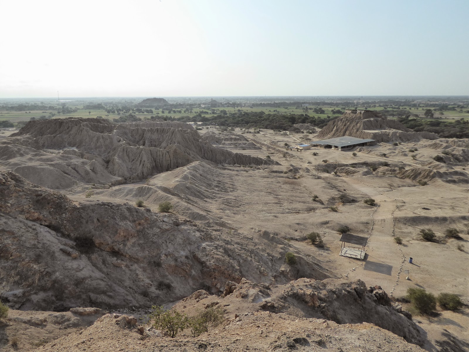
Also near Chiclayo, we visited another site called Túcume. This huge complex of pyramids, now crumbling and covered in mud and sand so they just look like giant mounds scattered across the landscape, was originally built by a different culture - the Sican people (approx CE 800-1350). It continued being used as an important regional centre by the Chimu and later the Incas. At the centre of the site is a hill known as Purgatory Hill, which we climbed to get a great view of the sheer scale of the area.  Purgatory Hill has a story behind its name. At the start of the Spanish occupation of this area, the Spanish lit fires atop this hill and claimed it was purgatory. In an attempt to scare the locals into converting to Catholicism they even dressed as devils and threw non-believing locals to their deaths.

Part of the Sechín site at Casma
We headed down from Chiclayo to Lima via the small town of Casma in order to visit yet another amazing set of ruins (Peru is full of them!) In this case, it was the ancient site of Sechín, dating from around BCE 1600. Most of it is a heap of rubble, but the main temple building has been restored to some extent, and the most interesting feature is the incredible bas relief carvings that decorate all the stone blocks of the building's outer wall. These original carvings represent all sorts of gruesome scenes of war and human sacrifice, including people being beheaded and eviscerated. Little is known about the Sechín people but it doesn't sound like they were the nicest of folks!

Gruesome bas relief carvings at Sechín - note beheaded heads!
We've spent the last couple of days in Lima. Today we went to see the San Francisco Monastery, which has a library dating back to the 16th century. I was in my element and wished I could have opened some of the thousands of ancient books there (sadly you are only allowed to gawp at them from a distance!) Our guide told us some of the larger books have pages of animal skin and covers of wood, and weigh over 20 kg. Wow!

Strange carving of two heads on top of one another, at Sechín
Tomorrow we're leaving to Peru and flying down to Santiago and then onto Patagonia, where with Kev's leg now 100% we will finally be hitting the Torres del Paine National Park that we missed on our previous visit. Can't wait!

Saturday, 26 September 2015

The Oldest Civilisation in the Americas

We've spent the last few days getting to know a bit more of Peru's history, from the oldest civilisation in the Americas to the turbulent recent past.

Ayacucho
From Ica, we set off for the less-visited city of Ayacucho, back up in the mountains. Ayacucho was the main base for the Sendero Luminoso (Shining Path) communist organisation. Starting in the early 80s, it waged a guerilla war against the military government that, predictably, responded with violence. This left much of the populace caught between the two sides with thousands of casualties, the majority poor people from the countryside. Sendero Luminoso declined in activity from 1992 when its leader was captured, but there are still sporadic bursts of activity.

The remains of the powerful Wari empire
We used Ayacucho as a base to visit the ruins of the Wari civilisation's capital city. This was a city of an estimated 50,000 people and was the centre of a pre-Inca empire extending over much of Peru between the years 500 and 900. There isn't much left of it today; although there are some remaining buildings and walls still standing, it's hard to imagine a city that big in the abandoned cactus-covered desert.

The main square in Lima
After Ayacucho, we took another night bus back down to the coast for a brief stay in Lima. We're planning to return here in about a month, so we just visited the main sites - the park filled with stray cats in Miraflores (which Jo loved), and a walk around the historic colonial-era centre. It felt a bit depressing as Lima is famous for being covered in white mist for half of the year. We cheered ourselves up by finding one of the first places in which pisco sours were made.

5,000 year old pyramids at Caral
We left Lima to travel further north along the coast to Barranca, the closest town to the ancient ruins of Caral. This is an astounding site - it dates from 5,000 years ago so is one of the cradles of civilisation. It's the oldest such site in the Americas, and was founded at the same time as the Egyptian pyramids were being built. There are remains of pyramids and residential buildings centred around a large square that are in amazing condition considering their age.

Being gluttons for punishment, we've now returned to the mountains, where we're hoping to do some more trekking from Huaraz.

Sunday, 30 August 2015

Cusco - Historic Inca Capital (And Tourist Capital Of South America)

We took a nightbus from Arequipa to Cusco, where we've spent the last five days. Although best known as the tourist hub for the thousands of visitors that flock to Machu Picchu each year, it is also a fascinating place in its own right, with some amazing Inca sites to check out in the city and surrounding area.

Inca walls in Cusco
Cusco was the capital of the Inca empire, founded in the 13th century. It's now a world heritage site and is an interesting mix of Incan and colonial architecture. Inca walls built with huge blocks of stone line many of the streets; the blocks, despite being all shapes and sizes (one is 12 sided!), fit together like a jigsaw so well that you cannot see any sign of mortar holding them together. Alongside the Inca features, you see plenty of evidence of the Spanish conquest - the main square with its Catholic cathedral and Jesuit church, for example. Despite being full of tourists, it's a beautiful city and we've enjoyed exploring it.

The cathedral in Cusco's main square
On our second day here, we met up with our German friends from the Colca Canyon and took a bus out to Tambomachay, one of four Inca sites within a few km of the city. We walked back, taking in all the other sites and managing to avoid tour groups in the main. The largest of these sites is Sachsaywaman ('sexy woman' is the best way to remember the name!), which was an enormous fortress guarding Cusco. Some of the stone blocks here were simply gigantic - the largest weighed around 300 tons. It's hard to imagine how such might could have fallen to a Spanish force of around 50 horsemen.  

The Inca ruins of Sachsaywaman
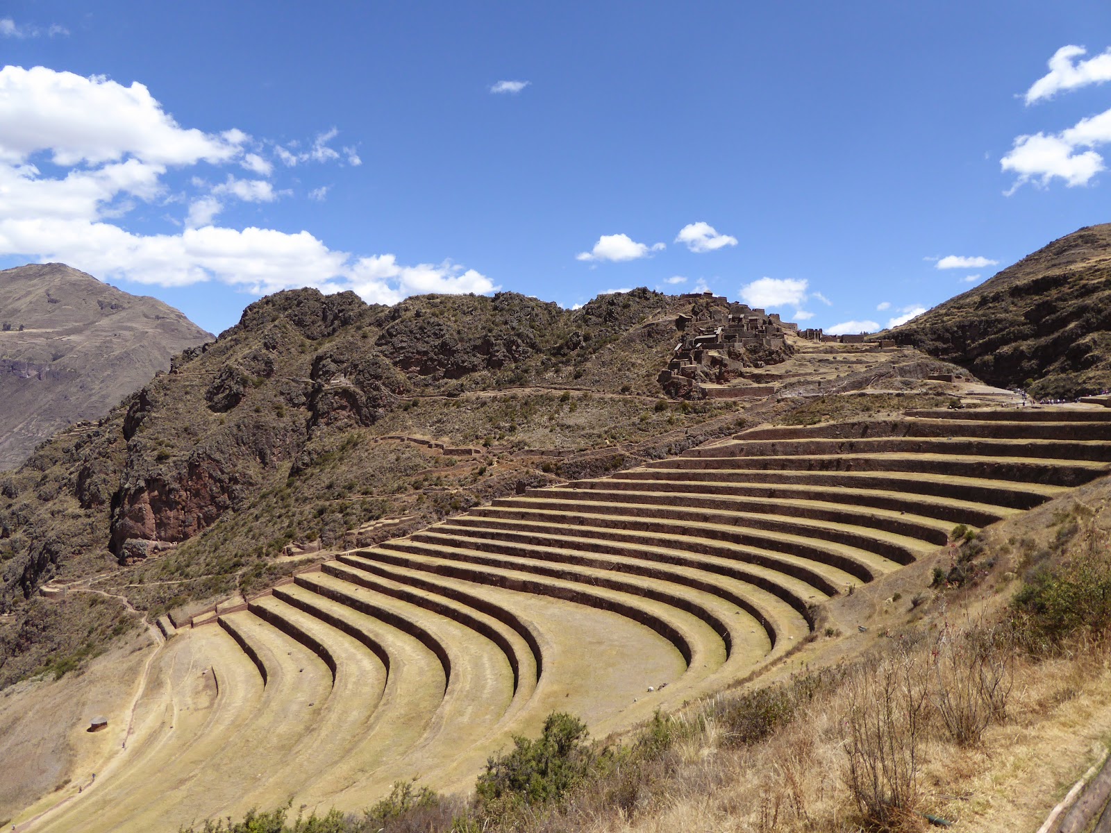
Other Incan ruins around Cusco include those at Pisac, an insanely touristy town nearby. We took a taxi up to the ruins from the town centre and were dismayed to find at least twenty tour buses outside, while inside were umbrella carrying tour guides and megaphones galore. Fortunately most groups seemed to be on their way out, so within an hour or so we had the place almost to ourselves. The site is a citadel and small town, with impressive agricultural terraces carved out of the steep hillside right down into the valley.

Inca terraces at Pisac
We saw more agricultural terraces at Moray, another Inca site nearby. The terraces here are unusual in that they are deep and circular - very striking. Research has shown a temperature variation of 15°C or more between the top and bottom, and it seems that the Incas used the area as a kind of laboratory to test the effects of different microclimates on crops.

Circular agricultural terraces at Moray
Perhaps my favourite of all the sites we visited here was the salt pans or Salinas near the village of Maras. This is a set of several hundred rectangular ponds on several levels, into which salt water flows from a subterranean source and evaporates to form salt. The view from above is quite stunning - a patchwork of rectangles, punctuated by local people harvesting the salt in buckets and bags. The pans vary in colour depending on how long they've been evaporating, from brown to sparkling white. You can walk across the whitest ones, which reminded us of the salt flats in Bolivia.

The Salinas (salt pans) near Maras
While in Cusco we've met up with several friends from the last couple of weeks in Peru. It's been lovely catching up over craft beer and pisco sours. Most of these have already visited Machu Picchu, but we have decided not to rush things... Instead we have booked ourselves on an epic 9 day trek to get there! We leave tomorrow and trek first to Choquequirao, another Inca city, before heading onto Machu Picchu. We look forward to telling you all about it in ten days time...