Showing posts with label salt flats. Show all posts

Thursday, 5 May 2016

Mountains Through a Kaleidoscope

Exploring the northwest of Argentina feels a lot different to the rest of the country. It has a much larger indigenous population, and the sounds, tastes and buildings could belong to any of the other nearby countries - the north of Chile, or the south of Perú or Bolivia. The main cities are Salta and San Salvador de Jujuy (or just Jujuy), but there is a string of small towns following the long Quebrada de Humahuaca ravine north towards the Chilean and Bolivian borders.

The Quebrada de Humahuaca, from Tilcara
We arrived in Salta from Corrientes with the intention of hiring a car to explore the region before heading south. Originally, our plan was to drive all the way 1000+km south to Mendoza, but the fee for leaving the car there made it prohibitively expensive. Also, I didn't fancy driving the whole way - Jo wasn't able to take the wheel as her licence was stolen in Perú. Instead, we decided to just take the car around the surrounding area and leave it in Cafayate, just 200km away.

The road up to the Hornical
Salta had the feel of a lot of the other Andean cities that we've liked along the way, like Arequipa in Perú or Sucre in Bolivia. It even has a cable car to the top of the nearby hill, which seems to be a trend in many South American cities (La Paz, Quito, Medellín, Rio de Janeiro, etc). Our highlight, though, was the High Mountain Archaeological Museum (or MAAM - the Spanish acronym). It contains the remains of two children sacrificed by the Inca to their mountain gods. They were buried at the top of the region's highest mountain, at 6739m, and their bodies and the intricate grave goods have been perfectly preserved in the freezing temperatures.

Salta's take on the ubiquitous cable car
We left Salta in our hire car, driving north along the Quebrada de Humahuaca on the RN9. We soon found that, although the main road was in good condition, almost anything off the side of it was less so. Trying to get to the Lagunas de Yala, we had to turn round along one dirt road as it had been completely covered by a landslide. We did make it there a different way, making slow progress along another dirt road as we tried to protect our car from any flying pebbles. It was worth it for the great views along the valley from the winding mountain roads, even if the lagunas weren't that spectacular.

Not this way, then
The real reason for visiting this area is to see the celebrated coloured mountains. The most famous of these is the Hill of the Seven Colours rising above the small town of Purmamarca. The hill certainly lives up to its name! As this is probably the most accessible of the coloured mountains, it is also the most visited. Many of the towns in this area have been overrun by stalls of llama wool knitted into every form imaginable. This didn't prevent us from enjoying the spectacular hill and the drive past the town (and more coloured valley walls) up to the Argentinian salt flats, the Salinas Grandes.

Only Seven colours?
The salt flats, although not as big or as well known as those at Uyuni in Bolivia, are still an impressive sight. They stretch miles into the distance, with no point of reference until the mountains on the horizon. This was where we first discovered that cars don't run so well at 4000m above sea level, needing a lot more effort to get up the hills! 

Walking across the Salina Grande
The next time we went this high was to yet another coloured mountain, called the Hornocal, following a tip from an English couple to whom we got chatting in a restaurant in Tilcara. After a long hour drive along another gravel track outside of the town of Humahuaca, the view suddenly appeared before us of one of the most jaw-dropping sights of our trip so far. The entire opposite side of the valley was like a giant kaleidoscope. The Hornocal is also called the Hill of the Fourteen Colours, rather trumping the Seven in Purmamarca! It was relatively quiet and doesn't appear in so many guidebooks as the other hill, maybe because of the more difficult location.

The Hornocal
We had based ourselves in the small town of Tilcara, which is perfectly positioned to drive to many of the sights in the region. It is also home to a Pucará - a pre-Inca fort - looking over the Quebrada. Unfortunately, it was misguidedly reconstructed in the 1950s and isn't viewed as particularly authentic. However, because of its strategic position, it does have fantastic views over the entire valley. The whole Quebrada de Humahuaca has been listed by UNESCO, not so much for its natural beauty, but because of its archaeological sites. It has been in continuous use for over 10,000 years as an important route down from the Andean highlands to the lowlands of the south of the continent.

The reconstructed Pucará de Tilcara
After finishing driving around the dry, desert-like Quebrada, we are now moving across to the more humid, jungle-like Calilegua National Park. We will then be heading south towards the wine growing regions of Cafayate and Mendoza.

A closer view of the Hornical

Sunday, 30 August 2015

Cusco - Historic Inca Capital (And Tourist Capital Of South America)

We took a nightbus from Arequipa to Cusco, where we've spent the last five days. Although best known as the tourist hub for the thousands of visitors that flock to Machu Picchu each year, it is also a fascinating place in its own right, with some amazing Inca sites to check out in the city and surrounding area.

Inca walls in Cusco
Cusco was the capital of the Inca empire, founded in the 13th century. It's now a world heritage site and is an interesting mix of Incan and colonial architecture. Inca walls built with huge blocks of stone line many of the streets; the blocks, despite being all shapes and sizes (one is 12 sided!), fit together like a jigsaw so well that you cannot see any sign of mortar holding them together. Alongside the Inca features, you see plenty of evidence of the Spanish conquest - the main square with its Catholic cathedral and Jesuit church, for example. Despite being full of tourists, it's a beautiful city and we've enjoyed exploring it.

The cathedral in Cusco's main square
On our second day here, we met up with our German friends from the Colca Canyon and took a bus out to Tambomachay, one of four Inca sites within a few km of the city. We walked back, taking in all the other sites and managing to avoid tour groups in the main. The largest of these sites is Sachsaywaman ('sexy woman' is the best way to remember the name!), which was an enormous fortress guarding Cusco. Some of the stone blocks here were simply gigantic - the largest weighed around 300 tons. It's hard to imagine how such might could have fallen to a Spanish force of around 50 horsemen.  

The Inca ruins of Sachsaywaman
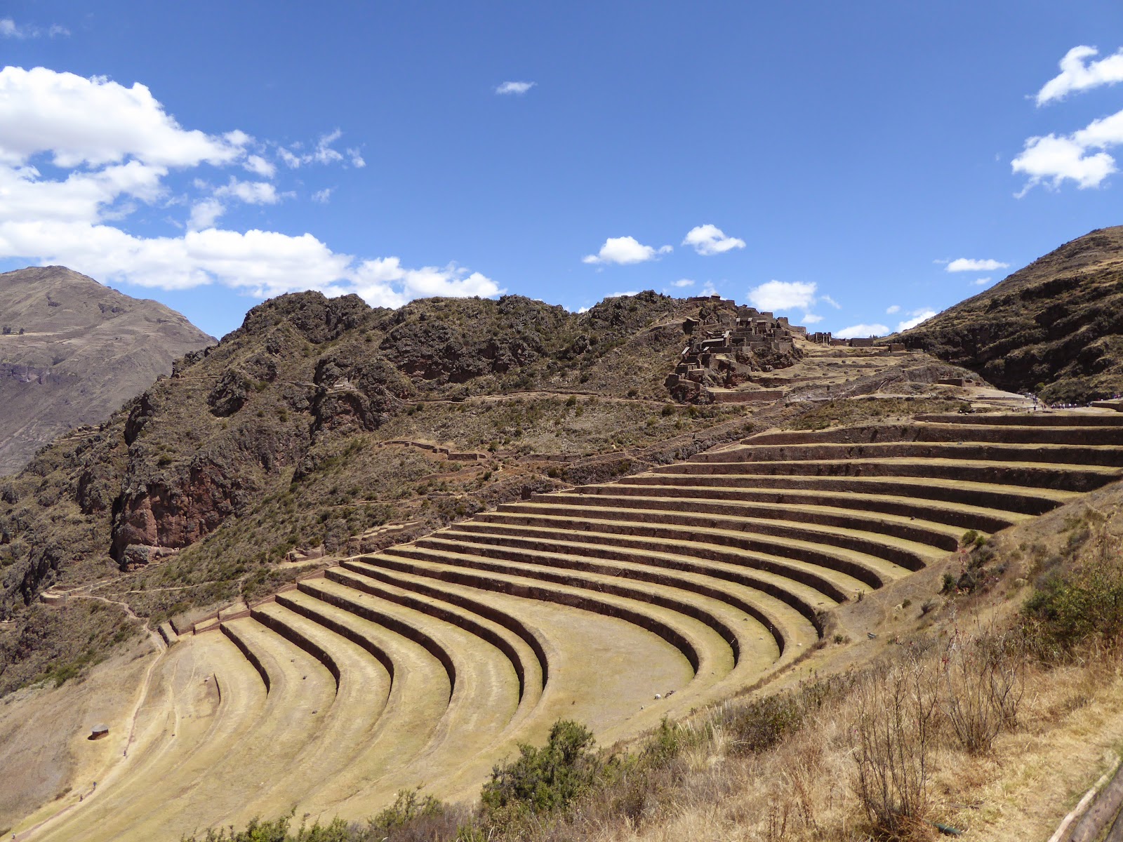
Other Incan ruins around Cusco include those at Pisac, an insanely touristy town nearby. We took a taxi up to the ruins from the town centre and were dismayed to find at least twenty tour buses outside, while inside were umbrella carrying tour guides and megaphones galore. Fortunately most groups seemed to be on their way out, so within an hour or so we had the place almost to ourselves. The site is a citadel and small town, with impressive agricultural terraces carved out of the steep hillside right down into the valley.

Inca terraces at Pisac
We saw more agricultural terraces at Moray, another Inca site nearby. The terraces here are unusual in that they are deep and circular - very striking. Research has shown a temperature variation of 15°C or more between the top and bottom, and it seems that the Incas used the area as a kind of laboratory to test the effects of different microclimates on crops.

Circular agricultural terraces at Moray
Perhaps my favourite of all the sites we visited here was the salt pans or Salinas near the village of Maras. This is a set of several hundred rectangular ponds on several levels, into which salt water flows from a subterranean source and evaporates to form salt. The view from above is quite stunning - a patchwork of rectangles, punctuated by local people harvesting the salt in buckets and bags. The pans vary in colour depending on how long they've been evaporating, from brown to sparkling white. You can walk across the whitest ones, which reminded us of the salt flats in Bolivia.

The Salinas (salt pans) near Maras
While in Cusco we've met up with several friends from the last couple of weeks in Peru. It's been lovely catching up over craft beer and pisco sours. Most of these have already visited Machu Picchu, but we have decided not to rush things... Instead we have booked ourselves on an epic 9 day trek to get there! We leave tomorrow and trek first to Choquequirao, another Inca city, before heading onto Machu Picchu. We look forward to telling you all about it in ten days time...

Monday, 29 June 2015

Leaving Chile for the Salt Flats of Bolivia

After re-arriving in San Pedro de Atacama, we booked a tour to take us into Bolivia, taking in scenery from deserts and lakes to the famous salt flats. We'd spent almost 3 months in Chile, so it was exciting to be moving on to a new, and very different country.

You can just see Jo in the background exploring the Quebrada del Diablo by bike
We had a day to fill in San Pedro, a place that we hadn't particularly enjoyed before. This time, instead of going on any crowded and hectic tours, we hired bikes for a day to explore a bit more independently and visit the nearby Quebrada del Diablo (Devil's Canyon). In appearance, it is very similar to the Valle de la Muerte, with red, Mars-like rocks. The huge draw was that we were almost the only people there to admire the otherworldly landscape.

The border crossing into Bolivia
The first thing we noticed on crossing into Bolivia is the difference in language. Chilenos speak Spanish very quickly with their own unique dialect and it can be very difficult to understand at times. Bolivians, however, speak a lot more slowly and we already feel more confident about our language skills.

The fantastic group for the salt flat tour
Our three day tour of the southern altiplano was fantastic. We had a great group of people in our jeep, with the two of us, our Swiss friends and another English couple. Plus our Bolivian driver, Pedro, who was good fun as well as knowledgeable about everywhere we went. Each day brought new, spectacular scenery and Pedro did a good job of avoiding the other tour groups. We were lucky that we'd spent the last couple of weeks at altitude, as the whole tour took place at over 3000m. Some others weren't so lucky and definitely didn't have a good time.

Us in front of the Laguna Colorada
The first day took in a number of coloured lakes, geysers and mud pools and windswept rock formations, all set in barren but colourful desert. We stayed that night in a hostel next to Laguna Colorada - coloured red from the brine shrimp in it that give flamingoes their distinctive colour. There was no heating in the hostel and the temperature dropped below -10°C, which made for a chilly night.

Strange rock formations in the Valle de las Rocas
On the next day we visited more lakes surrounded by snow-capped mountains, with their shores grazed by vicuñas. There were more impressive rock formations, created by volcanic lava that had been eroded into strange shapes by the wind over the millennia. We finished the day by crossing a small salt flat, then stayed in a hotel constructed from salt on the edge of the Uyuni salt flat - the largest in the world.

Sunrise over the salt flat from Isla Incahuasi
The final day of the tour was spent crossing the Uyuni salt flat. First stop was sunrise at the 'island' Isla Incahuasi, a salt island rising out of the flat. The drive was a strange experience, moving along in the dark with no landmarks - it felt like being in an aeroplane when the headlights were turned off. The lack of any landmarks allowed us to have fun later in the morning taking the classic perspective-altering photos. We finished the day, and the tour, in Uyuni at the train cemetery. I felt this was similar to Humberstone and Santa Laura, with trains that used to carry the mined salt around left to rust in the desert.

Blown away by the salt flats
Now we are in Bolivia, it is time to explore a new country. We're heading off tomorrow north from here towards Potosí, the highest city in the world.

Sunday, 14 June 2015

Touring the Atacama Desert

We were in for a shock arriving in San Pedro de Atacama after our 16 hour night bus. For the majority of our time in Chile, we've been in low season. That was still the case in San Pedro, but the only people in the town are tourists and people selling things to tourists. It's in the middle of the Atacama Desert - the highest (San Pedro is 2,400m above sea level) and driest (some weather stations have never received rain) desert in the world. This makes it an uncomfortable place to be. The temperature fluctuates between scorching hot in the sun, to chilly in the shade, to below 0°C at night. Not great when none of the hostels have heating in the rooms. The extreme aridity painfully dries out your nose, throat and skin.

The tourist-heavy main drag in San Pedro
The main attraction is the surrounding scenery - volcanoes, salt flats, lakes, valleys and the night sky. Despite having learnt the lesson that tours are bad many times before, we decided to go with a tour company in order to see as much as possible. Although the tours were good, we're left feeling a bit flat - there's no effort, and therefore less reward, in being taken to see spectacular scenery in a convoy of minibuses with 10-100 other people. That said, the scenery is spectacular.

The valleys of Valle de la Muerte and Valle de la Luna, both near to the town, have completely different characters. Valle de la Muerte consists of red rocks and dusts in strange formations. Because of the colour, it was originally called the Valley of Mars, Valle del Marte in Spanish. This was mistranslated to Valle de la Muerte, or Valley of Death, and the name stuck. Valle de la Luna, Valley of the Moon, similarly appears like the moon. Much of the rock is formed from salt crystals and gives the valley an otherworldly moon-like appearance.

The Valle de la Muerte The 3 Marias rock formation in the Valle de la Luna

The Tatio geyser field

Another of the big draws around here is the Tatio Geysers, the highest geyser field in the world at 4,320m. This is now Jo's new highest place record. We set off before dawn to be there for sunrise, and to 'enjoy' breakfast at -10°C. The geysers were stunning against a backdrop of even higher mountains in the early morning light. We also visited some nearby hot springs to relax later that afternoon, although stepping out of the warm water into the frigid shade was painful.


Our final tour was to see the Miscanti and Miñiques altiplano lakes at 4,220m above sea level. These were again beautiful set against the 6,000m volcanoes behind them. We continued on to the Atacama salt flat, surrounded by mountains reflected in the shallow pools of water. This made for perfect photographs of flamingoes ignoring the flocks of tourists.

Flamingoes in the Atacama salt plain

Us, the Milky Way, and the Southern Cross
The highlight of our stay was a stargazing trip. The Atacama desert has perfect conditions to view the stars - it is so high and dry that there is little atmospheric interference. As well as being able to see the Milky Way and other galaxies (the Magellanic clouds) with the naked eye, there were several telescopes set up for us. We were taken around various amazing views - Saturn, star forming nebula, binary stars and other galaxies amongst them.


We've met up with a Swiss couple that we'd met in Pucón, and we're now hoping to travel with them for a bit around the remaining parts of northern Chile, starting in Iquique.