Showing posts with label language. Show all posts

Tuesday, 15 March 2016

Curaçao Drinking in Curaçao

In order to skip the dangerous Venezuela, we found the cheapest flight to Guyana would go via the Dutch island of Curaçao. We decided to spend a few days there to do a few dives and drink the famous liqueur. We also discovered that the main town, Willemstad, is a UNESCO world heritage site!

We didn't get any diving photos, so here's one of a beach instead
The dives here were great - we were collected by the guys that run Scubaçao (unfortunately not pronounced Scuba-Cow) and driven around to the dive sites. It made a nice change to be able to just walk off the beach and dive straight away without having to take a boat. The visibility was amazing, around 30m, and there was plenty of healthy coral, lots of different fish and even some turtles. The best site was probably the one called 'Tugboat' - named after a tug that sunk there when a ship dropped an anchor on it. It is now home to several schools of fish and was fascinating to swim around.

The colourful waterfront in Willemstad
When we weren't diving, we walked around the old city, which was founded in 1634. It spent much of its life as a slave trading port, and there are a couple of good museums dedicated to that awful subject today. The slave trade, the proximity to Spanish-speaking Venezuela, its status as part of the Netherlands and today's tourism has led to an interesting mix of cultures. The local language, Papiamentu, is a combination of Portuguese, Spanish, Dutch and English and we found it strange to be able to pick up words of it here and there.

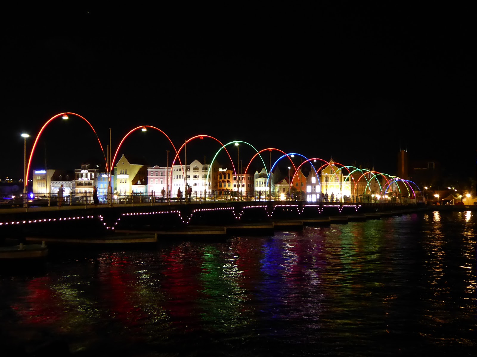
The Queen Emma floating bridge across Willemstad harbour
Willemstad is now home to a unique floating bridge across the harbour entrance, which swings open when a ship needs to pass. Often, those ships are cruise ships, and the island is full of people supping cocktails made from the local blue curaçao liqueur. From our experience, it's used to make rather sickly blue-green cocktails that pack quite a punch.

Cocktails!
We're now recovering from our hangovers and flying back to the mainland, to Guyana.

Saturday, 25 July 2015

To Tour or Not to Tour in Eastern Bolivia

When Kev last wrote, we were just about to leave Sucre for Santa Cruz in eastern Bolivia. Santa Cruz is a big, very busy city down at an altitude of only 400m or so - quite a change from our last few weeks high in the altiplano. The weather was noticeably more humid and the city was partly flooded when we arrived, after heavy rains over the last two weeks. I think we will always associate Santa Cruz with grey skies!  There is very little to do in the city itself but we wanted to use it as a base for several activities in the area, beginning this week with the Jesuit Missions Circuit.

The cathedral in Santa Cruz - the Pope visited here a week before we arrived
There are a number of villages within a day's travel of Santa Cruz, all founded by Jesuit missionaries in the late 17th and early 18th centuries, and all with unusual, very beautiful Jesuit churches. Six of these were collectively designated a Unesco World Heritage Site in the 1990s and the route round them is known as the Jesuit Missions Circuit. Tour agencies offer a 3 or 4 day tour for around 450 US dollars. To tour or not to tour? It didn't take us long to choose to go it alone.  But now we had to negotiate the local transport, which is notoriously slow and unreliable in this region (hence why most travellers opt for the tour!).

The viewpoint in Santiago de Chiquitos
While the tiny village of Santiago de Chiquitos, is not officially part of the missions circuit, we had been recommended to make a stop here to enjoy the natural beauty of the surrounding area. We stayed in Santiago's only hostel, which also serves as a restaurant as well as an art exhibition centre. The hostel had a lovely garden with toucans frequenting one of the fruit trees. We climbed up to the viewpoint just out of town and were rewarded with glorious views of the Tucabaca Valley below - a sea of trees. During this walk we saw one of the largest butterflies I've ever seen; those who know me well can imagine my reaction. We also hired a local guide who took us though the jungle to visit two amazing caves, one with rock paintings and one with a lovely waterfall.

The church in San José de Chiquitos
From Santiago we moved on by bus to San José de Chiquitos, arriving in the late afternoon in time to see the church. Unlike those later on the circuit, this church was the only one to be built of stone. It was huge, with four main buildings stretching along one whole side of the village square. The cloister-like corridors around a central garden had walls adorned with paintings in the characteristic Jesuit style. We stayed in a very basic hotel and were up at dawn to catch the only bus of the day to San Ignacio de Velasco, our next stop.

The church at San Miguel - all of the others, apart from San José, are in a similar style
The local bus to San Ignacio was interesting - 6 hours bumping along the red, dusty, unpaved road, stopping to pick up more and more people and more and more cargo, including several crates of (live) chickens. From San Ignacio we spent a day with a driver taking us round the three other Jesuit villages nearby - Santa Ana, San Rafael and San Miguel. All of these churches were lovely, and very representative of the Jesuit style: carved wooden columns; adobe walls painted white on the inside and then decorated with simple floral motifs, mostly in reds and oranges; ceilings of reeds or bamboo; wonderfully carved wooden pulpits decorated in gold; and magnificent altars covered in gold, silver or mica. Perhaps my favourite was San Rafael, where the interior paintings also included angels playing various instruments.

Inside the churches at San Rafael and San Miguel
The next leg of the trip, up to Concepción, was to be the most challenging. There was only one bus a day from San Ignacio and we duly got on it at 11 am. At 12.30, the bus broke down, literally in the middle of nowhere. There were no other buses due until the evening, so we were all given (some of) our money back and then left to wait hopefully on the side of the road in the heat and the dust. An hour later, Kev and I ended up getting a lift with a few other people in a huge lorry, with him in the back while I was squashed into the cab. The truck dropped us at the nearest village, 25 km away, and after a lot of waiting around and negotiating with a bus company office, we finally procured ourselves a minibus to Concepcion, where we arrived around 6 pm. Only 3 hours later than planned, and ironically, this all worked out cheaper than the original bus!

Waiting for a lorry to come along
We were able to look at the church in Concepción in the evening before mass, and the atmospheric lighting at this time almost made the long journey to arrive this late worth it. The next day we had a smooth journey to nearby San Javier, the last of the circuit, and back to Santa Cruz.

Made it! The final church in San Javier
The whole experience was a challenging one, but certainly far more rewarding and eye-opening than a tour would have been. We saw no other tourists on the buses, but got to travel as the locals have to and experience the difficulties of living so remotely with so little transport. We had time to see all the churches for ourselves, as well as seeing the rest of the villages, eating in local restaurants and speaking only in Spanish. We even worked out that we saved a third on what the tour would have cost, despite spending more than twice as much as time. Once again we've learnt that the easy option isn't always the best one.

Wednesday, 15 July 2015

Surviving the Bus After Trekking the Cordillera de los Frailes

We spent a long time (for us) in Sucre - a whole week, which was dedicated to brushing up our Spanish skills. We each had a private teacher (which is affordable in Bolivia), and feel that we made a lot of progress. We certainly feel more confident conversing with people now.

Sucre - our home for the last week or so
The real highlight of our visit to Sucre, though, was a 4-day trek in the nearby Cordillera de los Frailes. We organised it through a local agency, and spent three full days walking before returning by local bus on the final morning. We were joined by a friendly English couple, Steve and Harriet, and the fantastic local guide, Zulma, to make 5.

The Cordillera de los Frailes
Each day of the trek showed us something different: the first day took us to 2000 year old cave paintings; the second day to a huge, ancient volcanic crater with a village in the middle; and the third to 65 million year old dinosaur footprints. The best thing about it, though, was to spend all of that time walking amid stunning landscapes. Each new turn in the road, collapsing bridge over a river or vertiginous path alongside a waterfall brought new hues in the mountains shaped by millennia of different layers of rock.

Coloured rock lining the way
The final day took us back to Sucre in only two and a half terrifying hours. Having walked around the cordillera, we now needed to cross back over the mountains. The rickety local bus struggled along the barely wide enough unmade roads, with a cliff on one side and a sheer drop on the other side. Occasionally there were trees bordering it, which may have broken the fall if the bus driver made a mistake. Luckily, he didn't, and we have survived to tell the tale before flying to Santa Cruz tomorrow.

Hiking in the cordillera

Monday, 29 June 2015

Leaving Chile for the Salt Flats of Bolivia

After re-arriving in San Pedro de Atacama, we booked a tour to take us into Bolivia, taking in scenery from deserts and lakes to the famous salt flats. We'd spent almost 3 months in Chile, so it was exciting to be moving on to a new, and very different country.

You can just see Jo in the background exploring the Quebrada del Diablo by bike
We had a day to fill in San Pedro, a place that we hadn't particularly enjoyed before. This time, instead of going on any crowded and hectic tours, we hired bikes for a day to explore a bit more independently and visit the nearby Quebrada del Diablo (Devil's Canyon). In appearance, it is very similar to the Valle de la Muerte, with red, Mars-like rocks. The huge draw was that we were almost the only people there to admire the otherworldly landscape.

The border crossing into Bolivia
The first thing we noticed on crossing into Bolivia is the difference in language. Chilenos speak Spanish very quickly with their own unique dialect and it can be very difficult to understand at times. Bolivians, however, speak a lot more slowly and we already feel more confident about our language skills.

The fantastic group for the salt flat tour
Our three day tour of the southern altiplano was fantastic. We had a great group of people in our jeep, with the two of us, our Swiss friends and another English couple. Plus our Bolivian driver, Pedro, who was good fun as well as knowledgeable about everywhere we went. Each day brought new, spectacular scenery and Pedro did a good job of avoiding the other tour groups. We were lucky that we'd spent the last couple of weeks at altitude, as the whole tour took place at over 3000m. Some others weren't so lucky and definitely didn't have a good time.

Us in front of the Laguna Colorada
The first day took in a number of coloured lakes, geysers and mud pools and windswept rock formations, all set in barren but colourful desert. We stayed that night in a hostel next to Laguna Colorada - coloured red from the brine shrimp in it that give flamingoes their distinctive colour. There was no heating in the hostel and the temperature dropped below -10°C, which made for a chilly night.

Strange rock formations in the Valle de las Rocas
On the next day we visited more lakes surrounded by snow-capped mountains, with their shores grazed by vicuñas. There were more impressive rock formations, created by volcanic lava that had been eroded into strange shapes by the wind over the millennia. We finished the day by crossing a small salt flat, then stayed in a hotel constructed from salt on the edge of the Uyuni salt flat - the largest in the world.

Sunrise over the salt flat from Isla Incahuasi
The final day of the tour was spent crossing the Uyuni salt flat. First stop was sunrise at the 'island' Isla Incahuasi, a salt island rising out of the flat. The drive was a strange experience, moving along in the dark with no landmarks - it felt like being in an aeroplane when the headlights were turned off. The lack of any landmarks allowed us to have fun later in the morning taking the classic perspective-altering photos. We finished the day, and the tour, in Uyuni at the train cemetery. I felt this was similar to Humberstone and Santa Laura, with trains that used to carry the mined salt around left to rust in the desert.

Blown away by the salt flats
Now we are in Bolivia, it is time to explore a new country. We're heading off tomorrow north from here towards Potosí, the highest city in the world.

Sunday, 14 June 2015

Touring the Atacama Desert

We were in for a shock arriving in San Pedro de Atacama after our 16 hour night bus. For the majority of our time in Chile, we've been in low season. That was still the case in San Pedro, but the only people in the town are tourists and people selling things to tourists. It's in the middle of the Atacama Desert - the highest (San Pedro is 2,400m above sea level) and driest (some weather stations have never received rain) desert in the world. This makes it an uncomfortable place to be. The temperature fluctuates between scorching hot in the sun, to chilly in the shade, to below 0°C at night. Not great when none of the hostels have heating in the rooms. The extreme aridity painfully dries out your nose, throat and skin.

The tourist-heavy main drag in San Pedro
The main attraction is the surrounding scenery - volcanoes, salt flats, lakes, valleys and the night sky. Despite having learnt the lesson that tours are bad many times before, we decided to go with a tour company in order to see as much as possible. Although the tours were good, we're left feeling a bit flat - there's no effort, and therefore less reward, in being taken to see spectacular scenery in a convoy of minibuses with 10-100 other people. That said, the scenery is spectacular.

The valleys of Valle de la Muerte and Valle de la Luna, both near to the town, have completely different characters. Valle de la Muerte consists of red rocks and dusts in strange formations. Because of the colour, it was originally called the Valley of Mars, Valle del Marte in Spanish. This was mistranslated to Valle de la Muerte, or Valley of Death, and the name stuck. Valle de la Luna, Valley of the Moon, similarly appears like the moon. Much of the rock is formed from salt crystals and gives the valley an otherworldly moon-like appearance.

The Valle de la Muerte The 3 Marias rock formation in the Valle de la Luna

The Tatio geyser field

Another of the big draws around here is the Tatio Geysers, the highest geyser field in the world at 4,320m. This is now Jo's new highest place record. We set off before dawn to be there for sunrise, and to 'enjoy' breakfast at -10°C. The geysers were stunning against a backdrop of even higher mountains in the early morning light. We also visited some nearby hot springs to relax later that afternoon, although stepping out of the warm water into the frigid shade was painful.


Our final tour was to see the Miscanti and Miñiques altiplano lakes at 4,220m above sea level. These were again beautiful set against the 6,000m volcanoes behind them. We continued on to the Atacama salt flat, surrounded by mountains reflected in the shallow pools of water. This made for perfect photographs of flamingoes ignoring the flocks of tourists.

Flamingoes in the Atacama salt plain

Us, the Milky Way, and the Southern Cross
The highlight of our stay was a stargazing trip. The Atacama desert has perfect conditions to view the stars - it is so high and dry that there is little atmospheric interference. As well as being able to see the Milky Way and other galaxies (the Magellanic clouds) with the naked eye, there were several telescopes set up for us. We were taken around various amazing views - Saturn, star forming nebula, binary stars and other galaxies amongst them.


We've met up with a Swiss couple that we'd met in Pucón, and we're now hoping to travel with them for a bit around the remaining parts of northern Chile, starting in Iquique.

Saturday, 25 April 2015

Rural Chiloé and a Volcanic Eruption

Our original plan from Punta Arenas was to proceed back to Puerto Natales and then take a four day ferry up to Puerto Montt, significantly further north in Chile. However, the boat schedule turned out not to be in our favour and we were faced with the choice of a 32 hour bus journey or a two hour flight. It didn't take us too long to decide!

We were lucky to be able to get on a flight the very next morning and after landing in Puerto Montt headed straight to Ancud, in the north of the main island of Chiloé. Chiloé is an archipelago of islands off of the west coast of Chile, and was one of the last places remaining under Spanish rule before finally becoming part of independent Chile in 1826. It is famous for its fertile soil (and wet weather!), its folklore and its iconic wooden Jesuit churches.

The beach at Ancud, with the volcanoes of Osorno (left) and Calbuco (right, before it erupted) in the distance
We had a day exploring Ancud, which is a quiet town with a really beautiful seafront. The museum was all in Spanish but informative about Chiloé's history - plus it had a blue whale skeleton on display. We watched the sunset over the bay from Fort San Antonio, one of the last Spanish strongholds, looking over the sea with the mainland and surrounding islands in the distance.

Some of the sunken forest
We decided we'd like to see some more nature so spent a couple of days at a homestay in Chepu, a tiny settlement just north of the Chiloé national park. Chepu was very rural and a welcome change for us. It was really just a string of farms spread out along a couple of dirt roads, set in picturesque hilly scenery. We had a long walk one day to Playa Aulen beach on the west coast, where we watched huge waves rolling in from the Pacific Ocean. En route we saw a sunken forest. This surreal spectacle was created by the earthquake and tsunami here in 1960, which caused the ground to sink 2m.


The farmstay
The Chilote family we stayed with were incredibly friendly and welcoming; we felt like part of the family and were very well looked after. The home cooking was incredible - on the first day we were served a three course meal with fresh seafood soup, followed by roast ham (from the farm itself) with homegrown potatoes and tomatoes, and then creme caramel. The second night our portions of a meaty local fish, cooked beautifully with lemon and tomato, were so large that we could barely manage half each! We had the rest for lunch the next day. All this for incredibly cheap and we got a lot of practice with our Spanish as the family spoke no English.

The beach near Chepu The rolling hills around Chepu
During early evening on our first night at the homestay we went for a short walk and noticed a very dense looking cloud. Later on we discovered this was no normal cloud but the ash cloud from the eruption of Volcan Calbuco, near Puerto Montt. So far we have been lucky not to be affected by this but flights have been cancelled, nearby villages to the volcano have had to be evacuated as they are 50 cm deep in ash, and there is a strong chance the river might flood. We'll stay in Chiloé for now...

The volcanic cloud from Calbuco