Showing posts with label valleys. Show all posts

Thursday, 19 May 2016

The Fertile Valley in a Desert

We left Cafayate, having a vague plan of heading south towards Mendoza. We had a list of places we might want to stop at to break up the journey, but none sounded that appealing. Instead, we decided to try and make it all the way down to San Juan, just 2 hours north of Mendoza. Importantly, it's a decent base to make a trip to Ischigualasto Provincial Park, a UNESCO world heritage site.

The 'Submarine' - one of the famous rock formations in Ischigualasto
After our 5 hour bus journey from Cafayate to Tucumán, we bought our tickets for the next leg - 11 hours overnight to San Juan. Despite buying the tickets from a company called AndesMar with plenty of time to spare, we still nearly missed it. We stood at the terminal, staring at a lone FlechaBus, thinking that our bus had been delayed. Luckily, I went to find out if anybody knew where our bus was and was told that it was the one that had been sitting there all that time. We should probably have realised that the FlechaBus at the same time, going to the same place and at the same price was ours!

The 'Sphinx' in Ischigualasto
We'd heard about Argentinian buses serving wine with dinner, but hadn't experienced it until now, so had begun to think it was a bit of a myth. We can now confirm that this actually happens! We were served a meal as good if not better than in most restaurants here, with proper metal cutlery and drinks options including red and white wine. The journey was quite comfortable, with large seats that reclined almost horizontally.  But however comfortable a night bus is, we still find that they leave us needing to catch up on sleep the next day. We hadn't booked anywhere to stay and, after looking at a couple of abominable hostels, found a hotel to check in to. Annoyingly, they wouldn't match a price on our favoured hotel-booking website, so we used their wifi while in reception to make a reservation before checking in. This didn't seem the most sensible business decision, as they would now be paying 10%+ commission to the website.

A field of balls in Ischigualasto
San Juan didn't hold much of interest for us, so we soon set off to San Agustín de Valle Fértil. We'd hoped to hire a car, as we knew that it was impossible to get to Ischigualasto park with public transport. Unfortunately, we'd been in San Juan at a weekend and most businesses in Argentina don't open on a Saturday afternoon or Sunday. Luckily, the incredibly helpful owners of the place we were staying in San Agustín helped us to organise a reasonably priced taxi to take us there.

The lake in San Agustín
The park was worth the effort. The main sights are quite spread out, so the standard thing to do is to drive around in a convoy following a guide, then stop at several points to appreciate the landscape from closer up. The park is home to the oldest dinosaur fossils that we have yet discovered, from the Triassic Period around 250 million years ago. The desert-like landscape is sculpted by rain and wind, creating incredible shapes in the layered rocks. Palaeontologists don't need to dig here - they just wait for a rain shower and see what's been uncovered by the erosion.

Layers of rock, just waiting to be eroded to reveal the next dinosaur
After Ischigualasto, we were driven back to San Juan by our hosts, from where we took a bus down to Mendoza. We should be meeting our friends Ralph and Shehnaaz there to explore the famous wine growing region together.

Sunday, 25 October 2015

Trekking Torres del Paine: No Torres But (Big) Paine

Paine Grande, that is - the highest peak on the W-trek in the Torres del Paine National Park.

The Torres del Paine are in the cloud behind us
The renowned W-trek (named because its route looks like the letter W) takes in a stunning array of scenery - snowy mountains, valleys, turquoise lakes and several glaciers. At one end are the eponymous Torres del Paine granite spires and at the other is the Grey glacier and lake, both flanking the beautiful French Valley. We were unlucky not to see the Torres del Paine but had wonderful weather for the rest of the trek, including Paine Grande.

The entrance to the Valle Francés, with Paine Grande on the left and Los Cuernos on the right
There are several ways of doing this trek - ranging from expensive to very expensive. The cheapest would be to camp (although you still have to pay a large fee for many of the campsites), taking all of your own food, and the most expensive to stay in dormitories in refugios with all food provided. There are myriad variations on this - the refugios can provide tents, sleeping bags, etc. We decided on a happy medium - staying in the (warm!) refugios and having dinner there, but carrying our own breakfast and lunch. This meant that we didn't have to carry stoves or utensils for cooking, but it saved us some money on the extortionate food costs. Staying in refugios does limit your options a bit - you have to book in advance so you can't change your route (east-west or west-east), and the campsites are better located for the French Valley day.

Refugio Paine Grande and its namesake towering above it
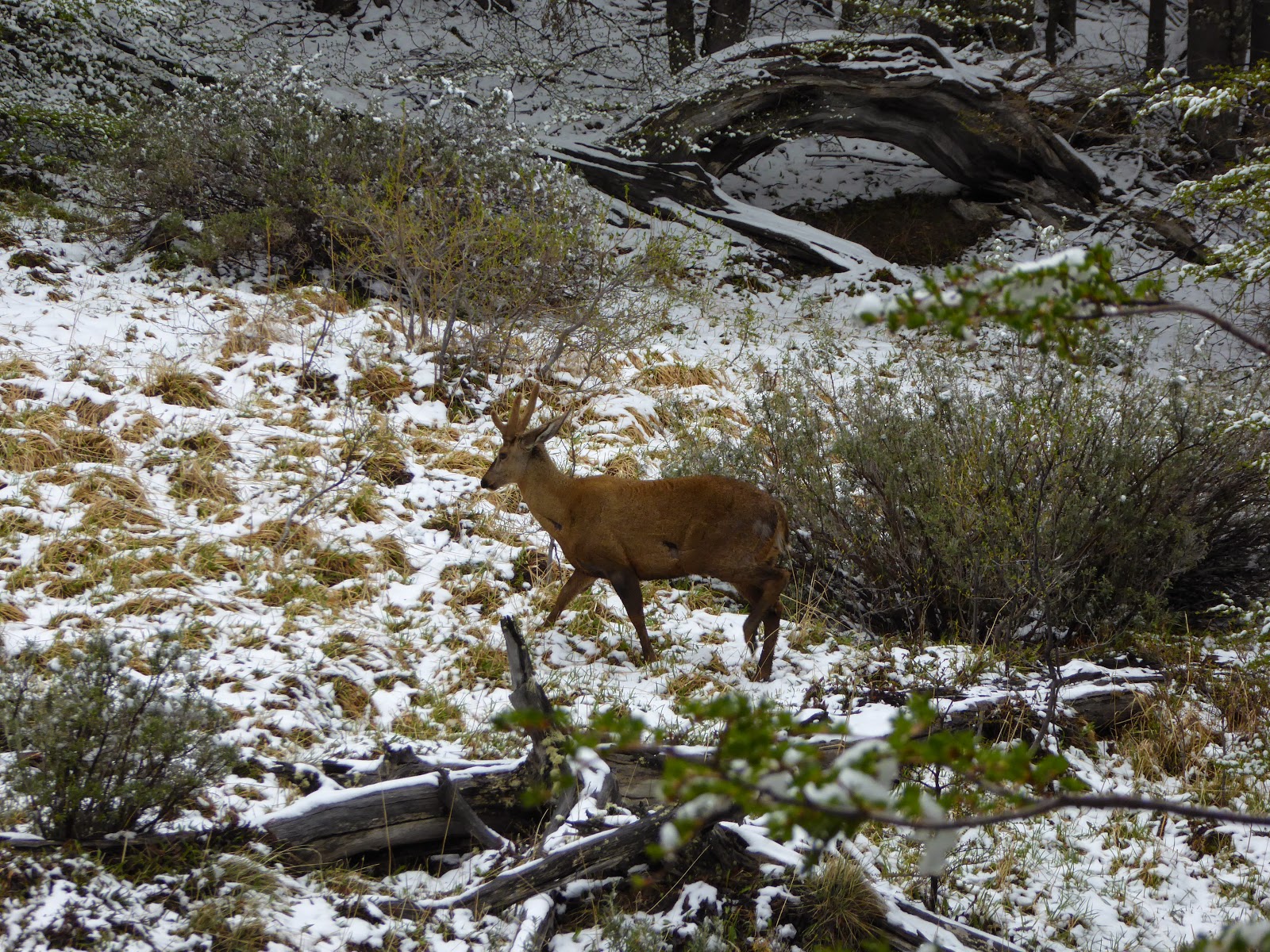
We took the (expensive) bus from Puerto Natales to the park entrance to pay the (expensive) entrance fee. The weather was pretty bad - grey and snowing lightly - and it was recommended to go west-east as there wasn't much chance of seeing the Torres in the east. Unfortunately, we'd booked our refugios to go the other way round, so we took an (expensive) shuttle bus to the start of the trail. We walked through the snow to the Refugio Chileno where we left our bags and continued up to the base of the Torres which, predictably, were hidden in the low cloud. The day was brightened by coming across two of the critically endangered (1500-2000 remaining) huemul deer, making a perfect Christmas card picture.

A huemul deer - there are only 20-100 in the national park
On the second morning we saw that the Torres were still covered in cloud, so we decided not to make the 4 hour round trip up to them again, and instead returned back down the valley towards Lake Nordenskjöld. We were able to enjoy the weather beginning to clear as we walked with the aquamarine lake to our left and the cordillera to our right. The colours had dramitcally changed from a black and white film yesterday to technicolour today. Our second refugio was at Los Cuernos (The Horns), named after the nearby distinctive grey granite peaks topped with a stripe of black rock. Our third day took us past the Cuernos into the French Valley. This was our favourite day of the trek - the steep valley passes the Glacier del Francés, where you can see avalanches of ice falling towards the valley floor, and continues to an amazing viewpoint surrounded by mountains and spires of rock. The return from the valley takes you back past these mountains and the glacier, back towards the bright blue lake.

At the top of the Valle Francés
After the valley, we continued through a section of skeletal remains of trees that were burnt in a forest fire in 2011-12. It was started by a hiker and burned around 176km² of the park. There are now strict rules about fire use - there are no fires or stoves allowed on the trails and you are only allowed to cook inside when at the refugios or campsites. Despite the lack of green trees, there are still fantastic views of the mountains reflected in the still lakes.

Los Cuernos reflected in Lake Sköttsberg
Our final two days took us from the Refugio Paine Grande up to Refugio Grey and back again. This walk takes you along the banks of Grey Lake, with icebergs floating in it which have fallen from Grey Glacier. It was a fitting end to the trek to emerge from the forest and see the glacier stretching across the lake in front of you.

Glacier Grey
On the final day, we took the (expensive) catamaran back across the lake to the starting point for our (expensive) bus back to Puerto Natales to relax for a couple of days. We are now returning to Argentina to meet Jo's family for a couple of weeks of trekking around El Calafate and El Chaltén.

Leaving the park, we finally got to see the Torres!
The granite spires in the centre of the photo.

Wednesday, 9 September 2015

Trekking to Machu Picchu

A few weeks ago, after hearing about the less-visited Inca ruins at Choquequirao, I looked at my map and saw a very wiggly, mountainous trail that continued on towards Machu Picchu. I remember saying 'that looks ridiculous'. We've just returned from hiking that trail, and the 8 days it took have been some of the hardest, and most rewarding, trekking of our lives. There was very little walking on the flat, and relentlessly steep descents and ascents into and out of canyons:


Day 1: down 800m;
Day 2: down 700m; up 1500m;
Day 3: explore Choquequirao ruins; up 300m; down 500m;
Day 4: down 700m; up 1100m;
Day 5: up 1300m to 4150m San Juan pass; down 700m;
Day 6: up 1100m to 4660m Yanama pass; down 1800m;
Day 7: down 700m;
Day 8: up 500m; down 500m;


The main square at Choquequirao
We'd chosen this trek to avoid the crowds on the other trails in the area and we weren't disappointed. On the first couple of days we saw just a handful of people making their way to, and from, the Choquequirao ruins. We felt privileged to have this remote hilltop city to explore almost to ourselves. This site is also host to the unique 'Llama Terraces' - white stone depictions of llamas making their way up the dizzyingly steep hillside. We were also lucky enough to spot a condor soaring past.

Llamas climbing up their steep terrace
Nobody else continued on past Choquequirao as we did though - we didn't see any other hikers until day 7. This part of the trek contained some of the hardest days - clambering up to passes above 4000m in both sun and snow. The views (when it was sunny) were incredible - of adjoining canyons bordered by mountains topped with glaciers. On one day we also had the unforgettable experience of camping on Inca terraces, looking down to a foaming river far below.

Camping on Inca terraces
On the 7th day we joined the more popular Salkantay trek and were dismayed at the large groups going the same way as us. We managed to find more solitude on the final day, however, when we left at 4:30am to climb to some more Inca ruins at Llactapata. This gave us our first view of Machu Picchu, on the neighbouring peak, although it still seemed a long way away. From there, we made our final descent of the trek, where we had lunch while waiting for a train to take us the short distance to Aguas Calientes - the (tourist trap) entrance town to Machu Picchu.

Our group at the end of the tough, snowy, ascent to the Yanama Pass
During our trek, we were accompanied by a mule train that carried tents, food, cooking equipment and spare clothes for us. It was hard enough with this assistance; it would have been absolute torture to have attempted it without. We were also joined by two amazing chefs - they prepared miraculous food throughout, given that we were camping and they only had two gas hobs to prepare it on. It would have made chefs in many restaurants in Cusco jealous.

Our mule train crossing a stream near Choquequirao
Machu Picchu itself more than lived up to expectations. It's an amazing feeling to see the view that is instantly recognisable across the world. As predicted, it was incredibly busy during the morning, despite getting one of the first buses into the site. After we were given a tour of the main points of interest though, we found a quiet place to have some lunch and read for a while before venturing back. This proved a good strategy as by the afternoon many people had left and we had a much more relaxed time exploring the rest of the ruins.

The culmination of our journey - Machu Picchu
We thought that we'd had the end of hard trekking, but had decided to ascend the mountain behind the city, Machu Picchu mountain. This was another hour of climbing up steep steps, but the view from the top was worth the pain. As well as a fantastic look at the city, it gave a great perspective of its precarious perch atop the famous ridge, surrounded by steep cliffs, glaciers and other mountains.

Machu Picchu from the top of Cerro Machu Picchu
We feel we've had a good introduction to the Inca civilisation now, following our time in and around Cusco, and we're now going to head back down towards the coast and another ancient civilisation - the Nazca and their famous Lines.


Wednesday, 12 August 2015

La Paz - Not As Scary As You Think

We arrived in La Paz having heard tales of people kidnapped in taxis, fake police officers, bag snatching, etc. However, with a bit of common sense (don't just get in any old taxi, police officers should be wearing uniform...) we felt perfectly safe. We were staying in a more upmarket area called Sopocachi, outside of the traditional backpacker district, with plenty of good restaurants in the area. Unfortunately, we didn't get to try many of them - our visit was tainted by another bout of food poisoning.

The cable car descending into La Paz from El Alto
Having recovered after a day shuttling between the bed and the toilet, we braved going on a walking tour in the city centre. Although there weren't many stand-out sights, La Paz is a fascinating city to explore. It is situated in a deep valley, surrounded by snowcapped mountains, with buildings lining the vertiginous sides. Atop one side of the valley is a plain on to which the city extends; it has now been designated as a separate city, El Alto - the highest city in the world (4,150m). Lots of parks have great views across the valley. Unfortunately, they were all designed by an evil genius. Inviting looking paths wind down a cliff face, only to leave you at a high fence, with the next path that you want visible beyond, but inaccessible so there is no way to go but back up the cliff. There are also plenty of markets in the city, including the famous witches' market where you can buy love potions and llama foetuses among other outlandish things.

One of the parks in La Paz, with fence-lined paths
La Paz and El Alto also have significant, if not majority, indigenous populations. The Aymara women in particular have a very distinctive fashion with long, wide skirts and brightly coloured shawls, topped with a too small bowler hat. These were introduced by the British when building the railways, and soon became an integral part of the culture. Unfortunately for us, it's not the done thing to take photos as they believe it steals part of their soul.

Buildings lining the valley wall up to El Alto
We spent one day outside of La Paz to see the UNESCO site at Tiwanaku. The Tiwanaku culture dominated the region for around 2000 years before the Inca arrived in the 15th century. We visited one of their largest religious sites, close to Lake Titicaca. It was mostly destroyed by the Spanish colonialists, but excavations have revealed grand pyramids, statues of heads protruding from subterranean walls and giant monoliths. It was a fascinating trip to see something of a less-celebrated, but no less influential, culture than the Inca.

Faces inset into the wall in Tiwanaku
We are coming to the end of our time in Bolivia now - we have a final stop in Copacabana on the shore of Lake Titicaca before heading into Peru.


Monday, 29 June 2015

Leaving Chile for the Salt Flats of Bolivia

After re-arriving in San Pedro de Atacama, we booked a tour to take us into Bolivia, taking in scenery from deserts and lakes to the famous salt flats. We'd spent almost 3 months in Chile, so it was exciting to be moving on to a new, and very different country.

You can just see Jo in the background exploring the Quebrada del Diablo by bike
We had a day to fill in San Pedro, a place that we hadn't particularly enjoyed before. This time, instead of going on any crowded and hectic tours, we hired bikes for a day to explore a bit more independently and visit the nearby Quebrada del Diablo (Devil's Canyon). In appearance, it is very similar to the Valle de la Muerte, with red, Mars-like rocks. The huge draw was that we were almost the only people there to admire the otherworldly landscape.

The border crossing into Bolivia
The first thing we noticed on crossing into Bolivia is the difference in language. Chilenos speak Spanish very quickly with their own unique dialect and it can be very difficult to understand at times. Bolivians, however, speak a lot more slowly and we already feel more confident about our language skills.

The fantastic group for the salt flat tour
Our three day tour of the southern altiplano was fantastic. We had a great group of people in our jeep, with the two of us, our Swiss friends and another English couple. Plus our Bolivian driver, Pedro, who was good fun as well as knowledgeable about everywhere we went. Each day brought new, spectacular scenery and Pedro did a good job of avoiding the other tour groups. We were lucky that we'd spent the last couple of weeks at altitude, as the whole tour took place at over 3000m. Some others weren't so lucky and definitely didn't have a good time.

Us in front of the Laguna Colorada
The first day took in a number of coloured lakes, geysers and mud pools and windswept rock formations, all set in barren but colourful desert. We stayed that night in a hostel next to Laguna Colorada - coloured red from the brine shrimp in it that give flamingoes their distinctive colour. There was no heating in the hostel and the temperature dropped below -10°C, which made for a chilly night.

Strange rock formations in the Valle de las Rocas
On the next day we visited more lakes surrounded by snow-capped mountains, with their shores grazed by vicuñas. There were more impressive rock formations, created by volcanic lava that had been eroded into strange shapes by the wind over the millennia. We finished the day by crossing a small salt flat, then stayed in a hotel constructed from salt on the edge of the Uyuni salt flat - the largest in the world.

Sunrise over the salt flat from Isla Incahuasi
The final day of the tour was spent crossing the Uyuni salt flat. First stop was sunrise at the 'island' Isla Incahuasi, a salt island rising out of the flat. The drive was a strange experience, moving along in the dark with no landmarks - it felt like being in an aeroplane when the headlights were turned off. The lack of any landmarks allowed us to have fun later in the morning taking the classic perspective-altering photos. We finished the day, and the tour, in Uyuni at the train cemetery. I felt this was similar to Humberstone and Santa Laura, with trains that used to carry the mined salt around left to rust in the desert.

Blown away by the salt flats
Now we are in Bolivia, it is time to explore a new country. We're heading off tomorrow north from here towards Potosí, the highest city in the world.

Sunday, 14 June 2015

Touring the Atacama Desert

We were in for a shock arriving in San Pedro de Atacama after our 16 hour night bus. For the majority of our time in Chile, we've been in low season. That was still the case in San Pedro, but the only people in the town are tourists and people selling things to tourists. It's in the middle of the Atacama Desert - the highest (San Pedro is 2,400m above sea level) and driest (some weather stations have never received rain) desert in the world. This makes it an uncomfortable place to be. The temperature fluctuates between scorching hot in the sun, to chilly in the shade, to below 0°C at night. Not great when none of the hostels have heating in the rooms. The extreme aridity painfully dries out your nose, throat and skin.

The tourist-heavy main drag in San Pedro
The main attraction is the surrounding scenery - volcanoes, salt flats, lakes, valleys and the night sky. Despite having learnt the lesson that tours are bad many times before, we decided to go with a tour company in order to see as much as possible. Although the tours were good, we're left feeling a bit flat - there's no effort, and therefore less reward, in being taken to see spectacular scenery in a convoy of minibuses with 10-100 other people. That said, the scenery is spectacular.

The valleys of Valle de la Muerte and Valle de la Luna, both near to the town, have completely different characters. Valle de la Muerte consists of red rocks and dusts in strange formations. Because of the colour, it was originally called the Valley of Mars, Valle del Marte in Spanish. This was mistranslated to Valle de la Muerte, or Valley of Death, and the name stuck. Valle de la Luna, Valley of the Moon, similarly appears like the moon. Much of the rock is formed from salt crystals and gives the valley an otherworldly moon-like appearance.

The Valle de la Muerte The 3 Marias rock formation in the Valle de la Luna

The Tatio geyser field

Another of the big draws around here is the Tatio Geysers, the highest geyser field in the world at 4,320m. This is now Jo's new highest place record. We set off before dawn to be there for sunrise, and to 'enjoy' breakfast at -10°C. The geysers were stunning against a backdrop of even higher mountains in the early morning light. We also visited some nearby hot springs to relax later that afternoon, although stepping out of the warm water into the frigid shade was painful.


Our final tour was to see the Miscanti and Miñiques altiplano lakes at 4,220m above sea level. These were again beautiful set against the 6,000m volcanoes behind them. We continued on to the Atacama salt flat, surrounded by mountains reflected in the shallow pools of water. This made for perfect photographs of flamingoes ignoring the flocks of tourists.

Flamingoes in the Atacama salt plain

Us, the Milky Way, and the Southern Cross
The highlight of our stay was a stargazing trip. The Atacama desert has perfect conditions to view the stars - it is so high and dry that there is little atmospheric interference. As well as being able to see the Milky Way and other galaxies (the Magellanic clouds) with the naked eye, there were several telescopes set up for us. We were taken around various amazing views - Saturn, star forming nebula, binary stars and other galaxies amongst them.


We've met up with a Swiss couple that we'd met in Pucón, and we're now hoping to travel with them for a bit around the remaining parts of northern Chile, starting in Iquique.