Sunday, 25 October 2015

Trekking Torres del Paine: No Torres But (Big) Paine

Paine Grande, that is - the highest peak on the W-trek in the Torres del Paine National Park.

The Torres del Paine are in the cloud behind us
The renowned W-trek (named because its route looks like the letter W) takes in a stunning array of scenery - snowy mountains, valleys, turquoise lakes and several glaciers. At one end are the eponymous Torres del Paine granite spires and at the other is the Grey glacier and lake, both flanking the beautiful French Valley. We were unlucky not to see the Torres del Paine but had wonderful weather for the rest of the trek, including Paine Grande.

The entrance to the Valle Francés, with Paine Grande on the left and Los Cuernos on the right
There are several ways of doing this trek - ranging from expensive to very expensive. The cheapest would be to camp (although you still have to pay a large fee for many of the campsites), taking all of your own food, and the most expensive to stay in dormitories in refugios with all food provided. There are myriad variations on this - the refugios can provide tents, sleeping bags, etc. We decided on a happy medium - staying in the (warm!) refugios and having dinner there, but carrying our own breakfast and lunch. This meant that we didn't have to carry stoves or utensils for cooking, but it saved us some money on the extortionate food costs. Staying in refugios does limit your options a bit - you have to book in advance so you can't change your route (east-west or west-east), and the campsites are better located for the French Valley day.

Refugio Paine Grande and its namesake towering above it
We took the (expensive) bus from Puerto Natales to the park entrance to pay the (expensive) entrance fee. The weather was pretty bad - grey and snowing lightly - and it was recommended to go west-east as there wasn't much chance of seeing the Torres in the east. Unfortunately, we'd booked our refugios to go the other way round, so we took an (expensive) shuttle bus to the start of the trail. We walked through the snow to the Refugio Chileno where we left our bags and continued up to the base of the Torres which, predictably, were hidden in the low cloud. The day was brightened by coming across two of the critically endangered (1500-2000 remaining) huemul deer, making a perfect Christmas card picture.

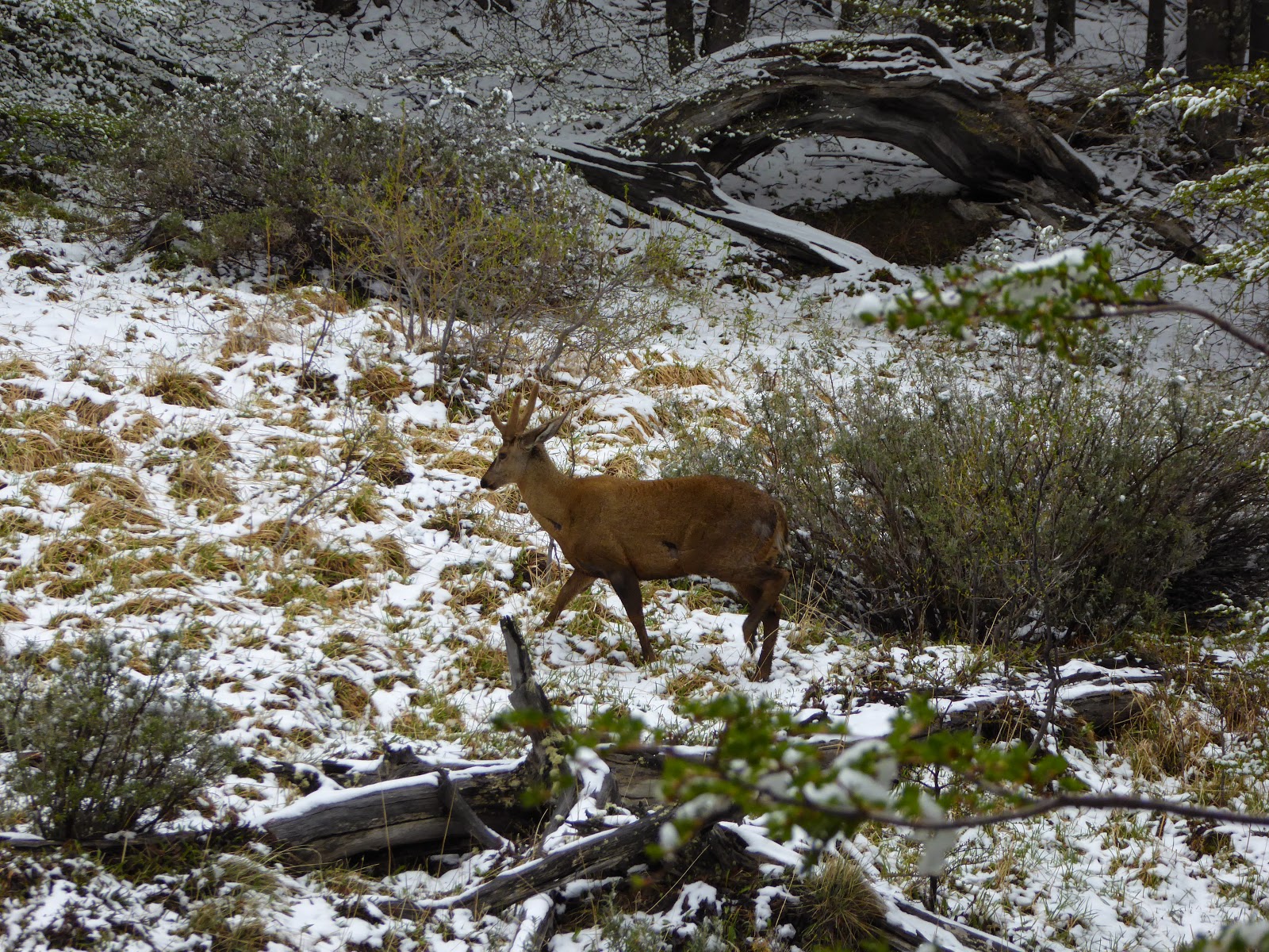
A huemul deer - there are only 20-100 in the national park
On the second morning we saw that the Torres were still covered in cloud, so we decided not to make the 4 hour round trip up to them again, and instead returned back down the valley towards Lake Nordenskjöld. We were able to enjoy the weather beginning to clear as we walked with the aquamarine lake to our left and the cordillera to our right. The colours had dramitcally changed from a black and white film yesterday to technicolour today. Our second refugio was at Los Cuernos (The Horns), named after the nearby distinctive grey granite peaks topped with a stripe of black rock. Our third day took us past the Cuernos into the French Valley. This was our favourite day of the trek - the steep valley passes the Glacier del Francés, where you can see avalanches of ice falling towards the valley floor, and continues to an amazing viewpoint surrounded by mountains and spires of rock. The return from the valley takes you back past these mountains and the glacier, back towards the bright blue lake.

At the top of the Valle Francés
After the valley, we continued through a section of skeletal remains of trees that were burnt in a forest fire in 2011-12. It was started by a hiker and burned around 176km² of the park. There are now strict rules about fire use - there are no fires or stoves allowed on the trails and you are only allowed to cook inside when at the refugios or campsites. Despite the lack of green trees, there are still fantastic views of the mountains reflected in the still lakes.

Los Cuernos reflected in Lake Sköttsberg
Our final two days took us from the Refugio Paine Grande up to Refugio Grey and back again. This walk takes you along the banks of Grey Lake, with icebergs floating in it which have fallen from Grey Glacier. It was a fitting end to the trek to emerge from the forest and see the glacier stretching across the lake in front of you.

Glacier Grey
On the final day, we took the (expensive) catamaran back across the lake to the starting point for our (expensive) bus back to Puerto Natales to relax for a couple of days. We are now returning to Argentina to meet Jo's family for a couple of weeks of trekking around El Calafate and El Chaltén.

Leaving the park, we finally got to see the Torres!
The granite spires in the centre of the photo.

Saturday, 17 October 2015

The Lord of Sipán - The Richest Tomb in Peru

Our next stop having left Chachapoyas was the city of Chiclayo, on Peru's north coast. We took a nightbus here from Chachapoyas, arriving at the antisocial hour of 4 am. It seems that most nightbuses in the north of Peru leave at around 8pm, regardless of the number of hours to the destination, so we've arrived before dawn several times!

Chiclayo is not the most pleasant of cities - it's big, busy and polluted. However, there are several amazing archaeological sites in the area, plus one of Peru's best museums, and we spent most of our time exploring these attractions.

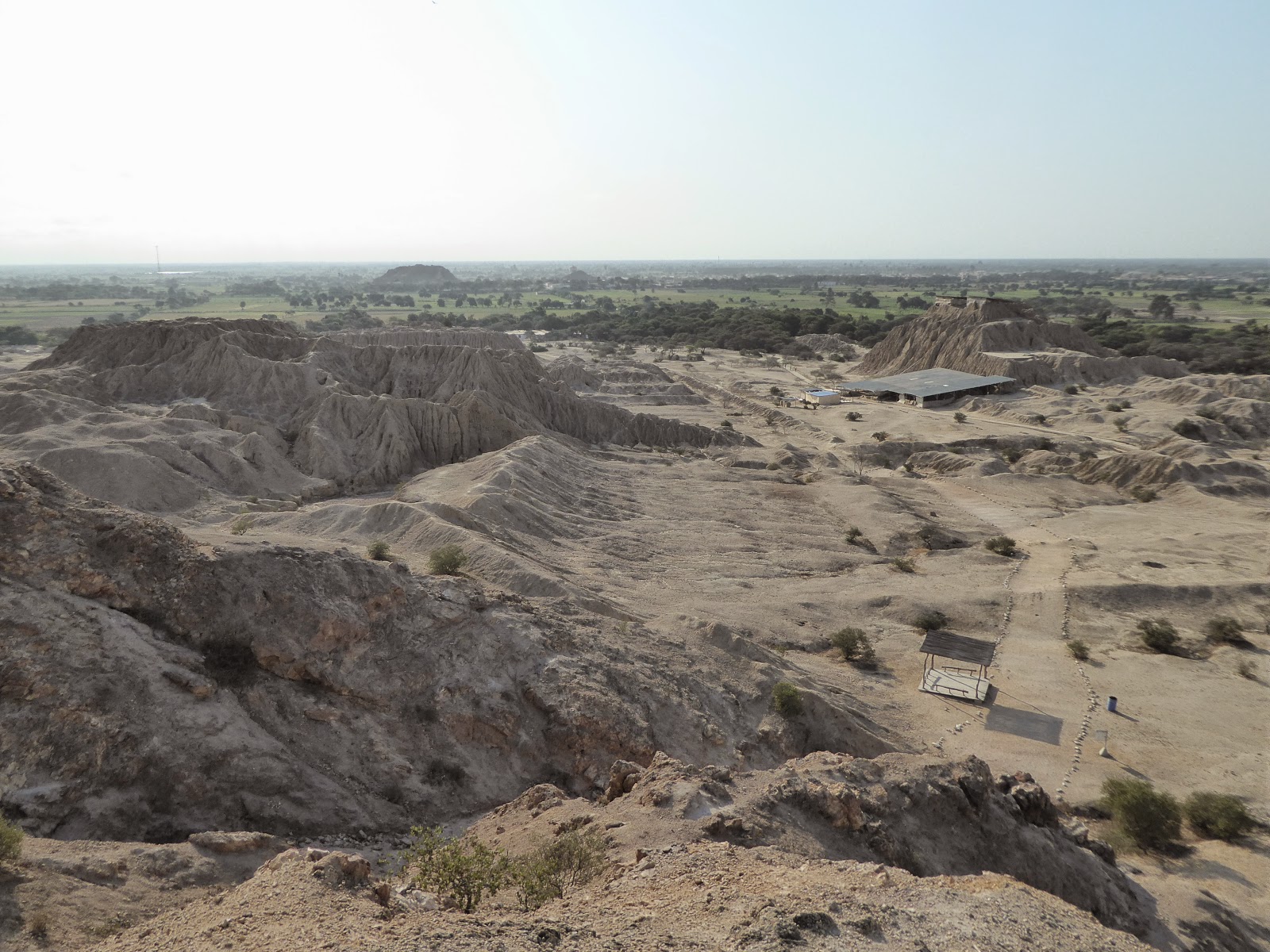
View from Purgatory Hill at Túcume, near Chiclayo
A short colectivo (shared taxi) ride from Chiclayo is the town of Lambayeque, which is home to the Museo Tumbas Reales de Sipán. This museum showcases an incredible collection of treasures that were found in the Royal Tombs of Sipán (dating to about CE 300), a few km away. The discovery of these tombs in 1987 and their subsequent excavation was hugely significant in archaeology. The main tomb of the 14 tombs discovered at Sipán belonged to a great lord of the Moche culture - in fact the most important person of all, equivalent to a king. And unlike most pre-Incan graves, his tomb had been left intact, undiscovered by gravediggers.

This Lord of Sipan was so important that he was buried with hordes of ceramics, gold and silver objects, armour, offerings, animals and even several other people as his 'attendants' into the afterlife - the warriors that were buried with him had had their feet amputated, probably to render them incapable of leaving. The finds from just this one tomb took up an entire floor at the museum, with case after case of unbelievable riches. There were also recreations of several of the tombs as they originally looked when first excavated. It was all really interesting: you can see why these tombs have helped archaeologists such a lot to shed more light on the people and practices of the Moche culture. Sadly we weren't allowed to take any photos.

Pyramids at Túcume
Also near Chiclayo, we visited another site called Túcume. This huge complex of pyramids, now crumbling and covered in mud and sand so they just look like giant mounds scattered across the landscape, was originally built by a different culture - the Sican people (approx CE 800-1350). It continued being used as an important regional centre by the Chimu and later the Incas. At the centre of the site is a hill known as Purgatory Hill, which we climbed to get a great view of the sheer scale of the area.  Purgatory Hill has a story behind its name. At the start of the Spanish occupation of this area, the Spanish lit fires atop this hill and claimed it was purgatory. In an attempt to scare the locals into converting to Catholicism they even dressed as devils and threw non-believing locals to their deaths.

Part of the Sechín site at Casma
We headed down from Chiclayo to Lima via the small town of Casma in order to visit yet another amazing set of ruins (Peru is full of them!) In this case, it was the ancient site of Sechín, dating from around BCE 1600. Most of it is a heap of rubble, but the main temple building has been restored to some extent, and the most interesting feature is the incredible bas relief carvings that decorate all the stone blocks of the building's outer wall. These original carvings represent all sorts of gruesome scenes of war and human sacrifice, including people being beheaded and eviscerated. Little is known about the Sechín people but it doesn't sound like they were the nicest of folks!

Gruesome bas relief carvings at Sechín - note beheaded heads!
We've spent the last couple of days in Lima. Today we went to see the San Francisco Monastery, which has a library dating back to the 16th century. I was in my element and wished I could have opened some of the thousands of ancient books there (sadly you are only allowed to gawp at them from a distance!) Our guide told us some of the larger books have pages of animal skin and covers of wood, and weigh over 20 kg. Wow!

Strange carving of two heads on top of one another, at Sechín
Tomorrow we're leaving to Peru and flying down to Santiago and then onto Patagonia, where with Kev's leg now 100% we will finally be hitting the Torres del Paine National Park that we missed on our previous visit. Can't wait!

Monday, 12 October 2015

The Third Highest Waterfall in the World

After leaving the mountains of Huaraz, we continued zigzagging north through Peru. This first took us to some ancient ruins near Trujillo on the coast then, back in the sierra, to Chachapoyas, with more ruins and the third highest waterfall in the world.

The foot of the Gocta Waterfall - note the tiny people!
We wanted to visit Trujillo as it is close to the UNESCO site of Chan Chan. This was the capital of the Chimu culture that was built around 850 CE. It consists of ten huge citadels, although only one has been restored enough to be worth visiting. As the culture lived by the sea, the walls are covered in designs of fishing nets, fish and sea birds.

Fishing net decorations on the walls at Chan Chan
The highlight of the area around Trujillo was some other, earlier, ruins from the Moche culture (approx CE 100 - 800). Now called the Temples of the Sun and Moon, they are two massive pyramids that are still being excavated. Only the Moon temple can be visited, and the excavations have revealed, amazingly, still intact wall paintings.

Painted walls at the Huaca de la Luna
Continuing on to Chachapoyas, we climbed back up into the mountains to see some more ruins - those at Kuelap. This is an enormous fortress that, like Machu Picchu, is on top of a mountain, giving it fantastic views of the surrounding area. It's the largest pre-Colombian structure in the Americas, with huge outer walls 20m high. The construction was begun in 600 CE by the Chachapoyas culture, and was later occupied by the Inca. It's a fascinating site, and many of the remains are still covered by cloud forest. In fact, Chachapoyas is a Quechua word meaning 'cloud forest'.

Trees covering the ruins at Kuelap
Also close to Chachapoyas are a series of incredibly tall waterfalls. We visited the one at Gocta, which is claimed to be the third highest in the world at 771m. It's an astounding sight seeing it from a the nearby village, then getting closer and seeing the water turn into mist as it falls.

On the way to the Gocta waterfall
We're now heading back south towards Lima, breaking up the journey by visiting some more ruins along the coast.

Monday, 5 October 2015

Trekking Again: Peru's Stunning Cordillera Blanca (And Falling Into a Cactus)

We've spent the past few days in and around Huaraz, a pleasant city in the northern highlands. Huaraz is surrounded by some spectacular scenery in the Cordillera Blanca and Cordillera Huayhuash mountain ranges, and is fast becoming known as the trekking and adventure capital of Peru. You can see several beautiful snowcapped mountains just from the city centre, with the skyline dominated by the majestic Huascarán, the highest in Peru at 6768m. Ready for some more hiking after a break since our long Machu Picchu trek, we were excited to explore the region.

Trekking in the Cordillera Blanca - Santa Cruz Trek, Day 4
The city of Huaraz is up at 3100m, and having had a while down at sea level we needed a couple of days to re-acclimatise to the altitude. Our main objective here was to undertake the famous 4 day Santa Cruz hike in the Cordillera Blanca, voted as one of the world's best treks by National Geographic, and we spent our first day in Huaraz looking round all the local trekking agencies. In fact this hike can be done independently, but we didn't fancy carrying all our own gear (including tents and cooking equipment) around, especially at altitudes of well above 4000m. We decided to sign up for an organised trek with a small company called Eco Ice, departing in two days' time.

Following the river at the start of our Laguna 69 trek
Having got that sorted, we needed to do a day hike to acclimatise further prior to the longer trek. We chose the trek to Laguna 69 (inventive name!), which came highly recommended by several other travellers. The hike started at around 3800m and proceeded across mostly flat terrain, following the river and passing numerous gorgeous waterfalls. After some fairly easy switchbacks, we reached not Laguna 69 but its sister lake, Laguna 68, and from there it was a lot tougher going. Kev was okay with the altitude but I was gasping for breath and had to slow to a snail's pace for the last section! However as we crested the summit and got our first view of Laguna 69, it was all worth it. The most dazzlingly turquoise lake you can imagine, ringed by snowy mountains and glaciers (that from time to time would creak loudly!). The weather had been very changeable on the way up but as we arrived it cleared nicely and we had a wonderful view of the tops of the mountains emerging from the clouds.

Laguna 69
Laguna 69 is hard to do without taking organised transport, and while this was fine on the way it was a little frustrating on the way back. We were some of the fastest people in our busload of people; in fact having got to the top and spent an hour there eating lunch, on our way down we passed the majority of the group still going up! So it was quite a long wait for everyone to finish before our bus could depart for the long 3 hour trip back to Huaraz.

View down the valley at the end of our Laguna 69 trek
On our return from this hike, we found an email from Eco Ice advising us that our Santa Cruz trek had been postponed for two days due to the illness of someone else who'd signed up for it. We were actually not too sad about the delay - it was pretty good not have to get up before dawn again for the second day in a row, and I was grateful for some more acclimatisation time. Rather than hanging about any further in Huaraz, we decided to switch our plans around and visit the nearby historical site of Chavín de Huantar before the trek.

The main plaza at Chavín, with temple behind, surrounded by mountains
We took a very rural local bus out to Chavín, opting to stay a night in the town itself rather than do a day tour from Huaraz (which would have been another 6 hours round trip!). The road wound up into the mountains and then through a tunnel into the neighbouring district of Chavín, where the road surface changed dramatically for the worse: an hour of bumping along, often next to a sickening drop, with feathers blowing in the windows from the dozens of crates of chickens on the roof. Arriving in Chavín town itself in the late afternoon, we checked out what Lonely Planet describes as 'thermal baths'. Expecting some nice hot springs, we were a little disappointed to find they really were 'baths' - several private cubicles with bath size holes in the floor, which we had to fill with a hot tap to a maximum depth of about 8 inches. Not quite what we'd hoped for.

Snake carvings on the steps at Chavín
But our main reason for coming to Chavín was to see the ruins near the town, which make up yet another UNESCO World Heritage Site. This site was built by the Chavín culture between 1200 and 500 BC, and used as a ceremonial centre where local people would come together to worship. The main temple was a huge pyramid, with a sunken plaza in front and stone columns still with original carvings. The whole complex had a ventilation system, earthquake proofing and even a system of channels that would have acted as a sound system, amplifying sounds during ceremonies. Perhaps the most impressive feature was the elaborate series of underground passages, or galleries - some have unbelievably high ceilings and you can still walk though them today. One passage has at its centre a huge carved stone monolith of the Chavin supreme deity, the Lanzón: most of the gallery was dark but the lighting was cleverly designed by the temple's builders so that light from outside beams directly on the sculpture. It was pretty incredible.

Underground gallery at Chavín The monolith representing the Lanzón deity
We returned that afternoon to Huaraz and the next day were up at 5am to start our Santa Cruz trek. Like Laguna 69, this trek goes through the Huascarán National Park in the Cordillera Blanca. The trek was amazing, with scenery reminiscent of Patagonia. The Cordillera Blanca has 33 peaks over 5500m and over 700 glaciers - there were magnificent snowy panoramas everywhere we looked.  We even saw Paramount Mountain; yes, the one in the Paramount Pictures logo! While easier than our ridiculous Machu Picchu trek, it was still challenging at times, particularly with the altitude. Day 2 took us up to a 4750m pass, the highest I have ever hiked to, and that day we camped at 4250m. Two sleeping bags still weren't enough to quite keep out the bitter cold; it's the highest we've slept at on the whole trip and the first time we've had ice inside the tent! We were lucky with the weather though, with clear skies most of the time allowing us stupendous views at both of the highest points.

Looking out on the Paramount Mountain
We were in a group of eight, all lovely people - an Aussie couple, two Israeli brothers, and an Aussie girl and Canadian girl travelling together - plus two guides, a donkey driver and several donkeys. And a dog, which ostensibly belonged to the donkey driver but was nameless and spent most of his time trekking with us. In fact he became rather overprotective, one night waking everyone up barking wildly and attempting to chase away nearby cows.

Kev with 'El Perro' ('The Dog') - we gave him a name!
On the last day of the trek we had a fairly easy walk downhill, next to a lovely river with so many waterfalls that we beat our record number in a day. Kev managed to fall over spectacularly on top of a cactus - the guide got to practise his first aid skills bandaging his hand and later extracting a cactus spine at least an inch long! We celebrated the end of the trek with beers at a shop in the tiny village at the end that was actually run by our guide's aunt and uncle.

One of numerous waterfalls along the river on day 4
That evening we were all also invited to the house of Orlando, the owner of the company, for delicious homecooked dinner and pisco sours, with a demonstration of the making of the latter. Orlando invited us on to the birthday party of one of his colleagues and we had a great evening drinking, chatting and watching the (somewhat odd) Peruvian style of dancing. We'd definitely recommend the Eco Ice company to anybody!

Our final campsite at Llamacorral 
There's plenty more to do here, and in fact we'd like to come back here on holiday in the future to do the challenging and perhaps even more impressive 10 - 12 day Huayhuash circuit in the other cordillera. But for now we're pushing on up north before we fly back down to Patagonia in 2 weeks' time to meet family and do yet more hiking!

Our trekking group at Punta Unión, the high pass on day 2 - new height record!

Saturday, 26 September 2015

The Oldest Civilisation in the Americas

We've spent the last few days getting to know a bit more of Peru's history, from the oldest civilisation in the Americas to the turbulent recent past.

Ayacucho
From Ica, we set off for the less-visited city of Ayacucho, back up in the mountains. Ayacucho was the main base for the Sendero Luminoso (Shining Path) communist organisation. Starting in the early 80s, it waged a guerilla war against the military government that, predictably, responded with violence. This left much of the populace caught between the two sides with thousands of casualties, the majority poor people from the countryside. Sendero Luminoso declined in activity from 1992 when its leader was captured, but there are still sporadic bursts of activity.

The remains of the powerful Wari empire
We used Ayacucho as a base to visit the ruins of the Wari civilisation's capital city. This was a city of an estimated 50,000 people and was the centre of a pre-Inca empire extending over much of Peru between the years 500 and 900. There isn't much left of it today; although there are some remaining buildings and walls still standing, it's hard to imagine a city that big in the abandoned cactus-covered desert.

The main square in Lima
After Ayacucho, we took another night bus back down to the coast for a brief stay in Lima. We're planning to return here in about a month, so we just visited the main sites - the park filled with stray cats in Miraflores (which Jo loved), and a walk around the historic colonial-era centre. It felt a bit depressing as Lima is famous for being covered in white mist for half of the year. We cheered ourselves up by finding one of the first places in which pisco sours were made.

5,000 year old pyramids at Caral
We left Lima to travel further north along the coast to Barranca, the closest town to the ancient ruins of Caral. This is an astounding site - it dates from 5,000 years ago so is one of the cradles of civilisation. It's the oldest such site in the Americas, and was founded at the same time as the Egyptian pyramids were being built. There are remains of pyramids and residential buildings centred around a large square that are in amazing condition considering their age.

Being gluttons for punishment, we've now returned to the mountains, where we're hoping to do some more trekking from Huaraz.

Friday, 18 September 2015

The Nazca Lines - One Of The World's Great Unsolved Mysteries

We arrived in the desert city of Nazca with one intention - to see the famous Nazca Lines. These are a complex series of ancient lines, geometric shapes and stylised motifs, all drawn in the desert and encompassing a huge area. The figures include several designs based on animals and plants, including for example a monkey, a hummingbird and a spider. They are on such a large scale that they can only really be appreciated from the air  - most of the animals are 50-100m long, while the lines are often several km long and 1-3m wide.

The hummingbird figure
The Nazca Lines were created by the Nazca culture and its predecessor, the Paracas culture, between around 500 BC and 500 AD. It would have been a huge undertaking. All the figures and lines were made by clearing away the top layer of dark pebbles and revealing the whiter ground underneath. The lines are so straight that they must have been painstakingly planned and measured - some even theorise that the Nazca must have had hot air balloons to be able to create such precise designs that only become clear from the air. Despite being so old, the geoglyphs have remained in good condition due to the extreme aridity of the desert environment.

Our tiny plane for the Nazca Lines flight
Kev had always wanted to take the flight over the lines, but I was less sure and was very nearly put off by the horror stories of poor safety, horrific air sickness and general very bad organisation! At the last minute I decided to go for it, and was very glad I did. The flight was simply incredible: one of the top experiences of the trip so far. We were in a 6 seater plane with another couple plus pilot and co-pilot. The pilot flew round 12 of the most famous figures, banking first left and then right so that people on both sides of the plane could see. We had amazingly clear views of every figure and could better understand their layout and the sheer immensity of the lines. And no air sickness!

A pair of hands - also sometimes known as the frog
While various theories have been propounded, the purpose of the lines remains unknown. Most experts agree that they probably had some religious significance, perhaps intended as symbols to be seen by the gods above: archaeological evidence shows that ceremonies and festivals may have taken place along them. Other theories link the lines to astronomy and some suggest that they were used as some sort of huge celestial calendar. They could also have been paths leading to water sources - vital when living in such a dry environment. One of the world's enduring mysteries.

In the Cantalloc aqueducts
While in Nazca we explored some ruins from the Nazca civilisation. Firstly the Cantalloc aqueducts, a sophisticated system of subterranean water channels that the Nazca designed for irrigating their crops. They look like interconnected terraces, spiralling down to wells at the bottom, and are still used today. Next the slightly gruesome Chauchilla Cemetery, a burial site from the later Nazca period, still containing mummified human remains in open graves. Interestingly, many of the mummies had headdresses or very long hair styled like dreadlocks. We also visited Cahuachi, the remains of an important ceremonial centre and pilgrimage destination for the Nazca. The ruins here were in excellent condition despite being built of mud bricks, again thanks to the extreme conditions here.

Nazca mummies in the Chauchilla Cemetery 
From Nazca we moved on to the small coastal town of Paracas. We had a long walk around the desert peninsula, admiring the beautiful marine scenery and seeing more flamingoes than anywhere else we've been. The next day we took a boat trip out to the nearby Islas Ballestas, 'the poor man's Galapagos', as many descriptions put it. The wildlife here was stunning - the sky became thick with birds as we approached, and the islands themselves are simply covered in colonies of cormorants, Peruvian boobies and Inca terns, among others. They're also home to Humboldt penguins, sea lions and pelicans and we saw all of these at close proximity. Not the Galapagos, but a pretty good alternative for now!

Playa Roja (Red Beach) - part of the Paracas peninsula 
While in Paracas we happened to be discussing what would happen if a tsunami hit .. and lo and behold the next day after the earthquake in Chile there were tsunami warnings throughout coastal Peru. Fortunately we'd moved on by then 60 km inland to the desert town of Ica, where we enjoyed some wine tasting. Yes, Peru's major wine region is in the desert! There's no comparison with Chilean wine, but the 2012 Petit Verdot was surprisingly good actually. We also visited Ica's excellent museum, and will leave here tonight heading for Ayacucho, up in the central highlands.

So many birds! Peruvian boobies at the Islas Ballestas


Wednesday, 9 September 2015

Trekking to Machu Picchu

A few weeks ago, after hearing about the less-visited Inca ruins at Choquequirao, I looked at my map and saw a very wiggly, mountainous trail that continued on towards Machu Picchu. I remember saying 'that looks ridiculous'. We've just returned from hiking that trail, and the 8 days it took have been some of the hardest, and most rewarding, trekking of our lives. There was very little walking on the flat, and relentlessly steep descents and ascents into and out of canyons:


Day 1: down 800m;
Day 2: down 700m; up 1500m;
Day 3: explore Choquequirao ruins; up 300m; down 500m;
Day 4: down 700m; up 1100m;
Day 5: up 1300m to 4150m San Juan pass; down 700m;
Day 6: up 1100m to 4660m Yanama pass; down 1800m;
Day 7: down 700m;
Day 8: up 500m; down 500m;


The main square at Choquequirao
We'd chosen this trek to avoid the crowds on the other trails in the area and we weren't disappointed. On the first couple of days we saw just a handful of people making their way to, and from, the Choquequirao ruins. We felt privileged to have this remote hilltop city to explore almost to ourselves. This site is also host to the unique 'Llama Terraces' - white stone depictions of llamas making their way up the dizzyingly steep hillside. We were also lucky enough to spot a condor soaring past.

Llamas climbing up their steep terrace
Nobody else continued on past Choquequirao as we did though - we didn't see any other hikers until day 7. This part of the trek contained some of the hardest days - clambering up to passes above 4000m in both sun and snow. The views (when it was sunny) were incredible - of adjoining canyons bordered by mountains topped with glaciers. On one day we also had the unforgettable experience of camping on Inca terraces, looking down to a foaming river far below.

Camping on Inca terraces
On the 7th day we joined the more popular Salkantay trek and were dismayed at the large groups going the same way as us. We managed to find more solitude on the final day, however, when we left at 4:30am to climb to some more Inca ruins at Llactapata. This gave us our first view of Machu Picchu, on the neighbouring peak, although it still seemed a long way away. From there, we made our final descent of the trek, where we had lunch while waiting for a train to take us the short distance to Aguas Calientes - the (tourist trap) entrance town to Machu Picchu.

Our group at the end of the tough, snowy, ascent to the Yanama Pass
During our trek, we were accompanied by a mule train that carried tents, food, cooking equipment and spare clothes for us. It was hard enough with this assistance; it would have been absolute torture to have attempted it without. We were also joined by two amazing chefs - they prepared miraculous food throughout, given that we were camping and they only had two gas hobs to prepare it on. It would have made chefs in many restaurants in Cusco jealous.

Our mule train crossing a stream near Choquequirao
Machu Picchu itself more than lived up to expectations. It's an amazing feeling to see the view that is instantly recognisable across the world. As predicted, it was incredibly busy during the morning, despite getting one of the first buses into the site. After we were given a tour of the main points of interest though, we found a quiet place to have some lunch and read for a while before venturing back. This proved a good strategy as by the afternoon many people had left and we had a much more relaxed time exploring the rest of the ruins.

The culmination of our journey - Machu Picchu
We thought that we'd had the end of hard trekking, but had decided to ascend the mountain behind the city, Machu Picchu mountain. This was another hour of climbing up steep steps, but the view from the top was worth the pain. As well as a fantastic look at the city, it gave a great perspective of its precarious perch atop the famous ridge, surrounded by steep cliffs, glaciers and other mountains.

Machu Picchu from the top of Cerro Machu Picchu
We feel we've had a good introduction to the Inca civilisation now, following our time in and around Cusco, and we're now going to head back down towards the coast and another ancient civilisation - the Nazca and their famous Lines.