Tuesday, 15 March 2016

Curaçao Drinking in Curaçao

In order to skip the dangerous Venezuela, we found the cheapest flight to Guyana would go via the Dutch island of Curaçao. We decided to spend a few days there to do a few dives and drink the famous liqueur. We also discovered that the main town, Willemstad, is a UNESCO world heritage site!

We didn't get any diving photos, so here's one of a beach instead
The dives here were great - we were collected by the guys that run Scubaçao (unfortunately not pronounced Scuba-Cow) and driven around to the dive sites. It made a nice change to be able to just walk off the beach and dive straight away without having to take a boat. The visibility was amazing, around 30m, and there was plenty of healthy coral, lots of different fish and even some turtles. The best site was probably the one called 'Tugboat' - named after a tug that sunk there when a ship dropped an anchor on it. It is now home to several schools of fish and was fascinating to swim around.

The colourful waterfront in Willemstad
When we weren't diving, we walked around the old city, which was founded in 1634. It spent much of its life as a slave trading port, and there are a couple of good museums dedicated to that awful subject today. The slave trade, the proximity to Spanish-speaking Venezuela, its status as part of the Netherlands and today's tourism has led to an interesting mix of cultures. The local language, Papiamentu, is a combination of Portuguese, Spanish, Dutch and English and we found it strange to be able to pick up words of it here and there.

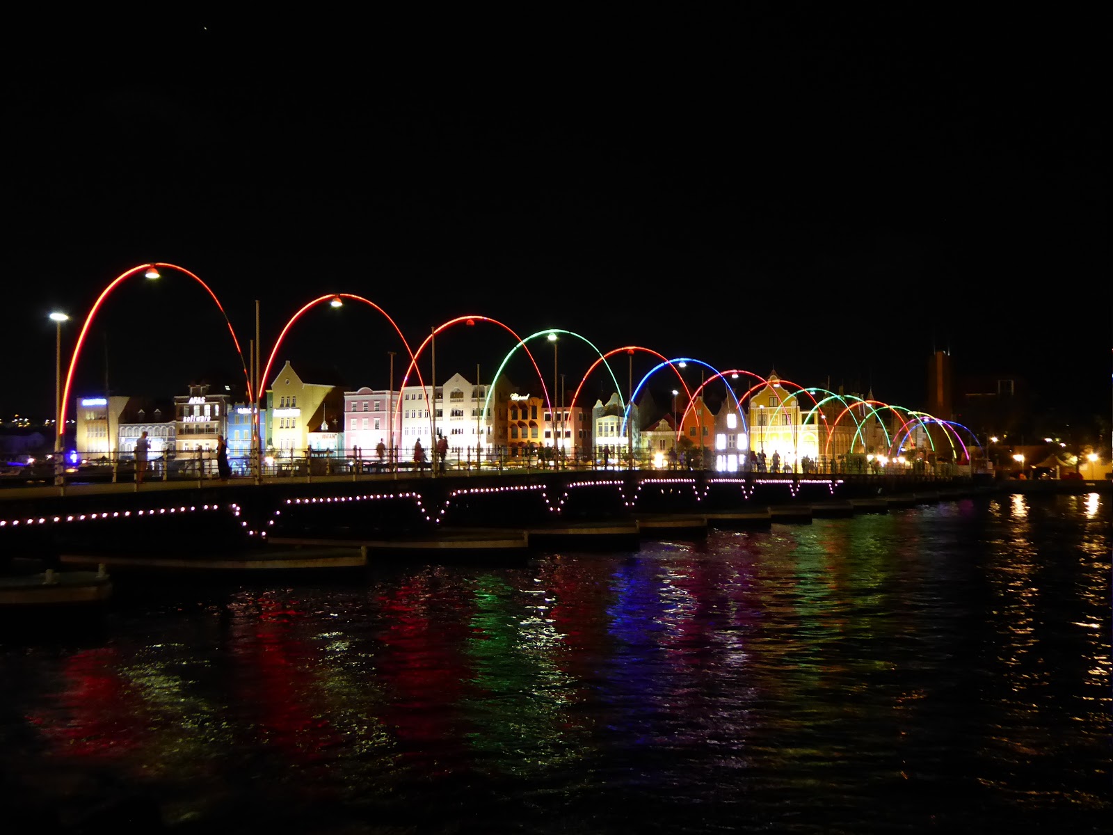
The Queen Emma floating bridge across Willemstad harbour
Willemstad is now home to a unique floating bridge across the harbour entrance, which swings open when a ship needs to pass. Often, those ships are cruise ships, and the island is full of people supping cocktails made from the local blue curaçao liqueur. From our experience, it's used to make rather sickly blue-green cocktails that pack quite a punch.

Cocktails!
We're now recovering from our hangovers and flying back to the mainland, to Guyana.

Saturday, 12 March 2016

Golden Showers - Well, Gold and Showers

We had enjoyed our time in San Agustín and Tierradentro as they're a little further off the gringo trail (especially Tierradentro). However, now it was time to head firmly back into tourist central - Bogotá, Colombia's capital. We took a nightbus from San Agustín that arrived at 5am, and spent a lot of time drinking coffee until we could check in to our AirBnB later on. We'd chosen to base ourselves in the historical district, La Candelaria, which is where most of the attractions are, and the AirBnB was great - run by a very friendly French-Colombian family.

The main square, Plaza de Bolívar, in Bogotá
So, Bogotá. Bogotá is big.Very big. In terms of population, it is the fourth largest city in all of South America and the second largest we've been to behind Buenos Aires, with nearly 10 million people. It is also high, at about 2650m - the third highest capital city in the world after La Paz and Quito. And based on our experience, Bogotá is also rainy. It rained every day while were here, including some enormous thunderstorms that flooded some streets and caused delays at the airport when the control tower was struck by lightning! The weather liked to fool us by appearing beautifully sunny every morning. Thus without fail we'd say, 'shall we take the raincoats? Nah, we won't need them.' And without fail we'd get soaked. Apparently this much rain is unusual for the time of year, and probably due to the El Niño phenomenon.

Incredibly detailed figures in the Gold Museum
There's plenty to do in Bogotá, and we duly visited the majority of its major tourist sites. One of the highlights was the Museo de Oro (Gold Museum), which is one of the best museums we've been to in South America so far. It tells the history of gold in Colombia, focusing on pre-Columbian times and explaining how gold was obtained, what was made with it, the indigenous mythologies surrounding it, and so on. There were plenty of stunning gold items on display, some dating from over 2000 years ago yet incredibly complex, intricate and beautiful in their designs.

Street art on the graffiti tour
Aside from the Gold Museum, we spent one morning doing the popular graffiti tour around La Candelaria and the city centre. This was quite interesting but the group was huge - over 30 people! - and the guide focused more on the artists' styles than on the actual content / meaning behind the street art. We'd have liked to know WHY a given artist had chosen to portray a toucan with a halo, rather than how he'd done it! We also took the cable car (so many cities in South America have cable cars!) to the top of Cerro Monserrate, up at 3100m. The view of the city was quite nice, but sadly the clouds rolled in, the vista deteriorated extremely quickly and the torrential rain began anew. Another day we visited the Police Museum, which included quite a lot of interesting information on the hunt for Pablo Escobar in the early 1990s. On display there was even a desk Escobar owned, which on first sight looks normal, but when kicked in a certain way reveals a false back and false bottom, with several secret compartments. There was also a sophisticated machine Escobar had used for counting banknotes; the only other one of these in the country at the time was in the national bank!

Somewhat hazy view of Bogotá from Cerro Monserrate Wanted poster for Pablo Escobar, in the Police Museum
We had heard a lot about the Salt Cathedral in the town of Zipaquirá, which is often described as 'the marvel of Colombia'. Understandably, we were keen to visit, and as Zipaquirá is not far from Bogotá, we made a day trip. It took us an hour and a half from La Candelaria using the Transmilenio bus-metro thing (more on that to follow!) and then a local bus. On arrival, we were horrified to find the ticket price for extranjeros (foreigners) was 50,000 pesos. That is, £10. Which is a LOT in Colombia! For reference, the Gold Museum cost 3,000. Even for Colombians the price was 28,000, which would definitely price a lot of locals out of coming here. Pretty ridiculous. Still, we thought, we're here now, and we reluctantly paid up.

The main nave in the Salt Cathedral
The Salt Cathedral is basically a huge church built underground in a salt mine, complete with the stations of the cross, also made of salt, on the way. I have to say that the cathedral itself was pretty cool - it was incredible to be in this huge chamber with high ceilings and massive pillars, all deep underground and mostly built of salt, granite and marble. The stations of the cross were also well done, we thought - mostly very understated and simple. However, what we didn't like was the way the entire experience had been made into a massive tourist trap. You had to go round with a guide (totally unnecessary), there was cheesy music playing, and at the end we were greeted with rows of the usual artesania shops. Yes, souvenir shops. And a coffee shop. Down a salt mine! On top of this, anything extra had to be paid for on top of the crazy first price; extra if you wanted to go in the museum, extra to see more of the mine, extra even for toilet paper...! We were very disappointed overall as we felt the whole place was a bit of a farce and a complete rip off. But ho hum, we had to see it really.

One of the Stations of the Cross
Our spirits that day weren't improved by the arduous journey back to Bogotá from Zipaquira. This was our first experience of the Bogotá traffic, which is quite legendary. You'd think in the late afternoon the traffic would be okay coming back into the city, just bad leaving it. You'd think wrong. It took us 3.5 hours to get back. As I mentioned before, part of the journey involved the Transmilenio, which is Bogotá's equivalent of a metro. But rather than a train, it is a bendy bus, 2 or 3 carriages long. Many things about this bus challenged our brains. For example, why have an 'express' bus when it can only go at the same speed as the non-express buses? They all go in the same lane and can't overtake. Or, why not let all the people leaving the bus at the stop get off before everyone else shoves their way on? And, why plan your rush hour schedule so that 90% of the buses coming through the busiest platform at 6.30 pm are 'en transito' (in transit) and not stopping?! Maybe we were just in a bad mood, but we were tearing our hair out a little! Oh for the good old Tube.

View of Bogotá from our AirBnB
On our last day in the city, we decided to treat ourselves to a posh restaurant as a belated celebration of our being away for one year. Said restaurant, Matiz, was 8 or 9 km from where we were staying. Given our experience of the traffic, we left nearly an hour to get there (by taxi). It took us an hour and a half. The taxi driver seemed determined to use the big main road, despite it being completely rammed with traffic. At one point he turned off, and we breathed a sigh of relief, thinking he'd finally seen sense and was going to go via the nearly empty side roads instead. But no, after a few blocks it became clear he was instead just heading across to the other big main road. Which, surprise surprise, was almost stationary. Dare we suggest that if more drivers were willing to use non main roads, the traffic problem might be slightly less bad?!

More street art around La Candelaria
Anyway, end of traffic related ranting! Luckily the restaurant had kept our table and we enjoyed a fantastic meal - a tasting menu of I don't know how many courses that has to be one of the best meals of the trip so far. Cocktails and then wine pairings with each course meant we soon forgot our frustration with the journey. It was a nice way to say goodbye to Colombia, and to Latin America for a while as we move on to destinations more Caribbean in their nature. Next, the island of Curaçao, before we head to the Guyanas.

Monday, 7 March 2016

Guerrillas in the Mountains?

Until quite recently, the area around Tierradentro and San Agustín in the south of Colombia was not the safest due to guerrilla activity. There was an attack on police in September 2014 in Tierradentro and military operations near San Agustín in May 2010. Therefore, when we came across a band of heavily armed men dressed in fatigues while walking on a small path towards the ancient tombs of Tierradentro we felt some trepidation. We're now pretty sure that they were army, though, and we had a nice chat with them about the area, although didn't bring up anything too political!

The path where we came across the army - we obviously didn't try to get any pictures of them!
We'd left the touristy village of Salento for Popayán, one of the larger cities in the south of the country. It's known as the White City (see Arequipa, Perú and Sucre, Bolivia) and lived up to its name, with plenty of colonial buildings and churches lining the streets. We didn't spend much time here, though - we were just using it as a base to get to the UNESCO-listed archaeological sites at Tierradentro and San Agustín.

Popayán - the (a) White City
Not much is known about the pre-Colombian civilisations in this area. All that is left now are underground tombs, particularly in Tierradentro, and hundreds of statues and rock carvings, primarily in San Agustín. They date to the first millennium AD and no-one knows what happened to the cultures that created them - they'd disappeared by the time the Spanish arrived in the 1500's.

A tomb in Tierradentro
The tombs in Tierradentro are situated on four different hilltops around the town of San Andrés de Pisambalá. They consist of a large well of around 5-8m depth which gives access to a cave where bodies were interred in pots. Many of the tombs have no decoration, and many have been looted and damaged. However, some still show colourful, but simple, painted geometric patterns and creepy faces carved into the walls and supporting columns.

Statues guarding a tomb in San Agustín
Although Tierradentro has a few statues, the majority are found at many sites around San Agustín. Again, not much is known about them, but there are many hypotheses as to their meaning. They range from 1m to 7m in height and take on the form of humans, animals and a mix of the two. Some are thought to be gods and others shamans. To our eyes, they appear quite aggressive, with many bearing their teeth and others seeming to represent child sacrifice.

An owl/eagle and snake god?
The town of San Agustín is set in a beautiful location, close to the source of the Magdalena River, which we'd seen before in Honda and Mompox. Here, though, the river was much narrower and raged far below in a deep canyon. We found a good way to visit the river and a number of the archaeological sites was on horseback. This was our first time on horses, and we had a good time sitting on them while they did whatever they wanted!

Jo and her horse, Carmela
From San Agustín, we took a night bus up to Bogotá, which will be our final stop in Colombia before we fly up to the Dutch island of Curaçao for a few days. We're using this as a stop on the way to Guyana, avoiding the currently unstable and dangerous Venezuela.

Sunday, 28 February 2016

Explosive Entertainment in Coffee Country

When we last posted we had just visited the beautiful (and butterfly heavy!) Río Claro. Rather than staying there, we just used it as a two hour stop off to break up the bus journey between Guatapé and Honda. This bus journey was quite interesting, involving 4 different buses in the end and a total of 5 hours travel time. However, all went smoothly in the end and we arrived in Honda in the early evening, not at midnight as we had feared might happen!

The market place in Honda
Honda is not a town on many tourists' itineraries. In fact, it wasn't on ours, until we decided it'd be a good way to get to the coffee region without having to return to Medellín. We were glad we made it here though, as we didn't see a single other Western tourist! This is quite some feat in Colombia, where there is a very set 'Gringo trail' and it can be hard to escape the crowds. We hadn't realised before we got here just how popular Colombia has become as a tourist destination - in South America that we've seen so far it's probably second only to Perú. We've found in this country that we've had to reserve all our accommodation ahead (not something we'd usually do) and a lot of places have been fully booked even a week in advance! So it was nice to get off the beaten track a bit.

Puente Navarro, a famous bridge in Honda 
Lonely Planet has a very small blue box on Honda, entitled 'Hot, Hot Honda'. I kind of imagined this meant 'hot' in the sense of it heating up as a new tourist destination. But as soon as we got out out of the bus we understood that this was in fact to be taken literally. Honda is HOT! One of the hottest towns I've ever been to, including everywhere in Southeast Asia. The average daytime temperature when we were there was around 39 - 40°C, but hotel staff told us it is often up to 45. That's pretty sweltering for us Brits!

View of Honda from the other side of the river
Luckily for us, due to Honda having so few tourists we were able to stay in a lovely hotel complete with terrace, pool and aircon, for a fraction of the price you'd pay elsewhere in Colombia. We spent our one full day here checking out the sleepy colonial town (while getting slowly fried) and then returned to chill out in the pool. The town reminded us a lot of Mompox - it's focused around a river, has a lot of very pretty yet slightly crumbling colonial architecture, and shuts down completely during the hottest hours of the day. It's a pleasant place to wander around, as long as you bring copious amounts of water! We got a lot of glances from locals who were clearly not used to seeing tourists here.

Pretty streets in Honda
On the night we arrived in Honda there was a huge thunderstorm - so big our room got flooded and we had to move upstairs. In fact our arrival heralding rain after a long drought seems to be becoming a theme. In Guatapé they'd had no rain for two months, but when we got there, there was a storm that lasted all night. In Honda they'd had no rain for three months - same story! Thus we weren't too surprised when our bus got to Manizales, our next destination, and lo and behold, the heavens opened. It was torrential! We had to take a taxi from the bus station to our hostel, as our planned method of transport, a cable car, was not operating in the thunder and lightning. Staff at the hostel immediately said to us, 'It's amazing! We've had no rain for three months!'

View of Manizales from our hostel window - this was as clear as it got!
While the rain didn't really affect us in Honda and Guatapé, in Manizales once it started it didn't stop for the whole of our two days there. Therefore a lot of the activities we'd hoped to do - hiking to a viewpoint in the downpour, or climbing a 5000m mountain with zero visibility - didn't appeal so much. We did get out as far as the main square to admire the huge (ugly on the outside, much better on the inside) modern cathedral. But most of our time was spent within our very nice hostel. Manizales is a city in the heart of the coffee region of Colombia, and we'd assumed it'd get plenty of tourists. Actually, not at all - the hostel had only a couple of other people staying, and the restaurants we went to seemed surprised to see us. It was a bonus to find another non-touristy place unexpectedly.

The cathedral in Manizales - the third tallest church building in South America
So where do all the millions of visitors to Colombia's coffee country go? Not to any of the three main cities, it turns out, but to the little town of Salento, a beautiful place surrounded by rolling green hills and several coffee plantations. Salento was a bit of a shock after the last week. From seeing no westerners. suddenly there were big tour groups, souvenir shops everywhere, restaurants with touts outside... it reminded us of San Pedro de Atacama (minus the desert!). But as with many very touristy places, there are good reasons for so many people coming here. In usual style, it was pouring with rain when we first got to Salento, but fortunately after that it only tended to rain heavily in the evenings.

In the Valle de Cocora - note the tall wax palms
Salento is close to the Valle de Cocora, part of the Los Nevados national park. This valley is famous for being the main location in the country where you can find wax palm trees, Colombia's national tree and symbol. We did an excellent 5 hour trek here, starting in cloud forest, climbing up steeply to 3000m and then descending a little to a wonderful hummingbird sanctuary. Here there were hummingbird feeders and so many hummingbirds of all shapes, sizes and colours everywhere! We also saw two 'cusumbos' (coaties) - very furry animals with stripy tails. So cute! From the hummingbird reserve we descended into the valley and finished our walk seeing the wax palms. These are very cool looking - extremely tall, with thin trunks and no branches until right at the top. It was amazing seeing them lining the hillsides, or the tops emerging out of the cloud forest canopy.

Hummingbirds and coatis
View of the wax palm trees along the hills
On our second day in Salento we met up with Ralph and Shehnaaz, our friends from home who we'd seen previously in Taganga. Unfortunately, shortly after we last saw them they were involved in a nasty car accident up on the north coast, and hadn't been able to do much for the past few weeks. We were glad to see them again and see that they were gradually recovering. The four of us spent a day visiting a coffee farm called Ocaso, close to Salento. The tour in English was fantastic - we learnt loads about all aspects of coffee growing and production. As part of the tour we got to pick some of the berries ourselves, see all stages of the process (e.g. de-husking, washing, fermenting, drying, roasting...) and finally of course sample a cup of the freshly brewed final product. I am not the biggest coffee fan, but even to me it tasted pretty good!

Coffee growing - the berries need to be red before they're picked Lady working to sort the coffee beans into 1st and 2nd class Shehnaaz pouring the water ready for our cups of coffee
That evening after a few drinks the four of us decided we had to try a game of Tejo, a traditional sport in Colombia. It's a little like boule, or bowling, but with a twist - explosives are involved! You have to throw a heavy metal disc (2-3 pounds) from a distance of about 10m, aiming at a board angled at 45 degrees and covered in clay. At the centre of the board is a metal ring, and round the ring are placed a few small white triangles which contain gunpowder. The idea is to hit the white targets right on the metal edge so that the impact causes them to explode! The 'explosions' were just a small flame and puff of smoke. Apparently if we'd come during the day the bangs would have been louder - they're not allowed to make too much noise at night (just a thought, shouldn't this rule also apply to Colombian music?!). It was great fun though and we'd have liked to come back for another go.

Ralph playing Tejo
Kev and I needed to get going though so we said goodbye to Ralph and Shehnaaz, who we may or may not see again before we get home in June. Next stop -  south to Popayán.

Friday, 19 February 2016

Visiting the (1990s') Most Dangerous City in the World

Medellín still has a fairly bad reputation internationally, having been the most dangerous city in the world during the 1990s. It was home to the infamous Medellín Cartel, headed by Pablo Escobar. Daily life was plagued by violence, drugs, shootings and bombs. Since then, though, the city has cleaned up its act and in 2013 was even named as the 'most innovative city in the world'. Walking around the central neighbourhoods of El Poblado and Laureles today feels safer than many other cities that we've visited.

Past and future:
A bird sculpture by Fernando Botero, Medellín's
and Colombia's most famous artist, was badly damaged by a bomb, so
the artist made a new one to go alongside it as a symbol of regeneration
The city, a bit higher than we've been recently at an altitude of around 1500m, spreads along a valley floor and up its sides. It is connected by an excellent metro network of trains and cable cars linking the areas further up the valley slopes. One of these cable cars takes you to Arví Park, where we enjoyed strolling through tree lined paths and an artisan's market serving craft beer while taking in spectacular views over the city. On the way back, our train was delayed by an hour with no explanation - it seems that some things aren't too different from home!

Medellín from near Parque Arví
One morning, we set off to the Minorista market to join a tour of exotic fruits. Our guide explained that, a few years ago, this market used to be a pretty sketchy place. It has now changed dramatically and is completely safe - tourism is a way to help the locals  and improve its image. We were each handed a spoon and taken around various stalls trying out different obscure fruits. Our favourites, mangosteen and dragonfruit, recalled our travels in Asia.

Trying guava in Minorista market
A couple of hours outside of Medellín, near the town of Guatapé, is a reservoir towered over by the impressive Piedra del Peñol - a giant granite monolith. We walked up the 740 steps to the top for some magnificent views of the surroundings. Guatapé itself is a really pretty town - almost all of the buildings are brightly coloured and decorated around the base of their walls with tiles showing images of the Piedra, geometric designs and products on sale amongst other things.

The Piedra del Peñol Colourful houses in Guatapé
The Guatapé reservoir from the top of the Piedra del Peñol
From Guatapé, we were heading to Honda but wanted to stop at Río Claro (Clear River) natural reserve on the way. This made the journey a bit of an effort. We took a bus out of Guatapé down to the main road, then hailed down a second bus to the reserve. When we left, we took a third bus along the road to Dorradal, where we were lucky to find a direct bus to the final destination of Honda. Río Claro proved a worthwhile diversion - we spent a couple of hours walking alongside the river lined with cliffs and jungle. The valley is made out of marble, which made interesting rock formations along the river banks and there was plenty of wildlife around. Lots of butterflies (Jo's favourite), a jumping stick insect, a troop of monkeys and, our highlight, a coati climbing a tree.

Río Claro
We've booked flights out of Colombia in March, so don't feel like we have that much time left here now. This meant that we had to leave both Medellín and Guatapé a bit earlier than we'd have liked to. Next, we're now moving on towards the coffee growing region of Colombia.

Wednesday, 10 February 2016

San Andrés Island - Colombian by Name not by Nature

We had always wanted to go to a Caribbean island as part of this trip, but were horrified by the price of the flights to most of the islands from Colombia. However, on reading about the little island archipelago of San Andrés, we realised we might be able to manage our Caribbean island after all.

The San Andrés group is made up of three islands - San Andrés, Providencia, and Santa Catalina. While located in the Caribbean some 700km from Colombia and closest to Nicaragua, the archipelago is actually officially part of Colombia. Flights here from inside Colombia are thus domestic flights, and far cheaper than to anywhere else we'd looked at in the Caribbean. After learning that the islands are also renowned for their diving and snorkelling, we decided to fly out from Cartagena and spend a few days there.

San Andrés island
We booked these flights a couple of weeks in advance and although we'd heard the best things about Providencia, we chose to visit only San Andrés, the largest of the three islands. This might sound counter-intuitive, but we had done some research into dive centres and discovered a couple of highly rated ones in San Andrés, while those in Providencia sounded less promising / safe. San Andrés island itself we had heard was far from paradisical, but as we were going mainly for the diving we thought this would be fine. We also didn't much fancy the 4 hour choppy catamaran ride over to Providencia!

Our flight was full of holidaymakers, mostly Colombian but a lot from the rest of South America too. Especially Brazil, for some reason. San Andrés is a tiny island, only about 10km long, and as our taxi drove us through the main town after landing we noticed that it was indeed pretty ugly. A rapid boom in tourism had indelibly marked the place. Concrete 1960s style buildings everywhere; big hotels, casinos, and souvenir and duty free shops lined the streets. We stayed at a nice place just out of town, about a half hour walk from the centre and away from all the noise.

Holidaymakers on one of the least busy San Andrés beaches
San Andrés and its two sister islands are part of a huge marine protected area of 180,000 km² called the Seaflower Biosphere Reserve. It is recognised by UNESCO as one of its World Network of Bioreserves and is home to one of the largest coral reefs in the world. So a great place to get some more diving experience! We booked through a dive centre called Karibik, run by a friendly German instructor called Christian. For our first three days on San Andrés, we dived twice each day, visiting several different dive sites. It was a new thing for me to just do some fun dives rather than a course, and I have to say, I panicked a little when I first got into the water again - all the equipment felt completely different and unnatural - but once I got underwater it was fine. Christian was a great instructor to dive with - he always let the group dive for as long as possible and shared his air with whoever got low first to allow the rest of the group to continue longer. Most of the dives were 55 - 60 mins, a lot longer than the dives I did in Taganga.

The diving was pretty nice: highlights included the 'Blue Wall' site, where we saw several reef sharks, and a site on the first day where we saw the biggest eel I have ever seen! Sadly we didn't have an underwater camera to capture this, but the monster's head was at least a foot across. It was like some huge underwater serpent in a Disney movie! I had no idea Moray eels could get so enormous. We also enjoyed the coral, which was varied, quite colourful and seemed in good condition. One of the dive sites had what was like a forest of coral, with structures that looked similar to ferns and huge leaves. Really pretty. Plenty of fish too, though fewer and less varied than we had anticipated to be honest. Unfortunately, this is probably a result of overfishing around here.

Palm trees lining the coast road. Note the gorgeous colour of the Caribbean Sea
 in all of these photos!
On our third day of diving, rather than returning to the dive shop in town between dives as we had been doing for the other two days, we spent our break at El Acuario, a small cay that is one of the most popular spots for mainstream tourists here. This gave us our first glimpse of how most tourists spend their time here. The tiny island was absolutely crowded with people, both in the sea, lying on the beaches and spilling out of the one café. It's called 'El Acuario' (the aquarium) because some marine life can be seen while snorkelling there, particularly stingrays. However, the way the stingrays were treated was horrendous! A stingray would be attracted there by feeding it, and then would be captured and held still while tourist after tourist took turns to have their photo taken holding it. So completely opposed to anything we've ever been taught about how to treat marine life (NEVER touch anything). It was quite shocking. Sadly, all the tourist agencies here advertise the stingray tours as an 'amazing, once-in-a-lifetime experience'. There are similar manta tours. We couldn't quite believe these activities were permitted at all, let alone promoted.

On our last day, we didn't do any diving and moved to stay for one night in the south of the island. This was a whole different world from the unpleasant main town - older, more traditional island architecture, cleaner, quieter beaches and a higher proportion of native (i.e. not Colombian) people living there. We had a nice walk around the south coast, happy to be away from most of the tourists. That evening we had dinner in town, and then got a taxi for the 8km or so back to our accommodation in the south. This turned out to be one of the best things we did. The taxi driver was a native islander, speaking Creole English, and it was fascinating, if sobering, hearing his story and the history of the island and its original inhabitants.

One of the quieter, beautiful southern beaches of the island
The San Andrés archipelago was first settled in the 17th century by English Puritans, and later pirates (again English). The English also brought in African slaves. While it later became a possession of the Spanish Crown and then in 1822 officially part of Colombia, no Spanish settlers ever came there and it retained its English-Caribbean flavour. The Colombian government also initially made no attempt to make anything of their island territory, and the islanders were left alone for years. Things only changed when in 1912 Colombia adopted a new policy of 'Colombianisation', enforcing Spanish language, religion and culture on the native San Andrés people.

An even bigger change came when in 1953 the Colombian government declared San Andrés a free port. This led to a huge influx of Colombians looking for a new life in paradise, and a massive construction boom in the 1960s. To give some idea of the magnitude of the change, in 1952 San Andrés had around 6000 inhabitants. In 1973 it was 23,000. Today, it's 80 or 90,000, and the population is still growing rapidly. Land that used to be agricultural has been replaced by housing, lagoons have been filled in and replaced by the port and airport, self-sufficiency has gone in favour of imports from the mainland, and there is a huge problem with rubbish and pollution of the water supply.
Don't think this boat will be going anywhere fast! Horses and an old boat, near
one of the native islanders' houses in the south 
The two taxi drivers we spoke to over the next two days both told us that they did not feel in the slightest bit Colombian. Most natives are descendants of the original English settlers and African slaves. They have names like Williams, Robinson, McDonald or Smith, speak Creole English and are devout Protestants. They resent the way that Colombians are coming in, treating the land how they feel, enforcing their own culture and traditions and not respecting those of the local people. One man we spoke to, a Mr Williams, even asked us to please go and speak to our English government and ask them to come and take back their rightful territory! The other taxi driver told us, with real sincerity, that 'God sent the Colombians to San Andrés to punish us for our sins.' Native people feel the Colombian government simply does not care about San Andrés, other than the revenue it brings in from tourism.

To summarise, we had a great time diving round San Andrés, but as part of our visit, we became more aware of the controversial and sad history of the island and the challenges its people are facing.
Unless things change, it doesn't look like the remaining beauty of San Andrés, its outstanding marine environment and unique island culture will be preserved much longer.

Monday, 1 February 2016

Injury, Illness and More Diving

When we last left you, we'd planned to be heading off into the jungle for four days to trek to 'Ciudad Perdida' ('Lost City'). However, a couple of days before we were to leave, we were struck down by both injury and illness. I managed to hurt my foot once again - tripping on a loose paving stone in Santa Marta left me with a big cut on my toe and an inability to walk comfortably. Not ideal when preparing for a long, hard trek. Jo, meanwhile, was feeling a bit unwell and this worsened for a few days. Aching joints, mild fever, fatigue and a small rash pointed to zika. This is currently all over the news in Europe at the moment, possibly leading to babies born with microcephaly. Luckily, the other symptoms are generally mild, although don't leave you ready to hike. Therefore, we cancelled this plan and spent the time resting and recuperating in an air conditioned room in Santa Marta.

The town hall in Santa Marta
A plaque for Símon Bolívar in Santa Marta's cathedral
Santa Marta doesn't have much in the way of sights, which was perfect to ensure that we didn't venture out too much. We always try to see as much as we can of a place, so it was something of a blessing that there wasn't much here when we needed to rest and recuperate. We did visit the excellent Museo de Oro (Gold Museum), full of artefacts from the ancient Tayrona culture and information on the history of the city. The cathedral was the first resting place of Símon Bolívar, the Liberator of much of South America from Spanish colonialism, before his body was moved to his birth city of Caracas in Venezuela.


After a few days, we felt we needed a change of scenery and went for a couple more restful days in the hills surrounding Santa Marta. We stayed at a hostel/farm a short bus ride outside of the city, followed by a bumpy motorbike ride up a hill. We relaxed by the pool here while feasting on locally grown chocolate, coffee and honey. We also exerted ourselves more on the last day to climb the steep path up to a viewpoint over the whole of the surrounding countryside, with the city in the distance.

The viewpoint near Finca Carpe Diem
We had been filling up time before returning to Taganga for some more diving and to meet up with our friends from home - Ralph and Shehnaaz. We all stayed in the same hostel as last time, which has a terrace with a perfect view over the bay for sunsets. The main reason we'd returned was for diving. The other three successfully completed their PADI Advanced Open Water course with the same instructor as before - Reto Müller. I had already completed the next certification up, so just joined them for some fun dives. Unfortunately, the visibility was often not great for much of it and the currents were quite strong. This made the conditions quite tough, which I guess is a good way to learn!

Wearing diving t-shirts at Casa Baba
While Ralph and Shehnaaz have continued on to the northernmost point of South America, Punta Gallinas, we are returning to Cartagena to then fly to San Andrés. This is a Colombian island in the Caribbean Sea, close to Nicaragua and supposed to have excellent diving.